
Mareugheol
| Mareugheol | ||
|---|---|---|
.svg)
|
|
|
| region | Auvergne-Rhône-Alpes | |
| Department | Puy-de-Dôme | |
| Arrondissement | Issoire | |
| Canton | Brassac-les-Mines | |
| Community association | Agglo Pays d'Issoire | |
| Coordinates | 45 ° 29 ′ N , 3 ° 10 ′ E | |
| height | 436-762 m | |
| surface | 7.54 km 2 | |
| Residents | 198 (January 1, 2017) | |
| Population density | 26 inhabitants / km 2 | |
| Post Code | 63340 | |
| INSEE code | 63209 | |
.jpg) Mareugheol |
||

Mareugheol is a French commune in the region of Auvergne Rhône-Alpes in the Puy-de-Dôme in the Arrondissement Issoire in the canton of Brassac-les-Mines .
General
At 7.54 square kilometers, the municipality is one of the majority of the smaller municipalities in France. It is located at 525 to 762 meters above sea level, 6.4 kilometers northwest of Saint-Germain-Lembron and has 198 inhabitants (as of January 1, 2017).
history
The place is mentioned in 1032 as "Maroiolus". The village was fortified during the Hundred Years War (14th / 15th centuries).
Attractions
- Fort de Mareugheol, remains of a larger (65 m per edge) square fortification of the village made of basalt stones with round corner towers (14th / 15th century); narrow streets inside
- Within this complex, the church of Saint-Victor et Sainte-Couronne, Romanesque with later components (12th-16th centuries), with statues of a breastfeeding Madonna (15th century), Saint Guerrier and Saint Roche (17th century); in the octagonal tower a bronze bell from 1747
- Château d'Eyry (15th century)

Mareugheol Church
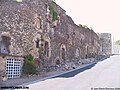
Mareugheol, north front of the fortifications of the medieval village
.jpg)

literature
- André Bossuat: La Vierge allaitant de Mareugheol (Puy-de-Dôme). In: Bulletin Historique et Scientifique de l'Auvergne. Vol. 65, 1945, ISSN 1153-2599 , pp. 86-92.
Web links
Commons : Mareugheol - collection of images, videos and audio files