
Villeneuve (Puy-de-Dôme)
| Villeneuve | ||
|---|---|---|
.svg)
|
|
|
| region | Auvergne-Rhône-Alpes | |
| Department | Puy-de-Dôme | |
| Arrondissement | Issoire | |
| Canton | Brassac-les-Mines | |
| Community association | Agglo Pays d'Issoire | |
| Coordinates | 45 ° 28 ' N , 3 ° 11' E | |
| height | 436-673 m | |
| surface | 4.23 km 2 | |
| Residents | 161 (January 1, 2017) | |
| Population density | 38 inhabitants / km 2 | |
| Post Code | 63340 | |
| INSEE code | 63458 | |
 View of Villeneuve |
||

Villeneuve (also: Villeneuve-Lembron ) is a French municipality with 161 inhabitants (as of January 1 2017) in the department of Puy-de-Dôme in the region Auvergne Rhône-Alpes (before 2016 Auvergne ). It belongs to the Arrondissement of Issoire and the canton of Brassac-les-Mines (until 2015: canton of Saint-Germain-Lembron ).
geography
Villeneuve is located about 37 kilometers south-southeast of Clermont-Ferrand . Villeneuve is surrounded by the neighboring communities of Mareugheol in the north and west, Chalus in the east and south-east, Boudes in the south and Saint-Hérent in the south-west.
Population development
| year | 1962 | 1968 | 1975 | 1982 | 1990 | 1999 | 2006 | 2013 |
| Residents | 120 | 114 | 94 | 102 | 107 | 131 | 142 | 163 |
| Source: Cassini and INSEE | ||||||||
Attractions
- church
- Villeneuve-Lembron Castle
- Donjon of the House of D'Aueilhe

Villeneuve-Lembron Castle
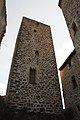
Donjon


Web links
Commons : Villeneuve - collection of images, videos and audio files