Laqueuille
| Laqueuille | ||
|---|---|---|

|
|
|
| region | Auvergne-Rhône-Alpes | |
| Department | Puy-de-Dôme | |
| Arrondissement | Issoire | |
| Canton | Orcines | |
| Community association | Dômes Sancy Artense | |
| Coordinates | 45 ° 39 ′ N , 2 ° 44 ′ E | |
| height | 857-1,000 m | |
| surface | 22.07 km 2 | |
| Residents | 369 (January 1, 2017) | |
| Population density | 17 inhabitants / km 2 | |
| Post Code | 63820 | |
| INSEE code | 63189 | |
| Website | http://www.laqueuille.fr/ | |
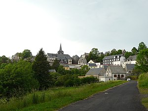
 View of Laqueuille |
||
Laqueuille is a French municipality with 369 inhabitants (as of January 1 2017) in the department of Puy-de-Dôme in the region Auvergne Rhône-Alpes (before 2016 Auvergne ). Mazaye belongs to the Arrondissement Issoire ( Clermont-Ferrand until 2017 ) and the Canton Orcines ( Rochefort-Montagne until 2015 ). The inhabitants are called Laqueuillais .
geography
Laqueuille is located about 40 kilometers west-southwest of Clermont-Ferrand on the River Miouze . Laqueuille is surrounded by the neighboring communities of Briffons in the north and northwest, Perpezat in the north and east, Murat-le-Quaire in the south and southeast, and Saint-Julien-Puy-Lavèze in the west.
population
| year | 1962 | 1968 | 1975 | 1982 | 1990 | 1999 | 2006 | 2013 |
|---|---|---|---|---|---|---|---|---|
| Residents | 577 | 531 | 502 | 402 | 382 | 384 | 397 | 348 |
Attractions
- Sainte-Marie-Madeleine church
- Le Trador waterfall
Web links
Commons : Laqueuille - Collection of images, videos and audio files
