
Saint-Gervazy
| Saint-Gervazy | ||
|---|---|---|
|
||
| region | Auvergne-Rhône-Alpes | |
| Department | Puy-de-Dôme | |
| Arrondissement | Issoire | |
| Canton | Brassac-les-Mines | |
| Community association | Agglo Pays d'Issoire | |
| Coordinates | 45 ° 25 ' N , 3 ° 13' E | |
| height | 458-790 m | |
| surface | 14.23 km 2 | |
| Residents | 329 (January 1, 2017) | |
| Population density | 23 inhabitants / km 2 | |
| Post Code | 63340 | |
| INSEE code | 63356 | |
| Website | http://saintgervazy.free.fr/ | |

Saint-Gervazy is a French municipality with 329 inhabitants (as of January 1 2017) in the department of Puy-de-Dôme in the region Auvergne Rhône-Alpes (before 2016 Auvergne ). It belongs to the Arrondissement of Issoire and the canton of Brassac-les-Mines (until 2015: canton of Saint-Germain-Lembron ).
geography
Saint-Gervazy is located about 41 kilometers south-southeast of Clermont-Ferrand . Saint-Gervazy is surrounded by the neighboring communities of Madriat in the north and north-west, Collanges in the north and north-east, Vichel in the east and north-east, Moriat in the east, Chambezon in the south-east, Léotoing in the south, Apchat in the south-west and Augnat in the west.
Population development
| year | 1962 | 1968 | 1975 | 1982 | 1990 | 1999 | 2006 | 2013 |
| Residents | 242 | 206 | 249 | 226 | 264 | 256 | 290 | 314 |
| Source: Cassini and INSEE | ||||||||
Attractions
- Unsac dolmen
- Saint-Gervazy church
- 16th century castle

Unsac dolmen
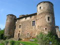
lock


Web links
Commons : Saint-Gervazy - Collection of images, videos and audio files