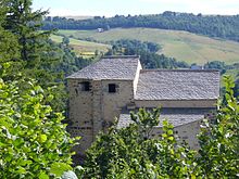
Roche-Charles-la-Mayrand
| Roche-Charles-la-Mayrand | ||
|---|---|---|
|
|
||
| region | Auvergne-Rhône-Alpes | |
| Department | Puy-de-Dôme | |
| Arrondissement | Issoire | |
| Canton | Brassac-les-Mines | |
| Community association | Agglo Pays d'Issoire | |
| Coordinates | 45 ° 26 ' N , 3 ° 0' E | |
| height | 840-1,241 m | |
| surface | 16.22 km 2 | |
| Residents | 40 (January 1, 2017) | |
| Population density | 2 inhabitants / km 2 | |
| Post Code | 63420 | |
| INSEE code | 63303 | |
Roche-Charles-la-Mayrand is a French municipality with 40 inhabitants (at January 1, 2017) in the department of Puy-de-Dôme in the region Auvergne Rhône-Alpes (before 2016 Auvergne ). It belongs to the Arrondissement of Issoire and the Canton of Brassac-les-Mines (until 2015 Canton of Ardes ).
geography
Roche-Charles-la-Mayrand is located about 24 kilometers southwest of Issoire on the eastern slope of the Massif Central . Roche-Charles-la-Mayrand is surrounded by the neighboring communities of Valbeleix in the north and north-west, Chassagne in the north and north-east, Dauzat-sur-Vodable in the north-east, La Chapelle-Marcousse in the east, Mazoires in the south and south-east, Saint-Alyre-ès -Montagne in the south and southwest and Compains in the west.
history
In 1976 the parishes of La Mayrand and Roche-Charles were merged.
Population development
| year | 1962 | 1968 | 1975 | 1982 | 1990 | 1999 | 2006 | 2013 |
| Residents | 86 | 67 | 99 | 70 | 74 | 55 | 52 | 47 |
| Source: Cassini and INSEE | ||||||||
Attractions
- Saint-Roch church

