
Steckborn
| Steckborn | |
|---|---|
 |
|
| State : |
|
| Canton : |
|
| District : | Frauenfeld |
| BFS no. : | 4864 |
| Postal code : | 8266 |
| UN / LOCODE : | CH STC (Steckborn TG) |
| Coordinates : | 716 018 / 280700 |
| Height : | 400 m above sea level M. |
| Height range : | 395–711 m above sea level M. |
| Area : | 8.77 km² |
| Residents: | 3753 (December 31, 2018) |
| Population density : | 428 inhabitants per km² |
|
Proportion of foreigners : (residents without citizenship ) |
26.98% |
| City President : | Roman Pulfer ( FDP ) |
| Website: | www.steckborn.ch |
 |
|
| Location of the municipality | |
  |
|
Steckborn , in the Swiss German local dialect Stäckbore [ˈʃtɛkχˌbɔrə] , is a village and a political municipality in the district of Frauenfeld in the canton of Thurgau , Switzerland .
The local parishes of Steckborn, Gündelhart-Hörhausen and Salen-Reutenen formed the municipality of Steckborn in the Steckborn district until 1998 ; the local community of Mammern belonged to it until 1992. In 1993 the local community of Steckborn was transformed into the political community of Steckborn.
geography
Steckborn lies on the south bank of the Untersee , on the slope of the ridge of the lake and on the deltas of two ravines. On the other side of the Untersee, which is only 1 to 2 kilometers wide here, lies the German municipality of Gaienhofen . The community includes the old town, the area of the former Feldbach monastery , the Weier, Riet and Wolfskehlen settlements, the former Glarisegg Castle and the residential quarters that have recently emerged on the slope of the Seerücken.
history
Prehistory and early history
Due to sediment deposits, flat brook deltas have formed on the northern slope of the ridge. Steckborn lies on such areas and was evidently settled for the first time in the Neolithic Age (from 4300 to 2200 years BC). Pile dwellings arose in the Schanz and in the Turgi Bay to the west and east of the town, and finds such as ceramic vessels, stone ax blades and flint tools can be viewed in the local museum (tower courtyard). Of the presumably at least three bank settlements, Turgi and Schanz were discovered as early as the 19th century and examined from 1881–1882, 1982–1883 and from 2002 onwards. While in the Schanz mainly findings from the Pfyner culture with dendrodata from 3766 to 3576 BC Were known, the dates in the Turgi Bay point to the period from 3838 to 2694 BC. BC, i.e. in the Pfyner, Horgen and Schnurkeramik cultures . Both pile fields are severely affected by erosion and yielded an extraordinarily large number of important individual finds from all three epochs mentioned.
The Roman times (15 BC to 400 AD) also left traces on the Untersee. Some finds from the Tasgetium (today Eschenz) further down the lake are exhibited in the tower courtyard; including a unique plug-in calendar. After the Romans, the Alemanni followed as immigrants and mixed with the Gallo-Roman population. One also suspects that the place name could possibly have originated at that time. The two cemeteries from the early Middle Ages in Chilestigli and at the Obertor are well known, and rich grave inventories from the 7th century have also been found here. Of particular importance is the hoard of around 40 coins, hidden just before 800 east of Steckborn and found in 1830, which, apart from a denarius of Charlemagne, contained exclusively Arabic dirhems from North Africa.
Surname
Steckborn is first mentioned in a document in 1209 (a more recent copy) in the phrase "Wernherus plebanus de Stekboren", then again in 1213: "dominus wernherus plebanus de stecchiboron". The basic word is Old High German for 'house, building, chamber'; the defining word can either go back to the masculine personal name Stëccho, Staccho or to the generic word stëccho 'Stecken, Pfahl'. The place name means either “near the houses of the Stëccho or Staccho” or “near the houses secured by protective posts” or “surrounded by piles” or “near the border posts”.
middle Ages


The city with a triangular floor plan was built on the rubble fan of the Langenergetenbach. Facing the Untersee are the fortified tower courtyard (left) and the town hall (center) with the landing stage. From Rathausplatz, Kirchgasse leads past Obertorplatz with the large fountain to the St. Jakob church (at the top of the triangle).
Around 850 there was already a church. At that time, a certain Selbo is said to have donated his goods in Steckborn to the Reichenau monastery . The monastery already had early church rights and property. To manage these goods, it set up a Kehlhof , which was near the church. In the 13th century, the Reichau ministerials from Steckborn held the Vogtei Steckborn. In 1271 the Reichenau Monastery made Steckborn the center of its possessions in Thurgau. A monastic Ammann exercised the lower court .
A town is mentioned for the first time in 1290 , the existing market was confirmed by King Henry VII in 1313 . The triangular settlement on a brook delta was fortified with walls and towers in the early 14th century. In the 14th and 15th centuries, Steckborn was increasingly urban in character with its small and large councils, its own court (each chaired by the abbot Ammann) and various privileges, although it was still considered a town . The citizens tried to emancipate themselves from the abbey. In 1385 she concluded a castle law contract with the city of Constance , and from 1431 she elected a mayor. However, the abbey still had its own legal district within the city walls with the tower courtyard until it was sold in 1458. In 1490 she owned three mills, ten houses, 72 pieces of land, the church property and the ferry loan across the lake in addition to the Kehlhof . So Reichenau preserved its influence in Steckborn until the Reformation . After the abbey was incorporated into the Constance bishopric in 1540, the Steckborn Lower Court including Feldbach and Glarisegg belonged to the Bishop of Constance until 1798, while the confederates who ruled in Thurgau from 1460 had the highest jurisdiction .
The medieval parish of Steckborn also included Salen-Reutenen and Berlingen around 1524, the Cistercian convent Feldbach , founded in 1253/54, was church-independent. The 12/13 St. Jakobskirche, which was enlarged in the 19th century, was incorporated into Reichenau Abbey in 1344.
Early modern age

In the course of the Reformation , Steckborn converted to the new faith in 1515, but Reichenau Abbey enforced the reintroduction of Catholic worship in the parish, which was henceforth parity . In 1540, the Bishop of Constance took over the rule of law as well as the collature for both denominations. Religious conflicts between the Reformed majority and the Catholic minority were frequent. In 1766 the town church was rebuilt as a parity church by the well-known master builder Franz Anton Bagnato on the site of previous buildings .
In 1649, Steckborn formed its own main military team . An armory was built in 1658 and a new town hall in 1667. In the 17th and 18th centuries, the local tin and pot casting trade as well as the Steckborn pottery and stove painting attracted widespread attention. In 1711 the common land was divided. In 1756 the city acquired mills, water rights and all Ehafts . With 600 Jucharten forest, the affluent community was one of the largest forest owners in Thurgau at the end of the 18th century.
1798 until today
.jpg)

With the establishment of the Canton of Thurgau Steckborn was Munizipalgemeinde as the center of the submarine to the district capital . In 1812 the Feldbach Monastery and Glarisegg Castle were added to the local community of Steckborn. The expansion of the Seestrasse in 1823 and the road to Frauenfeld from 1841–1847, the steamship operation on the Untersee from 1825 and the connection to the lake line completed in 1874 improved transport connections. A poor institution was set up in the Turmhof in 1836 and has housed the local history museum since 1937.
Today's Protestant town church received a tower from 1833 to 1835. In 1848 the Cistercian convent Feldbach was abolished with the other Thurgau monasteries . Since 1962, when the Catholics built their own church, the church has been used exclusively by the Evangelical parish of Steckborn. Between 1962 and 1963 the Church of St. James was built. The 42 meter high tower was clad with solar cells on the south side in 1993, so that as a solar tower it has become a new landmark of Steckborn.
Steckborn remained the district capital until 2010. According to the new district division of the canton of Thurgau, it is now a political municipality in the Frauenfeld district. The place of jurisdiction was also moved to Frauenfeld.
coat of arms
Blazon : A yellow ring in blue with two crossed yellow sticks .
Today's coat of arms is an old, talking coat of arms . It probably combines an older city coat of arms (ring) with a variant of the Labhart family coat of arms (bars).
The older city coat of arms in the form of a golden ring appears in the glass painting from 1543 in the Stein am Rhein town hall; later it only appears on the Feldbacher Glocke from around 1683–1687. The ring is perhaps taken from the coat of arms of the Landenberg or the Knöringer and could be related to the transfer of city rule from Reichenau to the bishopric of Konstanz in 1540. The municipal coats of arms of neighboring Berlingen and Allensbach have similar forms .
population
 |
| 1850 | 1900 | 1950 | 1990 | 2000 | 2010 | 2019 | |
|---|---|---|---|---|---|---|---|
| Political community | 3320 | 3497 | 3736 | ||||
| Municipal parish | 2292 | 2541 | 3798 | 4466 | |||
| Local parish | 1509 | 1733 | 2846 | 3381 | |||
Of the 3736 inhabitants of the municipality of Steckborn in 2019, 1003 or 26.89% were foreign nationals. 1182 (31.64%) were Protestant Reformed and 1093 (29.26%) were Roman Catholic.
traffic
Steckborn is accessed from the main road Schaffhausen – Kreuzlingen and is connected to public transport by train and bus. There is a train station, where the per direction every half hour a train of Seelinie Schaffhausen-Kreuzlingen-St. Gallen holds. A post bus connection leads to Frauenfeld . In terms of tourism, the connection between the Swiss shipping company Untersee and the Rhine to Stein am Rhein - Schaffhausen and Konstanz - Kreuzlingen is important.
economy


In 2016, Steckborn employed 1,066 people (converted to full-time positions). Of these, 2.1% were employed in agriculture and forestry, 39.5% in industry, trade and construction and 58.5% in the service sector.
The former monastery rooms on the Feldbach area could be used by commercial enterprises and emerging industries from the middle of the 19th century. The inventor and company founder Friedrich Gegauf began producing the world's first hemstitch sewing machine here . This resulted in today's global company, Bernina Sewing Machine Factory, which employed 800 people in 1995 and 350 in 2010.
Later, the manufacturer Samuel Bächtold bought the land and mainly manufactured petrol engines and other machines in his company. In 1923 the Borvisk artificial silk factory was set up in the former monastery area, which in 1929 offered over 1,100 jobs. This textile chemical company was an important employer in the region until 1974. After 1970 there were job losses and population losses, which the community on the lake sought to make up for with tourism funding. In 2005 the service sector provided well over half of the jobs.
Today the Feldbach area serves as a leisure facility, as the location of a school building, a seminar hotel and the Phönix Theater (theater in the pump house). There are also uses for trade, commerce, services and living.
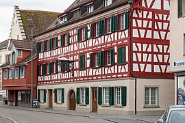
Attractions
The little town was fortified. Parts of the city wall are still preserved today. The closed townscape was achieved mainly due to a planned development.
Some important old buildings are under federal protection, the small town of Steckborn and Glarisegg Castle are listed in the inventory of places worthy of protection in Switzerland .
- Tower courtyard
- town hall
- Glarisegg Castle
- Protestant church
- Catholic Church of St. James , with solar tower

"Skyline" of Steckborn am Untersee

Steckborn - view of town and lake

West entrance to the city

Village street with Protestant church
Former Gasthaus "zum Schwanen"

Old school house and house "zum Oberhof"


Personalities
Born in Steckborn
- Hans Ulrich Hanhart (1623–1672), Winterthur city physician, co-founder of the Winterthur city library
- Christoph Labhart (1644–1695), glyptist (crystal cutter)
- Daniel Düringer (1720–1786), painter, mayor of Steckborn until 1769
- Emanuel Labhardt (1810–1874), landscape painter
- Heinrich Düringer (1747–1833), stove maker
- Johann Melchior Gräflein (1807–1849), lawyer, politician, Cantonal Councilor 1838–1849
- Philipp Gottlieb Labhardt (1811–1874), lawyer, politician, national and government councilor
- Gustav Albert Wegmann (1812–1858), architect
- Johannes Herzog (1822–1883), pastor, school inspector, Thurgau government councilor 1857–1862
- Gabriel Wüger (1829-1892), origin. Jakob Wüger, painter, Benedictine
- Ulrich Guhl (1838-1924), ref. Pastor, politician (FDP), Thurgau Cantonal Council 1878–1917
- Alfred Kreis (1857–1943), lawyer, public prosecutor, free-spirited councilor 1893–1926
- Jakob Labhardt (1881–1949), Chief of Staff
- Ernst Wuhrmann (1883–1957), architect
- Fritz Gegauf (1893–1980), founder of the local Fritz Gegauf AG (well-known product Bernina sewing machine ), honorary citizen of Steckborn
- Otto Frei (1924–1990), journalist, author
- Andy Guhl (* 1952), improvisation musician, sound artist, architect
- Marco Forrer (* 1996), ice hockey player
- Sandro Forrer (born 1997), ice hockey player
Personalities who worked in Steckborn
- Adolf Deucher (1831–1912), doctor and politician (FDP), Federal Councilor 1883–1912
- MC Escher (1898–1972), Dutch graphic artist, lived here until 1935 after moving from Italy.
- Maria Dutli-Rutishauser (1903–1995), writer, lived in Steckborn from 1927 until her death
- Hans Baumgartner (1911–1996), photographer and teacher, honorary citizen of Steckborn
literature
- Ferdinand Isler: Old and New from Steckborn. In: Thurgauer Jahrbuch, Vol. 12, 1936, pp. 13-24 ( e-periodica ).
- Alfons Raimann, Peter Erni: The art monuments of the canton of Thurgau. Volume VI: The Steckborn district (= Art Monuments of Switzerland, Volume 98). Edited by the Society for Swiss Art History . Bern 2001, ISBN 3-906131-02-5 ( digitized version ).
- Gregor Spuhler: Steckborn. In: Historical Lexicon of Switzerland .
Web links
Individual evidence
- ↑ Permanent and non-permanent resident population by year, canton, district, municipality, population type and gender (permanent resident population). In: bfs. admin.ch . Federal Statistical Office (FSO), August 31, 2019, accessed on December 22, 2019 .
- ↑ a b Thurgau in figures 2019 . On the website of the Statistical Office of the Canton of Thurgau (PDF file; 1.8 MB), accessed on April 28, 2020.
- ↑ a b Eugen Nyffenegger, Oskar Bandle : The settlement names of the canton of Thurgau. 2nd half volume: Historical names dictionary K - Z and directories. Huber, Frauenfeld / Stuttgart / Vienna 2003, pp. 1208–1210; Lexicon of Swiss municipality names . Edited by the Center de Dialectologie at the University of Neuchâtel under the direction of Andres Kristol. Frauenfeld / Lausanne 2005, p. 852.
- ↑ a b Localities and their resident population. Edition 2019 . On the website of the Statistical Office of the Canton of Thurgau (Excel table; 0.1 MB), accessed on April 28, 2020.
-
↑ a b c d e f g h i j k l m Hansjörg Brem, Gregor Spuhler : Steckborn. In: Historical Lexicon of Switzerland .
These sections are largely based on the entry in the Historical Lexicon of Switzerland (HLS), which, according to the HLS's usage information, is under the Creative Commons license - Attribution - Share under the same conditions 4.0 International (CC BY-SA 4.0). - ↑ a b c d population development of the municipalities. Canton Thurgau, 1850–2000 and resident population of the municipalities and change from the previous year. Canton of Thurgau, 1990–2018. On the website of the Statistical Office of the Canton of Thurgau (Excel tables; 0.1 MB each), accessed on April 28, 2020.
- ^ Vorarlberg State Museum Bregenz. In: Listed! Finds of pile dwellings on the Untersee. In: Südkurier of September 9, 2011.
- ↑ a b c history of Steckborn. On the website of the municipality of Steckborn, accessed on January 1, 2020
- ↑ a b c Our church on the website of the cath. Parish of St. Jakobus Steckborn, accessed on July 12, 2016.
- ^ Parish website, Our Church section . Retrieved May 15, 2019.
- ↑ a b municipal coat of arms . On the website of the State Archives of the Canton of Thurgau, accessed on December 8, 2019
- ↑ JL Locher, Flip Bool, Bruno Ernst: MC Escher, his life and complete graphic work. Abradale Press / Harry N. Abrams, New York 1982; Ed. 1992, pp. 32, 34, 47.
Basadingen-Schlattingen | Berlingen | Diessenhofen | Eschenz | Felben-Wellhausen | Frauenfeld | Gachnang | Herdern | Homburg | Hüttlingen | Hüttwilen | Mammers | Matzingen | Muellheim | Nine-shape | Pfyn | Schlatt | Steckborn | Stettfurt | Thundorf | Uesslingen book | Wagenhausen | Warth-Weiningen
Former municipalities: Basadingen | Book near Frauenfeld | Dettighofen | Eschikofen | Fahrhof | Felben | Gerlikon | Gündelhart-Hörhausen | Harenwilen | Herten | Horgenbach | Huben | Islikon | Kaltenbach | Kefikon | Kurzdorf | Langdorf | Langenhart | Lance neunforn | Lustdorf | Mett-Oberschlatt | Mettendorf | Niederneunforn | Niederwil | Walnut trees | Oberneunforn | Oberwil | Rheinklingen | Salen-Reutenen | Schlattingen | Uerschhausen | Uesslingen | Subdivision | Warth | Weiningen | Wellhausen | Wetzikon | Wilen bei Neunforn | Willisdorf
Canton of Thurgau | Districts of the Canton of Thurgau | Municipalities of the Canton of Thurgau