
Putnam County, Illinois
 Putnam County Courthouse |
|
| administration | |
|---|---|
| US state : | Illinois |
| Administrative headquarters : | Hennepin |
| Address of the administrative headquarters: |
Putnam County Courthouse 120 N. 4th Street Hennepin, IL 61327 |
| Foundation : | January 13, 1825 |
| Made up from: | Original County |
| Area code : | 001 815 |
| Demographics | |
| Residents : | 6006 (2010) |
| Population density : | 14.5 inhabitants / km 2 |
| geography | |
| Total area : | 446 km² |
| Water surface : | 32 km² |
| map | |
 |
|
| Website : www.co.putnam.il.us | |
The Putnam County is a county in the US -amerikanischen State Illinois . In 2010 , the county had 6,006 people and a population density of 14.5 people per square kilometer. The county seat is Hennepin .
geography
The county is located in north central Illinois and is the smallest county in the state. It has an area of 446 square kilometers, of which 32 square kilometers are water. The county lies on either side of Senachwine Lake , a natural widening of the Illinois River . The following neighboring counties border Putnam County:
| Bureau County | ||
.svg)
|
LaSalle County | |
| Marshall County |
history

| Population development | |||
|---|---|---|---|
| Census | Residents | ± in% | |
| 1830 | 1310 | - | |
| 1840 | 2131 | 62.7% | |
| 1850 | 3924 | 84.1% | |
| 1860 | 5587 | 42.4% | |
| 1870 | 6280 | 12.4% | |
| 1880 | 5554 | -11.6% | |
| 1890 | 4730 | -14.8% | |
| 1900 | 4746 | 0.3% | |
| 1910 | 7561 | 59.3% | |
| 1920 | 7579 | 0.2% | |
| 1930 | 5235 | -30.9% | |
| 1940 | 5289 | 1 % | |
| 1950 | 4746 | -10.3% | |
| 1960 | 4570 | -3.7% | |
| 1970 | 5007 | 9.6% | |
| 1980 | 6085 | 21.5% | |
| 1990 | 5730 | -5.8% | |
| 2000 | 6086 | 6.2% | |
| 2010 | 6006 | -1.3% | |
| Before 1900 1900–1990 2000 2010 | |||
Putnam County was formed on January 13, 1825 as the original county from the Territory of Illinois. The western part of the county was home to the Potawatomi Indians, displaced by white settlers. It was named after Israel Putnam (1718–1790), a hero in the French and Indian Wars and later general in the Revolutionary War. The Hennepin courthouse is the oldest in use in Illinois.
Territorial development
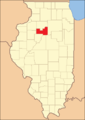
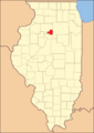
Putnam County originally extended to Wisconsin and Lake Michigan . The county's last shrinkage was in 1839.
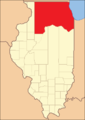
Putnam County from its inception in 1825 to 1827
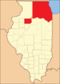
1827 to 1831

1831 to 1837
1837 to 1839
1839 until today


Demographic data
According to the 2010 census , Putnam County had 6,006 people in 2,482 households. The population density was 14.5 inhabitants per square kilometer. Statistically, 2.41 people lived in 2482 households.
The racial the population was composed of 97.8 percent white, 0.8 percent African American, 0.1 percent Native American, 0.3 percent Asian and other ethnic groups; 0.9 percent were descended from two or more races. Hispanic or Latino of any race was 4.3 percent of the population.
20.7 percent of the population were under 18 years old, 61.2 percent were between 18 and 64 and 18.1 percent were 65 years or older. 49.6 percent of the population was female.
The median income for a household was 52,409 USD . The per capita income was $ 25,510. 11.6 percent of the population lived below the poverty line.
Putnam County localities
1 - partially in LaSalle County
structure
Putnam County is divided into four townships :
| Township | Population (2010) |
FIPS |
|---|---|---|
| Granville Township | 2934 | 17-31030 |
| Hennepin Township | 1261 | 17-34124 |
| Magnolia Township | 1066 | 17-46123 |
| Senachwine Township | 745 | 17-68627 |
See also
Individual evidence
- ↑ GNIS-ID: 424279. Retrieved on February 22, 2011 (English).
- ↑ a b c U.S. Census Bureau, State & County QuickFacts - Putnam County, IL Retrieved January 2, 2013
- ↑ a b National Association of Counties. Retrieved January 2, 2013
- ^ US Census Bureau - Census of Population and Housing.Retrieved March 15, 2011
- ^ Extract from Census.gov.Retrieved February 15, 2011
- ↑ Missouri Census Data Center - Illinois ( page no longer available , search in web archives ) Info: The link was automatically marked as defective. Please check the link according to the instructions and then remove this notice. Retrieved January 2, 2013
Web links
List of counties in Illinois
Adams |
Alexander |
Bond |
Boone |
Brown |
Bureau |
Calhoun |
Carroll |
Cass |
Champaign |
Christian |
Clark |
Clay |
Clinton |
Coles |
Cook |
Crawford |
Cumberland |
DeKalb |
DeWitt |
Douglas |
DuPage |
Edgar |
Edwards |
Effingham |
Fayette |
Ford |
Franklin |
Fulton |
Gallatin |
Greene |
Grundy |
Hamilton |
Hancock |
Hardin |
Henderson |
Henry |
Iroquois |
Jackson |
Jasper |
Jefferson |
Jersey |
Jo Daviess |
Johnson |
Kane |
Kankakee |
Kendall |
Knox |
LaSalle |
Lake |
Lawrence |
Lee |
Livingston |
Logan |
Macon |
Macoupin |
Madison |
Marion |
Marshall |
Mason |
Massac |
McDonough |
McHenry |
McLean |
Menard |
Mercer |
Monroe |
Montgomery |
Morgan |
Moultrie |
Ogle |
Peoria |
Perry |
Piatt |
Pike |
Pope |
Pulaski |
Putnam |
Randolph |
Richland |
Rock Island |
Saline |
Sangamon |
Schuyler |
Scott |
Shelby |
St. Clair |
Strong |
Stephenson |
Tazewell |
Union |
Vermilion |
Wabash |
Warren |
Washington |
Wayne |
White |
Whiteside |
Will |
Williamson |
Winnebago |
Woodford
Coordinates: 41 ° 12 ′ N , 89 ° 17 ′ W