Rabenau (Saxony)
| coat of arms | Germany map | |
|---|---|---|
|
Coordinates: 50 ° 58 ' N , 13 ° 39' E |
|
| Basic data | ||
| State : | Saxony | |
| County : | Saxon Switzerland-Eastern Ore Mountains | |
| Height : | 320 m above sea level NHN | |
| Area : | 30.73 km 2 | |
| Residents: | 4420 (Dec. 31, 2019) | |
| Population density : | 144 inhabitants per km 2 | |
| Postal code : | 01734 | |
| Primaries : | 0351 (Karsdorf: 03504) | |
| License plate : | PIR, DW, FTL, SEB | |
| Community key : | 14 6 28 300 | |
City administration address : |
Markt 3 01734 Rabenau |
|
| Website : | ||
| Mayor : | Thomas Paul ( CDU ) | |
| Location of the town of Rabenau in the Saxon Switzerland-Eastern Ore Mountains district | ||
Rabenau is a small town between Dippoldiswalde and Freital in the Saxon district of Saxon Switzerland-Eastern Ore Mountains . The place Rabenau is the administrative seat of the six districts of the city. This extends over an area of 30 square kilometers on the northern edge of the Eastern Ore Mountains.
geography
location
| Somsdorf | Freital | Obernaundorf |

|
Brooch | |
| Lübau | Spechtritz | Oelsa |
Rabenau is located on a south-facing slope that drops from a saddle-shaped ridge to the Oelsabach . The highest points are the Rabenauer Höhe (352 m) to the west with the transmission tower and the height near the water tower and the Rabenauer Schule. The north-facing slope to the north of the city ("lice meadows") is hardly built on. The lowest point of the place is the Rabenauer Mühle on the Rote Weißeritz .
City structure
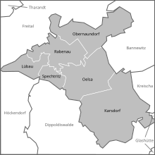
In addition to the core city, the city of Rabenau includes five other districts in the surrounding area. In the following table these are given with the year of incorporation and their population on May 9, 2011.
| District | since | Residents | |
|---|---|---|---|
| Karsdorf | 1994 | 457 | |
| Lübau | 1952 | 211 | |
| Obernaundorf | 1974 | 327 | Upper poise houses |
| Oelsa | 1994 | 1226 | |
| Rabenau | - | 1935 | Waldfrieden settlement |
| Spechtritz | 1952 | 191 |
Land use
In addition to the built-up districts, a large part of the area is used for agriculture , especially for arable farming . Almost half of the surface of forest areas covered as the Dippoldiswalder Heide square kilometers by 12, the Poisenwald square kilometers 2.22, the Rabenauer Vorholz 0.72 square kilometers at Eckersdorf, the Rabenauer forestry square kilometers with 0.79, and the Rabenauer Buchwald with the forests in Rabenauer Grund with 1.11 km².
history
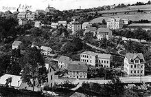
The place was mentioned for the first time indirectly as "Rabinowe" in the year 1235. Frankish settlers under the Burggrave-Dohna nobleman Burchhardus de Rabinowe , who is probably identical with the 1206 mentioned Burkhard von Kaitz, are considered to be colonists . The Rabenau rulership with its fortifications, Rabenau Castle, erected there around or shortly before 1200 on a rock spur above the Oelsabach valley , appears to have been laid out from Kaitz . This group of settlements is part of the colonization of the burgraves of Dohna on the Weißeritzen, with a focus on Thorun Castle (Pesterwitz), Rabenau, Dippoldiswalde , Höckendorf and Ruppendorf .
After the Dohna feud (1385-1402), the rule came into margravial-Meissnian possession and lost its strategic importance. Rabenau obtained its town charter in 1488.
During the Thirty Years War (1618-1648) the place suffered several looting and was set on fire in 1639 by Swedish troops.
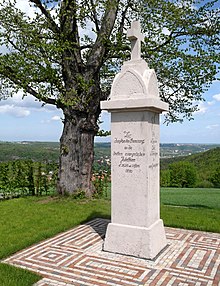
In addition to agriculture, the artisanal wood processing was an essential livelihood in Rabenau. From the 16th century the craft of chair making developed in Rabenau and the surrounding area. The court geographer Adam Friedrich Zürner reported in 1720 about Rabenau that almost all of the residents were chair makers . The Saxon postal mileage pillar built in 1730 disappeared from the market in the 19th century. It was replaced by a replica on 2013.
A silver mine was already located in 1797 under the owner Wünschmann as "Silver Raven Erbstollen" on the Pfarrwiese, which was followed by another called "Silver Raven Fundgrube" by the Rabenauer Eigenlöhnergesellschaft on the road to the Rabenauer Mühle am Mühlberge with a few small pings.
Around 1830 the Rabenauer Mühle was licensed. It burned down in 1869 and was rebuilt as a Swiss-style restaurant and wood grinding shop . In the age of industrialization and the Wilhelminian era , the settlement area expanded to higher parts of the steeply sloping southern slope. The volunteer fire brigade was founded in 1875, and in the same year Rabenau became part of the Dresden administration . In 1882 Rabenau was connected to the Weißeritztalbahn , which was of great importance for the local chair making industry. At the same time, the local connecting road from Eckersdorf (district of Hainsberg or Freital , today Freitaler Straße) was built and replaced the steep Eckersdorfer Weg. The Waldfrieden settlement was built on this road above the Rabenauer Grund. The town hall and a large number of distinctive town houses were built on the market square during the founding period. 1832, the construction was carried out a first Röhrwasserversorgung means of studs which begins under the residential valley and ends at the intersection Freitaler / Upper Naundorfer street in a well house and came in wooden pipes to the houses, in 1896 the building was made of the high container with a first aqueduct in 1911 was in Rabenauer Reason the hydropower plant is in operation. At the beginning of the 20th century, the city of Rabenau built a free-flowing drinking water pipeline, which draws its water from the Paulsdorfer Heide near Höckendorf and, through the construction of a water tower at the second highest point in the village, represented a contemporary local drinking water network.
On May 8, 1945 Rabenau was occupied by Soviet troops, at least one civilian population was killed. Relatives and sympathizers of the KPD and SPD were entrusted with the city administration. As a result, several large farmers and industrialists were expropriated and others arrested. A few hundred displaced people settled in Rabenau.
In the 1960s, the majority of the farmers in the Lübau-Oelsa LPG were forcibly collectivized. Rabenau received an operating vocational school for chairs and furniture, in the within the Comecon - development aid temporarily foreigners were trained.
In 1952 the city was assigned to the newly formed Freital district . In the same year Spechtritz and Lübau became districts of Rabenau, and in 1974 Obernaundorf as well. In 1971 Karsdorf became part of Oelsa.
In the 1980s and 1990s there was a partnership between the Protestant parish and the parish in Rethem in Lower Saxony.
In 1990, based on the model in the Hessian partner community of Rabenau, the Free Voting Community Rabenau was created. In the local elections in May 1990, it entered the city council with great success and, with Frank Schönherr, appointed the first freely elected mayor after the Second World War .
The city was considerably enlarged in 1994 as a result of the voluntary merger with the municipality of Oelsa and in the same year it became part of the newly formed Weißeritz district . The municipality had about 4700 inhabitants in 2004, of which 2000 in Rabenau itself. Due to a rather conservative zoning policy in the 1990s, Rabenau recorded only a small influx and hardly any new business settlements, so that the development of the municipality as a residential and commercial location in the southern Dresden area has stagnated since then.
As a result of another district reform, Rabenau has been part of the Saxon Switzerland-Eastern Ore Mountains district since August 1st, 2008 .
On May 18, 2013, on the occasion of the 525th anniversary of the town charter, a post milestone pillar was again set up on the market square .
In November 2013 and March 2014, 13 US aircraft bombs from World War II were defused in Rabenau's Dippoldiswalder Heide , and one was blown up on site. It was the largest such event in Saxony to date.
politics
Since the municipal council election on May 26, 2019 , the 14 seats of the city council have been distributed among the individual groups as follows:
- CDU : 6 seats
- Free voter community Rabenau (FWG): 6 seats
- Voters' association "Pro Rabenau" (Pro R): 2 seats
Mayor after 1990:
- 1990–1994: Frank Schönherr (Free Voters)
- 1994–2008: Gerd Hilbert (Free Voters)
- since 2009: Thomas Paul (CDU)
Economy and Transport
Industry and commerce
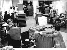
The city is known for its traditional chair making trade , which took off in the 17th century and flourished in the 19th century with numerous companies and workshops in Rabenau, Oelsa and the surrounding area. In the GDR , Rabenau remained an essential center of the national seating and period furniture industry, despite the nationalization of the craft businesses. Since the fall of the Wall , the local importance of this branch has declined due to international competition and traditional craft businesses have had to close. Nevertheless, the furniture factory is the city's largest employer.
Railway connection
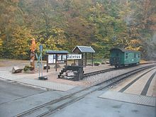
In 1882 the Weißeritztalbahn was opened, a narrow-gauge railway from Hainsberg near Dresden to Kipsdorf in the Ore Mountains. The Rabenau train station and the Spechtritz stop are located on the territory of the city of Rabenau . This railway was designed as a typical Saxon narrow-gauge railway with a gauge of 750 millimeters and is today the longest-serving narrow-gauge railway in Germany. The Rabenau train station was wrested from the rock with great effort. Until the early 1970s, the station building was above the Weißeritz, then it was demolished. Freight traffic in particular was of great importance for the timber industry; in Rabenau there was a multi-track loading line and a goods floor. There was also a water crane that was fed from a water tank in the rock above the station. The water crane was destroyed in an accident in the early 1970s. The loading line was no longer used around the same period. A warehouse was later built on the site of Ladestrasse, which was later demolished.
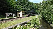
The route was largely destroyed by the floods in August 2002 . In 2004, management of the line was transferred from Deutsche Bahn to the Sächsische Dampfeisenbahngesellschaft , which began to rebuild the line in 2007. The goods floor in Rabenau was demolished. At the Spechtritz stop, the damaged railroader's house and the waiting room were demolished. The waiting hall was rebuilt true to the original. In December 2008 the line to Dippoldiswalde went back into operation.
Culture and sights
- see also: List of cultural monuments in Rabenau
school
The school building, which can be seen from afar , was built in 1929 in contemporary architecture by Oswin Hempel at one of the highest points in the town . The three-storey, U-shaped building is partly made of clinker brick and is crowned by a small clock tower. The facility includes a caretaker's building. The school originally had 18 classrooms and was the central school for Rabenau and the surrounding districts. In the GDR it was named after the Dresden worker athlete and Nazi opponent Heinz Steyer (1909-1944) and was a two-tier ten-class polytechnic high school . From 1992 to 2005 it was a state middle school . Due to the declining number of pupils, the district council and the Ministry of Culture decided to close the state secondary school in Rabenau in summer 2005. By resolution of the Rabenau City Council, the school building was given to the private school authority BGGS Sachsen gGmbH (today DPFA-Regenbogenschulen), which has been running the Free Middle School and Free High School Rabenau there since the 2005/2006 school year . According to the Saxon School Act, the school functions as a state-recognized substitute school . In the 2007/2008 school year, the same school authority opened a single-tier elementary school in the Rabenau school building; a grammar school is being established (as of 2017).
The next state primary school is in the district of Oelsa, the next state high school and the next state high school in Freital .
museum
The German Chair Making Museum was founded in 1922 as a local museum for the town of Rabenau. It shows interesting facts from the local history and gives an insight into the more than 400-year-old handicraft tradition. It is the only specialist museum of its kind in Germany. By integrating the museum workshop of master craftsman Kurt Aehlig (1900–2001), the exhibition area was expanded considerably in 2005.
church
A first church was located in the castle as a castle chapel. After a fire, a new chapel was built in 1487. The current structure of the Evangelical Lutheran Church " St. Egidien " has been standing since 1642, after the previous church building burned down partly during the occupation by Swedish troops in the Thirty Years' War . The Sunday after the exaltation of the cross (September 14th) is regarded as the parish festival in Rabenau . Parts of the previous church building can still be found in the choir today .
Worth seeing is the tombstone of the son Casper of the lord of the castle Heinrich von Miltitz, who died in 1559 as a child, in the nave and the former altarpiece hanging over the main entrance, which was donated in 1647 by the Eckersdorfer Vorwerk owner Caspar Barthel. The boxes built into the choir room in 1882 were removed in 1924. Today's organ was built in 1993 by Jehmlich Orgelbau Dresden .
The parish is part of the parish Kreischa-Seifersdorf and belongs to the church district Dippoldiswalde . The next Catholic church is in Freital .
town hall
The town hall was built in 1892 on the east side of the market square. The three-storey yellow brick building with a small tower was renovated in the early 1990s and now houses the city administration and the council cellar . In front of it is the Stuhlbau-Brunnen on the market square.
Surroundings
Well-known excursion destinations are the Rabenauer Grund with the Weißeritztalbahn, the Lerchenberg , the Götzenbüschchen , the Malter dam and the Dippoldiswalder Heide with the ruins of the Barbarakapelle from the 16th century, the Einsiedlerfelsen and the Heidemühlenteich .
Natural monuments
Cotta square
The three winter linden trees are on the road to Spechtritz in the Buchwald. They are under nature protection. The linden trees were planted in honor of Heinrich von Cotta , who often stayed here with his forest students.
Parish linden tree
The parish linden tree ⊙ is a winter linden tree ( Tilia cordata ) and is located at the intersection of Marktsteig / Weisse Strasse in the middle of the Rabenauer Pfarrhufe.
Personalities
- Karl von Miltitz (1490–1529), papal nuncio
- Ernst von Miltitz zu Batzdorf und Siebeneichen (1495 / 1498–1555), Saxon Oberhofmarschall , born in Rabenau
- Anton Bodenhäuser (1587–1673), pastor of Rabenau from 1617, hid the Rabenau residents during the Swedish invasion in 1639 at the Predigtstuhl in Rabenauer Grund
- Johann Samuel Adami (1638–1713), theologian, writer and linguist
- Johann Christoph Knöffel (1686–1752), Saxon master builder, born in Oelsa
- Georg Friedrich Hammer (1694–1751), pastor
- (Alfred) Fred Otto (1883–1944), architect, city planner in Chemnitz , born in Rabenau
- Willy Wirthgen (1904–1944), resistance fighter against fascism, born in Rabenau
- Ruth Lange (1915–2008), opera singer (alto; mezzo-soprano), born in Rabenau
- Ingeborg Lahl-Grimmer (1926–1989), painter, lived in Rabenau
- Armin Münch (1930–2013), painter and graphic artist, born in Rabenau
- Cornelius Schnauber (1939–2014), literary scholar, author, grew up in Rabenau
- Christoph Rueger (1942–2020), book and radio author, musicologist and professor of music theory and composition
- Horand Friedrich (* 1943), chamber singer (bass), lives in Rabenau
- Hans-Jürgen Kreische (* 1947), national soccer player of the GDR, grew up in Rabenau
- Arila Siegert (* 1953), ballet dancer, director and choreographer, grew up in Rabenau
- Daniel Rosin (* 1980), professional soccer player, grew up in Rabenau
Partner locations
The eponymous Rabenau in Hesse is a partner municipality . The district of Oelsa maintains a partnership with Rangendingen in the Swabian Alb .
Trivia
In 1992 Rabenau was as "Landwitz" with the Weißeritztalbahn and the Rabenauer Mühle filming location for the film Go Trabi Go 2 - That was the wild east .
literature
- Cornelius Gurlitt : Rabenau. In: Descriptive representation of the older architectural and art monuments of the Kingdom of Saxony. 24. Issue: Amtshauptmannschaft Dresden-Altstadt (Land) . CC Meinhold, Dresden 1904, p. 110.
- Dietrich Noack: Rabenau. A walk through the history of the chair-making town and its districts . Rabenau 2010
- Beautification and Mountain Association Rabenau: Guide through Rabenau and its surroundings . Verlag Huhle, Dresden 1901 ( digitized version )
Web links
- Official website of Rabenau
- German chair making museum with home collection of the city of Rabenau
- Radio feature, 30min. about the Nikolai chair and its manufacture in Rabenau, to listen to on MDR KULTUR
Individual evidence
- ↑ Population of the Free State of Saxony by municipalities on December 31, 2019 ( help on this ).
- ^ Population, households, families as well as buildings and apartments on May 9, 2011 according to parts of the municipality. (PDF; 236 kB) In: Kleinräumiges Gemeindeblatt Census 2011. State Statistical Office Saxony, accessed on October 31, 2015 .
- ^ Rabenau in the Digital Historical Directory of Saxony
- ↑ Vincenz Kaiser: On the colonization and formation of rule of the Burgraves of Dohna in the Weißeritz area , unpublished manuscript, Dresden 2007
- ↑ Mayor Paul: Development of the Talblick residential area - mining in Rabenau? In: Ortsblatt Rabenau 07/12/2019. City of Rabenau, accessed on April 13, 2020 .
- ↑ Dresden State Archives (ed.): Friedrich Gottlob Rost, house owner in Rabenau, against Theodore Amalie von Baumann, b. Querfurth, owner of the Rabenau estate, because of a sewer water . 10046 Office Dippoldiswalde, No. 0141 , 1835.
- ↑ Disarmed . Thüringische Landeszeitung, November 13, 2013, p. 1
- ↑ [1]
- ↑ Georg Friedrich Hammer (1742): Renewed Andencken of the Rabenauischen Pastorum from 1539 to 1741 together with an appendix of their Pastorum zu Höckendorf, Seyfersdorf, Somsdorf, Ruppendorf and Possendorf, on the happy return from England, Holland, etc.
- ^ Anton Bodenhäuser (1587–1673) in the parish book of Saxony.


