
Ostrov nad Ohří
| Ostrov | |||||
|---|---|---|---|---|---|
|
|||||
| Basic data | |||||
| State : |
|
||||
| Region : | Karlovarský kraj | ||||
| District : | Karlovy Vary | ||||
| Area : | 5042 ha | ||||
| Geographic location : | 50 ° 18 ' N , 12 ° 57' E | ||||
| Height: | 398 m nm | ||||
| Residents : | 16,731 (Jan 1, 2019) | ||||
| Postal code : | 363 01 | ||||
| License plate : | K | ||||
| traffic | |||||
| Railway connection: | Chomutov – Cheb | ||||
| structure | |||||
| Status: | city | ||||
| Districts: | 12 | ||||
| administration | |||||
| Mayor : | Josef Železný (as of 2017) | ||||
| Address: | Lidická 1201 363 01 Ostrov |
||||
| Municipality number: | 555428 | ||||
| Website : | www.ostrov.cz | ||||
| Location of Ostrov in the Karlovy Vary district | |||||

|
|||||


Ostrov ( German Schlackenwerth ) is a town in Okres Karlovy Vary in Karlovarský kraj in the Czech Republic .
The city consists of two relatively self-sufficient parts: the old Schlackenwerth, with the historic town center and a large palace and park , and a north-east of it, newly created in the 1950s, a model socialist town in which the vast majority of the population lives.
geography
location
The city is located in northern western Bohemia at the confluence of the Jáchymovský potok (Weseritz) in the Bystřice (Wistritz).
City structure
Districts
- Arnoldov (Arletzgrün)
- Dolní Žďár (Under Fire)
- Hanušov (light green)
- Hluboký (Tiefenbach)
- Horní Žďár (Upper Brand)
- Kfely (Gfell)
- Květnová (Permes Green)
- Liticov (Lititzau)
- Maroltov (Marletzgrün)
- Mořičov (Möritschau)
- Ostrov (Schlackenwerth)
- Vykmanov (willow green)
Basic settlement units
- Arnoldov
- Borek (Heidles)
- Dolní Žďár
- Družba
- Hanušov
- Hluboký
- Horní Žďár
- Kfely
- Květnová
- Liticov
- Maroltov
- Mořičov
- Mořičovská
- Nad nádražím
- Ostrov-střed
- Sídliště-jih
- U domu culture
- U Škodovky
- Vykmanov
- Zámecký park
Cadastral districts
- Arnoldov
- Dolní Žďár u Ostrova
- Hanušov
- Hluboký
- Horní Žďár u Ostrova
- Kfely u Ostrova
- Květnová
- Maroltov
- Mořičov
- Ostrov nad Ohří
- Vykmanov u Ostrova
Neighboring places
| Merklín (Merkelsgrün) | Jáchymov (St. Joachimsthal) | Krásný Les (Schönwald) |
| Hroznětín (Lichtenstadt) |
.svg)
|
Vojkovice (Wickwitz) |
| Hájek (grass green) | Kyselka (Gießhübl-Sauerbrunn) | Velichov (Welchau) |

history
Middle Ages and Modern Times
.jpg)
The first, not entirely certain, mention of the city took place in 1207; As early as 1226, Schlackenwerth was listed among the possessions of the von Hrabischitz family as the founding of Slaukos the Great . The name of the town suggests mining. As a royal city , Schlackenwerth was on the trade route from Prague to Eger and thus became rich through customs revenue.
After the Battle of the White Mountain in 1623, Schlackenwerth went to Julius Heinrich von Sachsen-Lauenburg , a confidante of Wallenstein and an imperial field marshal. He had a residence built here; Bohuslav Balbín once called it “The eighth wonder of the world ”. In 1656 he succeeded his brother as Duke of Saxony-Lauenburg .
Until 1848 Schlackenwerth belonged to the rule of the same name. Schlackenwerth was a fiefdom of the Margraves of Baden from 1691 to 1787 , after Margrave Ludwig Wilhelm von Baden married Princess Franziska Sibylla Augusta von Sachsen-Lauenburg, 20 years his junior, on March 27, 1690 .
Franziska Sibylla Augusta worked as a builder early on. In Schlackenwerth, together with Ludwig Wilhelm, she built the White Palace , which was completed in 1697, in 1691 . This was a three-winged complex based on Viennese and Prague models, which - located in the middle of a park - was adapted to Bohemian conditions. The builder was Johann Michael Sock.
In 1709, in Schlackenwerth, she had a chapel built based on the model of the Maria Einsiedeln chapel in Switzerland to thank her son Ludwig Georg for finding the language . Another copy of this chapel was made in Rastatt in 1715 .
The inhabitants of the city and the entire Elbogen district were German-speaking. In the 1900 census, the language of the local population was exclusively German.
World wars
After the First World War, Schlackenwerth was added to the newly created Czechoslovakia . In 1938, the city fell due to the Munich agreement as part of the Sudetenland to the German Reich and was until 1945 the district Karlovy Vary , Region of Eger , in the Reich District of Sudetenland . The town of Schlackenwerth had 2958 inhabitants on December 1, 1930, and 2847 on May 17, 1939.
From May 17, 1943 to April 19 or 20, 1945, there was a subcamp of the Flossenbürg concentration camp in the village , whose 120 prisoners had to do forced labor for the SS at Schlackenwerth Castle.
After the end of World War II , the German population was largely expelled in 1945 and replaced by Czechs, Slovaks and Roma from Slovakia. On May 22, 1947, 1,893 residents were counted.
Stalinist model city
During the post-war years, a planned town was built northeast of the old, relatively small historic town center , based on the same principle as Eisenhüttenstadt . Since workers for uranium ore mining were to be settled in Jáchymov , attempts were made to make the new city attractive on the one hand and to pay homage to the ruling regime on the other. A Stalinist model city emerged in socialist realism , in the moderate confectioner style , with boulevards and large squares. A large cultural center with a theater, cinema and air raid shelter was built on the central place of peace . Several schools and three health stations were built.
In 1958 the USSR stopped mining uranium ore in Jachymov. A Škoda plant for trolleybuses, which was closed in 2004, was relocated to replace the jobs that were lost .
- The new socialist city

boulevard

detail

View over the city center to the Ore Mountains

Expansion of the new city after the Stalinist era

.jpg)


Demographics
Until 1945 Schlackenwerth was predominantly settled by German Bohemia , which were expelled.
| year | Residents | Remarks |
|---|---|---|
| 1785 | k. A. | 218 houses |
| 1830 | 1,050 | in 238 houses |
| 1847 | 1,276 | in 238 houses |
| 1869 | 1,774 | |
| 1880 | 2,272 | |
| 1890 | 2,463 | |
| 1900 | 2,460 | German residents |
| 1910 | 2,603 | |
| 1921 | 2,573 | including 2,478 Germans |
| 1930 | 2,958 | |
| 1939 | 2,852 |
| year | 1950 | 1961 1 | 1970 2 | 1980 3 | 1991 3 | 2001 3 | 2011 3 |
| Residents | 2,746 | 16,556 | 18,145 | 19,450 | 17,872 | 17,451 | 17,859 |
Attractions
Historic town center

- The historic center of the city is the Alte Platz, where the plague column from 1685, the town hall from 1599 and a city gate are located.
- The old town hall on the Alter Platz, originally Gothic, was rebuilt after a fire in the Renaissance style and later in the neo-Gothic style.
- The Romanesque cemetery church of St. Jakob from the 13th century is one of the oldest architectural monuments in the Karlovy Vary region . Its construction was supported by Bohuslav I. von Hrabischitz, among others . The single-nave building with a square choir was built from rubble stones. The inner facade is kept simple, not structured and not decorated. The original windows have been given a new look through numerous alterations, while the main portal has been retained. The main nave is flat, the choir with a semicircular late Gothic triumphal arch . The thick walls suggest that there used to be a tower in the east. The church was consecrated in 1226.
- The Gothic church of St. Michael near the market square was mentioned as early as 1384. It is single-nave and has a six-sided tower. Inside it is richly decorated with a remarkable vault.
Castles and Park
- The Ostrov castle also includes two wings of the Prince's Palace and a large park received, which also houses the 1674-1683 built baroque pleasure palace ( White Castle , Letohrádek ) is (architects: Abraham Leuthner and Christoph Dientzenhofer ). Today there is a branch of the Karlovy Vary Art Gallery.
- The area of the Piarist monastery from the 17th and 18th centuries: family grave chapel of St. Anna, monastery church of the Annunciation, Piarist high school, chapel of St. Florian and the chapel of Maria Einsiedeln.
- Castles and Park

City Palace

dto.
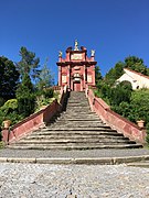
Maria Einsiedeln

Castle Park
.jpg)

.jpg)


The new socialist city
- The center of the Stalinist model town in the confectioner's style , with boulevards and large squares, is extraordinary .
- The house of culture is open to the public, with perfectly preserved interiors, with large paintings.
- The Red Tower of Death on the site of the former Škoda plant commemorates the suffering of the political prisoners who had to work in the uranium mines in Jachymov and in ore processing.
For pictures see: Section Stalinist Model City
Parish places
Arletzgrün, Fuchsloch, Gfell, Grasengrün, Heidles, Honnersgrün, Lititzau, Marletzgrün, Möritschau, Neudau, Neudörfel, Ober Brand, Permesgrün, Pfaffengrün, Tiefenbach, Unter Brand, Weidmesgrün
Town twinning
The town of Ostrov has relationships with the following cities twinning :
Personalities
sons and daughters of the town
- Johann Wulfing von Schlackenwerth († 1324), Bishop of Brixen and later Prince-Bishop of Bamberg and Freising
- Stefan Schlick (1487–1526), nobleman and mining entrepreneur
- Joachim Andreas von Schlick (1569–1621), leader of the Protestant estates in Bohemia
- Paul Mönch (1582–1637), Lutheran clergyman
- Conrad Max Süßner (1652 - after 1696), sculptor
- Jeremias Süssner (1653–1690), sculptor and master builder
- Johann Caspar Ferdinand Fischer (1662–1746), court conductor of the Margraves of Baden
- Rudolf Keller (1875–1964), American biochemist, publicist and publisher
- Fritz Keller (1878–1938), Austrian architect
- Bernd von Hoffmann (1941–2011), lawyer
- Siegfried Lehrl (* 1943), psychologist
- Horst Siegl (* 1969), soccer player
- Petr Maděra (* 1970), writer
- Lukáš Bauer (* 1977), cross-country skier
- Martin Čechman (* 1998), track cyclist
Worked in place
- Ivan Blecha (* 1957), head of the Philosophy Institute at the University of Olomouc; attended the local high school
- Bonifác Buzek (1788–1839), priest, educator, philosopher and educator; taught at the local high school
- Josef Loschmidt (1821–1895), physicist and chemist; attended school here from 1833 to 1837
literature
- Josef Hubatschek: Schlackenwerth. The bohemian home of the Baden margravine Franziska Sibylla Augusta. A book of memories. Brönner & Daentler, Eichstätt 1972.
- Josef Kühnl: History of the town of Schlackenwerth, the former residence of the Dukes of Lauenburg and the Margraves of Baden. With the environment in mind. Stadtgemeinde Schlackenwerth, Schlackenwerth 1923, (reprint. Arbeitsgemeinschaft Stadt Schlackenwerth, Rastatt et al. 1976).
- Jiří Linhart: Karlovarsko krok za krokem. Výlety do okolí Karlových Varů. Promenáda, Carlsbad 1996, ISBN 80-238-0276-3 .
- Vinzenz Uhl: Castles and palaces of the Ore Mountains and Egertal. Kaaden, 1935. (Schlackenwerth Castle)
Web links
- Ostrov city website (Czech)
Individual evidence
- ↑ Český statistický úřad - The population of the Czech municipalities as of January 1, 2019 (PDF; 7.4 MiB)
- ↑ http://www.uir.cz/casti-obce-obec/555428/Obec-Ostrov
- ↑ http://www.uir.cz/zsj-obec/555428/Obec-Ostrov
- ↑ http://www.uir.cz/katastralni-uzemi-obec/555428/Obec-Ostrov
- ↑ Johann Gottfried Sommer: The Kingdom of Bohemia . Elbogen circle. tape 15 . JG Calve, Prague 1847, p. 4, 170 ( google.de [accessed on January 15, 2018]).
- ^ Community encyclopedia of the kingdoms and countries represented in the Imperial Council. Volume IX: Bohemia. Edited from the results of the census of December 31, 1900. KK Central Statistical Commission, 1904, p. 290 , accessed on January 15, 2018 .
- ↑ Website of the Flossenbürg Concentration Camp Memorial ( Memento of the original from July 7, 2016 in the Internet Archive ) Info: The archive link was inserted automatically and has not yet been checked. Please check the original and archive link according to the instructions and then remove this notice. Retrieved July 6, 2016
- ^ Rudolf M. Wlaschek: Jews in Böhmen . Munich: Oldenbourg, 1990, p. 153
- ^ History of the Roma in the Czech Republic. Retrieved January 15, 2018 .
- ↑ Jaroslaus Schaller : Topography of the Kingdom of Bohemia . Volume 2: Ellbogner Kreis , Prague 1785, pp. 67-70, item 1) .
- ↑ Yearbooks of the Bohemian Museum of Natural and Regional Studies, History, Art and Literature . Volume 2, Prague 1831, p. 200, paragraph 25).
- ↑ Johann Gottfried Sommer : The Kingdom of Bohemia . Volume 15: Elbogner Kreis , Prague 1847, p. 95.
- ^ Meyer's Large Conversational Lexicon . 6th edition, Volume 17, Leipzig and Vienna 1909, pp. 819–820 .
- ^ Sudetenland Genealogy Network
- ^ A b Michael Rademacher: German administrative history from the unification of the empire in 1871 to the reunification in 1990. City and district of Karlsbad. (Online material for the dissertation, Osnabrück 2006).
- ↑ Historický lexikon obcí České republiky - 1869-2015. Český statistický úřad, December 18, 2015, accessed on February 16, 2016 (Czech).
- ^ Wenzl Sommer: Brief history of the town of Schlackenwerth in connection with the Piarist College. Self-published, Schlackenwerth 1866, ( digitized version ).