
Xalapa
| Xalapa | ||
|---|---|---|
|
Coordinates: 19 ° 32 ′ N , 96 ° 56 ′ W Xalapa on the map of Veracruz
|
||
| Basic data | ||
| Country | Mexico | |
| State | Veracruz | |
| Municipio | Xalapa | |
| City foundation | 1791 | |
| Residents | 502,151 (2017) | |
| - in the metropolitan area | approx 700,000 | |
| City insignia | ||
 |
||
| Detailed data | ||
| surface | 124.4 km 2 | |
| Population density | 3,681.7 inhabitants / km 2 | |
| height | 1440 m | |
| Post Code | 91000-91198 | |
| prefix | 228 | |
| Website | ||
 |
||

Xalapa [ xaˈlapa ] (officially Xalapa-Enríquez [ xaˈlapa enˈrikes ]; formerly also written Jalapa ) is the capital of the Mexican state of Veracruz . It is also the administrative seat of the municipality of the same name , with whose area the city is practically congruent.
geography
Xalapa is located in the center of the state of Veracruz , which runs along the Gulf of Mexico , around 100 kilometers northwest of the port of Veracruz and 350 kilometers east of Mexico City . The area of the city is not statistically recorded, but the almost congruent municipality covers 124.4 km². The city is located at an altitude of 1100 to 1600 meters above sea level.
topography
Topographically, Xalapa is located at the transition between the mountains of the Mexican Sierra Nevada and the coast of Veracruz to the Gulf of Mexico . Accordingly, various volcanoes to the west such as the Cofre de Perote (4200 meters above sea level) limit the view from the city. The Pico de Orizaba , with over 5300 meters the highest mountain in Mexico, is clearly visible from the urban area of Xalapas towards the southwest in good weather. To the north, the area is bounded by the foothills of the Eje Neovolcánico Transversal , which extend to the coast .
Due to its location at the foot of the above-mentioned elevations, Xalapa has significant height differences throughout the city. The urban zone begins in the southeast at an altitude of around 1100 meters. The actual city center with the administrative seat of the state is already at around 1400 meters above sea level. Some of the northern outskirts of the city reach a height of around 1,600 meters above sea level.
At the same time, various valleys traverse the urban areas of the city, so that streets are sometimes steep or designed according to the topography. In some places, stairs run through the quarters. Larger streets like Lázaro Cárdenas , the Arco Sur, Murillo Vidal , the Avenida Araucarias or the Carretera Antigua a Coatepec are curved and built according to the surroundings. At the same time, the differences in height also allow views from the built-up area. For example, from Parque Juárez in the city center, both the Cofre de Perote and the uppermost glaciated Pico de Orizaba are visible.
Within the city limits, two hills tower over the urban area. The extinct and now forested volcano Macuiltépetl (also sometimes called Macuiltépec ) is 1600 meters above sea level, almost 100 meters higher than the surrounding quarters and, thanks to its shape, is a symbol of the city. There is a small museum at the top. The elevation is declared as a nature reserve ( Parque Ecológico ). Further north there is another park, the Cerro de la Galaxia , which overlooks the surrounding area by around 50 meters.
Hydrography
.jpg)
Even if the city is not on an obvious body of water, numerous streams arise in the vicinity of Xalapa. Coming northwest of Xalapa, the Río Sedeño flows around the city in the north and crosses the bypass under the Viaducto Puente Xalapa . The Río Sordo has its source near the Río Sedeño , but flows around the urban area to the west and drains the city to the southwest. The water of the Río Sordo eventually flows as Río La Antigua near José Cardel in the Gulf of Mexico .
After all, various lakes, including artificial ones, can be found in Xalapa's urban area. The best known are certainly Los Lagos in the center in the immediate vicinity of the student area and the campus of the Universidad Veracruzana as well as Los Lagos de las Animas in the southeast of the city. East of Xalapa is also the Laguna del Castillo.
Other watercourses than those mentioned are mostly underground and therefore not visible.
climate
The climate of Xalapa is stated by official sources as predominantly temperate and humid, which corresponds to a Cfa or a Cfb on the Köppen climate classification .
| Xalapa Enríquez (Las Animas) | ||||||||||||||||||||||||||||||||||||||||||||||||
|---|---|---|---|---|---|---|---|---|---|---|---|---|---|---|---|---|---|---|---|---|---|---|---|---|---|---|---|---|---|---|---|---|---|---|---|---|---|---|---|---|---|---|---|---|---|---|---|---|
| Climate diagram | ||||||||||||||||||||||||||||||||||||||||||||||||
| ||||||||||||||||||||||||||||||||||||||||||||||||
|
Climate diagram Xalapa (Las Animas)
Source: Data from the Servicio Meteorológico Nacional (1981–2010) for the Xalapa-Las Animas weather station (19 ° 30'00 "N; 96 ° 53'06" W)
|
||||||||||||||||||||||||||||||||||||||||||||||||||||||||||||||||||||||||||||||||||||||||||||||||||||||||||||||||||||||||
Averages
Xalapa occupies a transition position due to its location in the transition between the semi-arid-temperate highlands and the humid-warm coastal area. Accordingly, the weather is often changeable: sunny in the morning, cloudy in the course of the afternoon. The temperatures also vary between night and day. Nevertheless, the temperature does not fluctuate much all year round with an average annual temperature of around 20 ° C.
The warmer season in Xalapa tends to start in April and peak as early as May, when the average high temperature exceeds 28 ° C and the daily minimum does not drop below 15 ° C. The hottest month in Xalapa is May, because there is not enough moisture to dampen the already strong sunlight. In midsummer, the daytime temperature feels warmer, as the heat and moisture combine to create a muggy mixture. So from midday onwards, haze often forms. In the evening, heavy rains and thunderstorms are possible, which can also make parts of the road impassable for a short time.
The cooler season is late December, January and February with an average low of 11 ° C and an average high of 22 ° C. In winter it is possible that the temperature drops below 5 ° C at night. With the fog appearing in the evening, it feels like freezing temperatures - but real freezing temperatures are seldom or never reached in the urban area. During the day, the temperature then rises to around 20 ° C.
Precipitation is minimal during the cooler winter months, with only around 50 mm in December, January and February and a monthly average of just over 40 mm in March. Very early in the morning, Xalapa is often wrapped in fog, which gives the city a mystical mountain atmosphere. All precipitation in Xalapa is in liquid form. There is only snow in the surrounding mountains and on the Cofre de Perote on cold winter days . However, this does not last long and often disappears again during the day. The greatest rainfall occurs in the summer months: especially in June when the average rainfall reaches 250–300 mm and remains relatively high until mid-September. The average rainfall adds up to around 1,300–1,400 millimeters per year. From time to time Xalapa is also hit by hurricanes , which quickly increase the measured amount of rain. Accordingly, the records can be impressive (see below).
The measured values can also vary within the city. The following weather station is located in the northwestern part of Briones, around 7 kilometers as the crow flies from the other weather station outside of the built-up area. The lower night temperatures as well as the higher precipitation are clearly visible, due to the lack of buildings and the topographical conditions, which are often very local precipitation amounts.
|
Briones climate diagram
Source: Data from the Servicio Meteorológico Nacional (1981-2010) for the Briones weather station (19 ° 30'30 "N 96 ° 56'58" W)
|
||||||||||||||||||||||||||||||||||||||||||||||||||||||||||||||||||||||||||||||||||||||||||||||||||||||||||||||||||||||||
The transition from the hot and humid zone around Xalapa to the dry highlands near Perote is also worth mentioning . The area around Las Vigas de Ramírez near Perote is only 30 minutes away by car and 1000 meters higher than Xalapa. In this way, the annual rainfall decreases by 60 percent (Perote: 532 mm / year)! It is precisely this transition that triggers a weather phenomenon in Xalapa. Cold and dry mountain air meets humid and hot sea air from Veracruz in the region of Xalapa and immediately condenses. The result is the fog that often occurs .
Records
The highest temperature since measurements began in 1953 was measured on May 8, 1973 at 39.5 ° C at the Xalapa-Las Animas weather station. These temperatures were almost reached again in June 2009 and in September and October 2012. According to the Servicio Meteorológico Nacional, the lowest measured temperature is 0.0 ° C (November 17, 1970).
Record rainfall is rarely recorded in Xalapa. In the summer months, local heat thunderstorms often drop large amounts of rain. But these are not the main cause of records. Rather, these are the hurricanes . On a single day, September 21, 1974, 176.2 liters per square meter fell at a weather station that has now been closed. 175 liters were also measured the day before at the Xalapa-Las Animas weather station. The trigger for these heavy rains was Hurricane Fifi , which moved from Belize via Guatemala to southern Mexico. It is still considered to be extremely rainy today, claimed numerous lives in Honduras and caused widespread flooding. In Xalapa, the hurricane was just a tropical depression, but it brought record amounts of rain with it. The September therefore 1974 will go down in history as Xalapas rain richest month.
Negative precipitation records have already been registered in numerous months without any precipitation.
Series of measurements from the Xalapa-Las Animas weather station from 1953 to 2012 were taken into account for the records.
Urban areas
Apart from the Zona Centro, Xalapa is divided into Colonias, Unidades and Fraccionamientos , although the names and boundaries are not always clear even to the city's residents. Postal codes between 91000 and 91198 are assigned for all quarters, with the center bearing 91000.
In the past few decades the city has developed in spurts in all directions with the construction of new colonias and fracionamientos . The city grew particularly strongly in the second half of the 20th century in a north-east direction up to the Río Sedeño, where some district streets have not yet been paved to this day . In the meantime, the city in the north has merged seamlessly with Banderilla. In the west, too, the urban area passes directly into the agglomeration of Guadelupe Victoria.

Better known areas within the city include the more upscale Las Animas neighborhood . It is a region with numerous single-family houses surrounded by trees, which often have a fenced-in area and a green driveway.
The city is currently developing south of it in the area of Monte Magno and in the east south of Avenida Chedraui Caram in the direction of the village of El Castillo. It is only a matter of years before the city grows together with the neighboring communities in this area as well.
Neighboring communities
Xalapa as a city occupies around half of the area and over 90 percent of the population, a large part of the municipality of the same name, Xalapa . Some of the neighboring towns of the city are therefore no longer in the same municipality. The largest neighboring towns of the city are as follows (in brackets the municipality):
| Tlalnehuayocan ( Tlalnehuayocan ) | Banderilla ( banderilla ) | La Concepción ( Jilotepec ) |
| Guadelupe Victoria ( Tlalnehuayocan ) |
.svg)
|
El Castillo ( Xalapa ) |
| Coatepec ( Coatepec ) | Pacho Viejo ( Coatepec ) | Colonia Santa Bárbara / Lomas Verdes ( Xalapa ) |
In addition, there are numerous smaller settlements with fewer than 250 inhabitants around Xalapa.
history

Beginnings of the place
The exact date of Xalapa's founding is unknown. According to the historian Rivera Cambas , this took place in 1313, at a time when Tenochtitlan was also founded. Historians still argue about who the first residents of Xalapa were. It is believed by some that the Totonaks settled in the north on the slopes of the Macuiltépetl , where remains of them were also found. However, others argue that the Toltec people originally lived there before moving to the Yucatán Peninsula .
What is certain, however, is that Xalapa was ultimately formed from the settlement of several peoples. In the 14th century, four indigenous groups independently founded a small town. These places were:
- Xallitic (in the sand), founded by the Totonaks in the north
- Techacapan (river that rises in the stones), founded by the Chichimecs in the east
- Tecuanapan (river of wild animals), founded by the Toltecs in the northeast
- Tlalnecapan (River of the Lianas), founded by the Teochichimeks in the southwest
In 1457 the four places fell under the Aztec Empire under Moctezuma Ilhuicamina , the fifth Aztec king, when he advanced into the region of Cotaxtla and Zempoala . The previously four independent places were grouped under the name Xallapan . From then on, Xallapan remained under Aztec rule, some of the names of the former localities still exist today as quarter names.

Arrival of Hernán Cortés
Xallapan was still under the rule of the Aztecs when Hernán Cortés reached old Xalapa on August 17, 1519 on his campaign against Tenochtitlan (now Mexico City ). The Conquistador Hernán Cortés ordered after his invasion to build a Catholic church for the village. His request was met in 1641 with the previous building of the Catedral Metropolitana de Xalapa .
Even earlier, after the conquest of Mexico was completed, the Spanish religious sought to convert the local population to the Christian religion. For this purpose in 1555 was in Xalapa Convento de San Francisco (Convent of San Francisco) on the territory of modern Parque Juárez founded . From 1560 onwards numerous missionaries emerged from the convent who converted Coatepec and other surrounding villages.
The Spaniards subsequently destroyed the existing temples and replaced them with churches. This is how the Catholic churches El Calvario in Xallitic , San José de la Laguna in Techacapan and Santiago in Tlalnecapan were created . In addition, the precursor of today's cathedral ( Catedral Metropolitana de Xalapa ) was built independently in the center , which is now also the cathedral of the Archdiocese of Jalapa .
With the conquest of the city by the Spaniards, the population increased. At that time, Xalapa represented a stop on the way from Mexico City to the port of Veracruz . With the opening of the route via Orizaba , Xalapa lost its importance as a transit point. As a result, the population remained practically the same in the 17th century.
growth
This changed in the 18th century. From 1720 the Feria de Xalapa (Xalapa fair) was organized regularly , which brought the city an influx of traders and sellers. As a result, more and more families of Spanish origin settled in the city. In 1760 the population of 1,000 was exceeded.
As a result, Xalapa developed more and more into an important center for trade and culture. On May 18, 1784, José María Alfaro , actually responsible for repairing the clock in Xalapa Cathedral, raised the first balloon on the American continent. It took off from Parque Los Berros before the wind carried it to Coatepec . It reached a maximum height of 800 meters above ground and covered around nine kilometers before landing. This happened around six months after the first successful balloon flight in Europe by the Montgolfier brothers . Today a street in the center of Xalapa is named after Alfaro.
With the growth of the place, Xalapa was finally named a city under Spanish law ( villa) on December 18, 1791 by Charles IV . The place received the coat of arms that is still valid today.
In 1804 the German naturalist Alexander von Humboldt reached Xalapa and named it the city of flowers . To this day, this or a variation of it ( "Xalapa florece!" ) Is the city's slogan.
Mexican independence and capital
At the beginning of the 19th century, Xalapa became the scene of political events that can be assigned to the forerunners of Mexican independence . The politician Diego Leño from Xalapa advised Francisco Primo de Verdad y Ramos and Juan Francisco Azcárate y Ledesma , who, as spokesmen, tried in 1808, together with the Viceroy of New Spain , José de Iturrigaray , to set up a government in Mexico City that was independent of Spain . As a result of events, Iturrigaray was removed from office. Diego Leño hosted the deposed Iturrigaray on his way to Fort San Juan de Ulúa in Xalapa.
On May 20, 1821, around four months before the enforcement of Mexican independence , Xalapa was attacked by the troops of Antonio López de Santa Anna , who at that time fought for the rebel leader Agustín de Iturbide and the separation from Spain. He forced the Spanish administrator in Xalapa, Juan Horbregoso , to cede the city to the independence movement.
Under the first President of Mexico, Guadalupe Victoria , the first government of the state of Veracruz was established in Xalapa on May 9, 1824. Xalapa thus became the capital of the state, if not yet definitely. A few years later, on November 29, 1830, Xalapa was officially declared a city. In 1843 Antonio María de Rivera founded the Colegio Nacional de Xalapa, the first school of its kind, which still exists today as a high school on Calle Benito Juárez .

American invasion and French intervention
During the Mexican-American War , North American troops under General Scott landed five kilometers south of the port of Veracruz on March 9, 1847, with the largest amphibious landing in the history of the US Navy. At the end of March, the port city could be captured. On April 8, a first group under David E. Twiggs advanced towards Xalapa with 2,600 men and, four days later, encountered a 12,000-man army under General Santa Anna in a skirmish . Two days later, Scott reached him with reinforcements that brought the army to 8,500 men. Scott and Santa Anna finally met on April 18, 1847 at the Battle of Cerro Gordo , where the Mexicans were crushed. The next day, on April 19, 1847, American troops marched into Xalapa.
The story of Ambrosio Alcalde and Antonio García, who opposed the American invasion, caused a particular stir. Alcalde and García were already fighting in the city of Veracruz at the end of March , but were captured and released when they renounced their weapons. Nevertheless, they fell into the hands of the Americans again shortly afterwards in a battle near Teocelo . Both were sentenced to death on November 24, 1847 by a council of war in Xalapa and shot behind the Iglesia San José . Today an obelisk commemorates the two soldiers on this very spot in today's Calle Alcalde y García .
Weakened by the chaos of war with America, French troops landed in Veracruz in early 1862. After various battles in Puebla and Orizaba , the French occupied Xalapa in November 1862. In 1865, the new Emperor of the Second Mexican Empire , Maximilian von Habsburg , stayed in Xalapa on his way from Veracruz to Mexico City. After Maximilian's death on June 19, 1867, after long negotiations, his preserved body was released for transport to Austria-Hungary . She arrived in Xalapa on November 27th and was laid out first in the barracks in San José and later in the Church of San José. The next day the body was shipped to Veracruz.
Progress under Juan de la Luz Enríquez

In the wake of the chaos of war, Xalapa had lost its status as the capital of the state of Veracruz in the meantime. In 1885, General Juan de la Luz Enríquez , governor of the state of Veracruz, restored the political rights of the capital to the city of Xalapa; a status that Orizaba had previously . The following year, Enríquez and Enrique Rébsamen, who came from Kreuzlingen , founded the Escuela Normal as the first teacher training college of its time. This training center revolutionized the Mexican education system under Rébsamen.
During the tenure of Enriquez, the building of the former convent of San Francisco was demolished and the Parque Juárez was built in the same place . In June 1890 the railway line from Xalapa via Coatepec to Teocelo was opened with the arrival of the first locomotive. This line should originally have run as far as Córdoba under the concession of Jalapa Railroad and Power Co. (JRR & PC) . The railway line, known as el piojito, was replaced by the bus in the 1940s. Only a locomotive monument in the Los Sauces district today reminds of the former railway line.
With the death of Juan de la Luz Enríquez on March 17, 1892, the renaming of Xalapas was initiated. By decree, the name of the city was supplemented with de Enríquez on March 30th .
Xalapa in modern times
Under the government of Governor Teodoro Dehesa Méndez , the Ferrocarril Interoceánico de México opened in 1901 . Xalapa got a rail connection to the sea. Nowadays, however, only goods are transported on the route. Nevertheless, the railway line still represents an important connection for the industry around Puebla to the port of Veracruz , along with the one via Orizaba .
In 1904, public lighting was introduced in the city.
On January 3, 1920, a strong earthquake shook the city. The earthquake with a magnitude of 6.4 on the Richter scale caused numerous damage, destroyed several buildings and cost around 650 lives.
During the Mexican Revolution , Xalapa fell into the hands of troops under the command of Guadalupe Sánchez in December 1923 . However, no other notable events during this phase of upheaval are known.
During the term of office of Governor Heriberto Jara Corona , the infrastructure in Xalapa was expanded. Among other things, the Estadio Xalapeño (Stadium of Xalapa) was fortified and opened in 1926 . Today it bears the nickname of the governor.

The government palace ( Palacio del Gobierno ) originally built in 1885 was expanded to the west in the 1930s. In 1956 the new town hall ( Palacio Municipal ) was also opened. On September 11, 1944, the Universidad Veracruzana was founded as a state university. It is currently training almost 60,000 students in numerous subjects and is one of the most renowned universities in Mexico.
In 1960 the Museo de Antropología de Xalapa (MAX) opened under Adolfo López Mateos in its current form. In 1986 they moved into the new staircase-like building in the north of the city. The museum is one of the most interesting archaeological museums in the country and houses - besides the museums of Mexico City and Villahermosa - the most extensive collection on the cultural field of the Olmecs .
In 1982/1983, the city's first shopping center, Plaza Crystal, was inaugurated. The center was the first such investment by the Chedraui food chain in real estate and shopping centers. It still exists today at the intersection of Lázaro Cárdenas and Calle Antonio Chedraui Caram.
In 1990, with the opening of the Central de Autobuses de Xalapa (CAXA), the urban bus stop for long-distance bus traffic was centralized. Before that, the respective bus companies had their own stops in the city.
In 2014, Veracruz hosted the Central American and Caribbean Games . Sports competitions were also held in Xalapa, with various sports facilities being renovated or rebuilt for this purpose.
Development of the name Xalapa
The name Xalapas developed over time: Originally the city was called Xallapan , a combination of the two Nahuatl words Xalli ( sand ) and Apan ( place of water ), which together can be roughly translated as "watercourse in the sand". During the colonial period, Xallapan was Hispanicized to Jalapa . In 1892 the city was officially renamed to Jalapa de Enríquez in honor of Juan de la Luz Enríquez (governor of the state of Veracruz from 1884 to 1892) . In 1978 Veracruz decreed the spelling with X , so the city was officially called Xalapa de Enríquez from then on . Today the name Xalapa is mostly used for the city . In official documents, the spelling Xalapa-Enríquez has spread to avoid confusion with the practically congruent Municipio Xalapa .

coat of arms
The coat of arms of the city of Xalapa shows a series of five hills in the middle, which, among other things, represent the extinct Macuiltépetl volcano in the city center of Xalapa. There is a bright star above the five hills, which is said to represent the city's friendly, peaceful and temperate climate. Around the center is a strip with the letters of Xalapa is alternating with the roots and flowers of the magic flower ( Mirabilis jalapa ), a plant which was estimated at that time in Europe for its medicinal properties. Finally, the lagoon and sand portray the village as it was in 1791.
In the upper part of the shield there are other elements, such as the helmet and the caduceus of Mercury as a symbol for trade between the nations of Europe and America. The cornucopia of Amaltheia with the flowers and fruits representing the abundance and beauty of the place.
The coat of arms was given to Xalapa by the Spanish King Charles IV on December 18, 1791 in Madrid . This happened at the request of Juan Vicente de Güemes , who was then viceroy of New Spain .
population
Population codes
In 2010, the city of Xalapa had 424,755 inhabitants, according to the INEGI census. Compared to 2005 this corresponds to a growth of 9.5 percent (2005: 387,879 inhabitants).
The gender ratio is relatively balanced with 227,195 women (53.4 percent) and 197,560 men (46.5 percent). The population pyramid is similar to that of a fir tree. This is due to the city's attractiveness as a university city.
The city's population lives in a total of 114,173 houses.
Thanks to the size of Xalapa, the city has a strong central function for the surrounding communities. Almost 93 percent of all residents of Municipios Xalapa live within the city limits . At the same time, the city has merged seamlessly with Banderilla in the north and with Lomas Verdes and Santa Bárbara in the south. Together with these and the other surrounding agglomeration communities , an estimated 700,000 people live in the Zona Metropolitana de Xalapa .
| year | 1950 | 1960 | 1970 | 1980 | 1990 | 1995 | 2000 | 2005 | 2010 |
|---|---|---|---|---|---|---|---|---|---|
| population | 51,169 | 66,269 | 122,377 | 204,594 | 279.451 | 336.632 | 373.076 | 387,879 | 424,755 |
| source |
Archdiocese of Jalapa
Xalapa is also an important place in Catholic Mexico from an ecclesiastical perspective. The Archdiocese of Jalapa was founded on March 19, 1863 by Pope Pius IX. Erected as the Diocese of Veracruz-Jalapa from the cession of the dioceses of Antequera and Tlaxcala .
On June 29, 1951, Pope Pius XII. the then diocese became an archbishopric. Eight years later, the Archdiocese of Veracruz-Jalapa gave up parts of its territory to establish the Diocese of San Andrés Tuxtla . The Archdiocese of Veracruz-Jalapa was renamed the Archdiocese of Jalapa on June 9, 1962 . According to surveys ( Annuario Pontificio ), 94.8 percent of Xalapa's residents are Catholics.
economy

Primary industries
Thanks to its central role, Xalapa has a large service sector . The city is also the seat of numerous authorities and educational institutions in the state of Veracruz and is one of the largest employers. According to surveys (2015), 80.9 percent are employed in the third sector . Only 15.7 percent work in the secondary sector and 1.6 percent in the primary sector.
Xalapa is often referred to as the Ciudad de las Flores (City of Flowers). Plants therefore play an important role in the local economy. The region around Xalapa is one of the most important places for coffee production in Mexico due to the climate and coffee beans have been and are grown on both small farms and large estates in the surrounding mountains. According to surveys from 2014, 1,962 hectares are used for agricultural products. Of this, 1,345 hectares are accounted for by coffee. Furthermore, the areas are cultivated with sugar cane and corn . After all, the tobacco industry with the process of cigarette production is represented to a lesser extent in the region. Tropical fruits are also grown locally. Around 4,300 hectares are dedicated to livestock, mostly for the rearing of pigs and cattle.
Unemployment totaled 3.6 percent in 2015.
Well-known companies
Various companies are represented in Xalapa. The Mexican supermarket chain Chedraui comes from Xalapa, where it has its headquarters to this day. There is also a factory of the food manufacturer Nestlé between Xalapa and Coatepec .
Infrastructure
traffic

Private transport
Xalapa is located on the main axis MEX-140D, which connects the port city of Veracruz with Puebla on the Mexican highlands. Veracruz can be reached in around 90 minutes by car and Puebla in 140 minutes via toll roads. Thanks to the Libramiento de Xalapa , the traffic previously carried through the city center on the Veracruz-Puebla axis in the east has been routed extensively around Xalapa since the end of 2012.
During the part of the MEX-140D was between Veracruz and Xalapa fully expanded to four lanes before the turn of the millennium, the traffic from Xalapa led for years by the city through the northern neighboring community Banderilla and then through winding mountain roads to the Cofre de Perote around for Perote . This route was feared in the region for its incline and weather conditions. Fatal accidents occurred several times a week due to poor visibility or brake failure on large trucks. The road connection was subsequently expanded in stages. From 2009 onwards, a new toll highway led through the Sierra de Puebla to Puebla. From 2012, the connection from Xalapa to Perote and finally the Xalapa bypass were opened to traffic in stages.
The Xalapa bypass, also called Libramiento de Xalapa , includes some engineering structures due to the topographical conditions. For example, the Puente Chiltoyac , also known as the Puente Viaducto Xalapa , spans a section of land east of the city near the hamlet of Chiltoyac. With a height of 120 meters and a length of 500 meters (span: 145 meters), the bridge is the highest bridge in the state of Veracruz. In the immediate vicinity is the Puente Cimarrón, which, at just over 90 meters, has similarly imposing dimensions. The bypass road also has a small tunnel structure, the Xaltepec tunnel.
Smaller roads also connect Xalapa with the surrounding communities and municipalities. The four-lane Circuito Presidentes leads into the Bulevar Xalapa-Coatepec , which connects the city to the southwest with Coatepec , Totutla as well as Huatusco and Córdoba . To the east, the Avenida Chedraui Caram connects the city with the other communities of the Municipios Xalapa . Avenida Diamante leaves the city to the west in the direction of Guadalupe Victoria. All of these roads are toll-free without exception.
Public transport
Xalapa owns a large ADO bus terminal east of the city center at 20 de Noviembre (called CAXA). From there, numerous bus connections lead to all cities in the south and south-east of Mexico . There are daily half-hourly connections to Veracruz and even night trips to Cancún . In addition, Mexico City is approached several times an hour on different lines and to different terminals. This trip takes just over four hours.
Xalapa has its own small airport, El Lencero . It is located directly on the motorway to Veracruz 10 kilometers south of the city limits at an altitude of 950 meters above sea level. The slope is paved and 1700 meters long. While between 10,000 and 14,000 passengers were handled at this regional airport at the best of times a year, this number has steadily decreased since then. The company Aeromar last offered direct flights to Mexico City , but canceled this connection in 2017. Since then, the authorities have been trying to open up new connections.
The larger and also international airport General Heriberto Jara of Veracruz is only a little more than an hour's drive southeast of Xalapa. From there flights lead to all parts of Mexico and Houston . From the Xalapa bus terminal there are several daily shuttles to this airport.
In Xalapa there are more than 5000 taxis from different companies. Some also have radio on board. All taxis are painted white and green. There are no taximeters in Xalapa, which means that the fare has to be negotiated before starting the journey. The zone plans of the taxi companies apply as a guide.
City buses from different companies and of different ages operate in the city. But more and more buses are being renewed, equipped with a display and in some cases even with air conditioning on board. With the city buses you can go practically anywhere within the city. From certain places there are also lines to the surrounding areas, for example to Coatepec , Xico , Teocelo etc. With a Mexican student ID there are also discounts for the journey.
education

There are a total of 926 accredited schools (both state and private) throughout the metropolitan area of Xalapa. Of these, 226 schools offer education at primary level , 98 at secondary level and 87 at bachillerato level . A total of 228,318 students attended classes with 18,856 registered teachers (as of 2017/2018). The illiteracy rate among people over the age of 15 is 3.9 percent (2010).
Xalapa is considered a university city with numerous educational opportunities. A total of 48 private and state institutions are therefore promoting courses. The main universities are the following:
- Universidad Autónoma Veracruzana (state)
- Universidad de Xalapa (private)
- Universidad Anáhuac de Xalapa (private)
The Universidad Autónoma Veracruzana is the largest university in Xalapa and has a large campus with a lake and a library of national importance. The university is considered one of the most prestigious universities in the country.
Healthcare
As in the rest of the country, health care is divided into a state and a private part. The state institutions in the health sector represented in Xalapa are:
- Instituto Mexicano del Seguro Social IMSS,
- Instituto de Seguridad y Servicios Sociales de los Trabajadores del Estado ISSSTE,
- Secretaria de Salud SS
In the private sector, the following institutions provide health services to the population of Xalapa:
- Sanatorio San Francisco
- Clínica del American Hospital
- Clínica de especialidades Las Palmas
- Vital Clínica Hospital
- Cruz Roja Mexicana
- Centro Médico de Xalapa
- Clínica Millenium
- Hospital Ángeles
A total of 1,211 doctors work in Xalapa. There are around 2.5 doctors for every 1,000 residents.
Culture

The Orquesta Sinfónica de Xalapa , which has been part of the Universidad Veracruzana since 1975, is known nationally. Founded in 1929 by the then governor of the state of Veracruz and later the Mexican ambassador in Paris, Vienna and Madrid, Adalberto Tejeda Olivares , it is the oldest Mexican symphony orchestra . While the first concert was still taking place in the Teatro Lerdo , the orchestra later moved to the Teatro del Estado. Since 2013, the venue has been located in the Centro Cultural Tlaqná , which was built especially for the orchestra, on the campus of the Universidad Veracruzana.
Sports
Sport has a relatively high priority in Xalapa due to the high proportion of young adults in the population. The universities lead special sports teams and participate in national leagues. In 2014, Xalapa was also one of the central venues for the Central American and Caribbean Games .
Sports facilities
In 2005 the city had almost 300 public sports fields. There are also 12 sports halls and 7 parks in the city that are open to the public. One of the larger sports buildings in the city is the former athletics stadium Heriberto Jara Corona , now frequented by private individuals , named after the former Mexican governor Heriberto Jara Corona and now often called Estadio Xalapeño . It is located in the southern central area of Xalapa in the university district. It was inaugurated on May 5, 1922 and was the venue for various athletics competitions at the 2014 Central American and Caribbean Games. The Complejo Deportivo Omega in the immediate vicinity of the Estadio Xalapeño was used as a location for badminton. The Velódromo de Xalapa , also built for the two-wheeler competitions of the Central American and Caribbean Games , was dismantled into a convention center in 2015.
In the west of the city, on the road to Coapexpan , there is a large equestrian facility .
basketball
At times Xalapa was known for the Halcones UV Xalapa (later Halcones Xalapa , Falcons of Xalapa). The basketball team, which was founded in 2003 as an initiative of the Universidad Veracruzana and was based in Xalapa, played for years in the top Mexican league of FIBA .
The greatest successes of the Halcones were four championship titles in the Liga Nacional de Baloncesto Profesional : they won the championship for the first time in 2005, two years after it was founded. Under the US coach Lee Andrew Stoglin, two more championship titles followed in 2007-2008 and 2008-2009. Under Ángel Alfredo González Chávez (Mexico), the Halcones achieved their third championship title in a row in 2009-2010. At times, NBA greats like Robert Traylor , Andre Laws and Gustavo Ayón played in Xalapa. The Halcones achieved second place in the league for the third time in 2012-2013 and have since (as of 2019) together with four championship titles the most successful team in the Liga Nacional de Baloncesto Profesional.
The following years were nevertheless marked by difficulties and separation from the Universidad Veracruzana. The Halcones UV Xalapa were henceforth called Halcones Xalapa . On August 14, 2015, the club withdrew from the Liga Nacional de Baloncesto Profesional with immediate effect . The reasons for this were of a financial nature.
Other sports
Another initiative of the Universidad Veracruzana for American football exists under the name Halcones UV Football . You play at national level in the Organización Nacional Estudiantil de Fútbol Americano.
With the Chileros de Xalapa , founded in 1943, the city is represented in the national league Invernal Veracruzana in baseball . The venue is (as of 2019) the Campo Deportivo Colon .
Sports personalities of the city
Well-known athletes from Xalapa include the following people:
- Armando Fernández , wrestler who participated in the Olympics in 1992 and 1996
- Eulalio Ríos Alemán , swimmer
- Luis Hernández (* 1955), 10,000 meter runner who took part in the 1976 Summer Olympics in Montreal
- Estadio Xalapeño over time

1922

1991

2016


media
Xalapa's best-known newspapers and news portals include Diario de Xalapa , Diario AZ , Diario el Portal de Xalapa , Diario la Opinión , Periodico Marcha , Periodico Al Calor Politico , Periodico Agronomica , Milenio and Lider .
The radio stations are more popular than the newspaper in Mexico. In Xalapa there are radio stations of various styles of music, which broadcast on medium wave and VHF radio . Most of the licensed radio stations belong to two large conglomerates, OlivaRadio and AvanRadio.
Attractions


In the city
Historical center
The old town center with its narrow streets, squares and brightly painted houses still shows the image of a Spanish colonial city. Nevertheless, the majority of Spanish colonial architecture disappeared over the past few decades, giving way to new buildings and functional buildings. In addition to the cathedral and some other places of worship, the government palace and some colonial buildings near the Jauregui market building, there are only a few significant buildings from this period. Even so, there is still a lot of history in the city. All of the main buildings are labeled and explained.
The Xallitic dam above the cathedral is particularly well-known . The stone bridge leads over a small topographical depression. From there you can look down into the narrow streets with the stairs, fountains and colored houses.
Callejon del Diamante
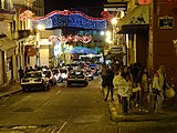
El Callejón del Diamante (Diamond Lane) is probably the most famous alley in the historic center of Xalapa. The alley, no more than 5 meters wide, is like the artist's quarter of the city. It is also a small sales alley, where hawkers sell typical food and handicrafts. There are also numerous small cafés in the alley. At night the alley is completely filled with people of all ages.
Legend has it that the name comes from a young Creole who wore a black diamond on her engagement ring. When she happened to forget this ring with her lover in the alley, the betrayal was exposed. Her future, jealous husband then murdered her in the same alley and so the name stayed with Callejón del Diamante.
Xalapa Cathedral
The Cathedral of Xalapa (official name Catedral Metropolitana de la Immaculada Concepción de Xalapa , Cathedral of the Conception of Mary of Xalapa) was built in 1641. In 1772 it was completely rebuilt. The church was almost completely rebuilt in the baroque style. At that time the new bell was also imported from England . In 1896 the cathedral of Xalapa was rebuilt. Especially the entrance was built in the neo-Gothic style. The cathedral has kept this shape to this day.
Museums
The Museo de Antropología de Xalapa - MAX with a focus on Olmec culture is the second most important at national level after the national museum of Chapultepec . In addition to numerous stone heads, the history of the cultures along the Gulf of Mexico is explained in more detail.
In the Hacienda El Lencero of the former President of Mexico Antonio López de Santa Anna (1794–1876) you can look into life in a former manor house. The hacienda was López's house around 1850. The complex includes parks, several houses, a lake, its own church and a huge old tree. The museum is in close proximity to the small Xalapa airport.
Parks and recreational areas
From Parque Juárez, right next to the government palace and the church, you have a fantastic view over the western part of Xalapa to the Cofre de Perote and the often snow-capped Pico de Orizaba if there is no fog. Craft and art markets are also held in the park. Local bands of all genres can often be found on the stage, especially on weekends in summer.
Xalapa has various large local recreation areas in the city, some of which are state-protected. The Macuiltépetl has been protected as Parque Estatal at state level since 1978 . The recreation area extends around the wooded hill of the extinct volcano on 31 hectares.
Since 1991, the Cerro de la Galaxia in the north of the city has been on the list of protected areas as Zona Sujeta a Conservación Ecológica. This second, large local recreation area on urban land extends over 40 hectares.
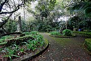
A third, large area is the Parque Estatal Francisco Javier Clavijero in the west of the city. This 62 hectare area was opened in 1975 and is located on the old road to Coatepec . A botanical garden , which has belonged to the state Instituto de Ecología since 1989, has been integrated into the same area . Both institutions are named after the local writer Francisco Javier Clavijero . The grounds of the botanical garden include around 6,000 specimens of 700 plant species, both native and exotic. A special focus is placed on conifers. The garden also has a collection of various cycads from the cloud forests and a Genuino Coatepec coffee plantation .
After all, the Reserva Natural El Tejar with its 133 hectares has also served as an urban green lung since 1986. This is located in the south of the city north of the Arco Sur and west of the Las Animas district. The premises of the Universidad Anáhuac and the Museo Interactivo de Xalapa, which has been closed since the end of 2018, are integrated into the forests .

Others
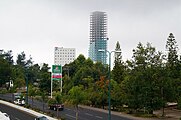
The Torre Animas (Tower of Animas), built in 1993, is located in the south of the city and was the tallest building in the city at 62 meters (18 floors). Its south wall often serves as an advertising space with a view of the main Lázaro Cárdenas traffic axis . Since 2016, the Torre Centro Mayor opposite has been the new tallest building in the city with 30 floors and 134 meters. It serves as an office building.
Due to the hilly topography, there are some high bridge structures in the city of Xalapa and the surrounding area . While the MEX-140 (Veracruz-Perote) toll road bridges serve to cross the valleys and streams in the surrounding area , there are several bridges and similar structures in the city of Xalapa, which relieve the city's intersections. The four-lane Puente Bicentenario Plaza Crystal to the west of the center is particularly spectacular . At 883 meters, it is the longest bridge in the city and has a total of three entrances and exits. The construction cost between 200 and 250 million pesos and opened in early May 2010. Since then it has relieved one of the city's busiest intersections.
Furthermore, a little further south, at the intersection of Lázaro Cárdenas / Araucarias / 20 de Noviembre , there is a roundabout with an underpass. While the city traffic and the four entrances and exits of the MEX-140 flow into the multi-lane roundabout, the transit traffic runs on four lanes under the roundabout. There is a green araucaria sculpture on the top .
In the neighborhood
There are two waterfalls near Xalapa. One, the Texolo waterfall (82 meters high), near Xico and the other, the Naolinco waterfall (90 meters high), are located around 30 minutes outside the city in the surrounding hills.
The main reason for traveling to Xalapa is the area around Jalcomulco, which is known for sports such as rafting, climbing, zip lines, hiking and mountain biking.
photos
Xalapa at night

Square in the center of Xalapa

The Parque Juarez in the center of the city

Panorama of the city seen from the hill

Iglesia de San José in the eastern center of Xalapa

Wall paintings in the Los Sauces district
The Centro Torre Mayor (134 meters) is the tallest building in the city (under construction in 2015)
The Macuiltépetl is one of the city's green lungs

The state court is located on Lázaro Cárdenas in close proximity to Plaza Crystal

The government building of the state of Veracruz in Xalapa

The Cofre de Perote as seen from Xalapa

Xalapa with the Pico de Orizaba as the highest mountain in Mexico
.jpg)


Special
- Various plants bear the city name in their term. The chilli plant Jalapeño from Mexico is named after Xalapa. However, jalapeño is rarely grown commercially in the Xalapa region these days. The miracle flower , in its Latin name Mirabilis Jalapa, is also based on the name of the city of Xalapa. Finally, the drug Tubera Jalapae should also be mentioned. It came to Europe in the 17th century, with the Spanish taking over the use from the Indians.
- In Mexico, Xalapa is famous for the drizzle and fog that always covers the city from the north in autumn, winter and spring evening. The so-called chipi-chipi is due to the collision of the dry, cold mountain air and the moist, warm sea air in the region of Xalapa. It enables plants that need a lot of moisture to grow and is also responsible for numerous car accidents.
Twin cities
International
-
 Ambato , Ecuador (since 1994)
 -
 Omaha , USA (since 2005)
 -
 La Antigua , Guatemala (since 2008)
 -
 Managua , Nicaragua (since 2016)
 -
 Zouan-Hounien , Ivory Coast (since 2017)
 -
Covina , USA
-
Laredo , USA
-
Mobile , USA
-
Columbia , USA
-
 Paraná (Entre Ríos) , Argentina
-
 Curitiba , Brazil
Inside Mexico
-
 Cotija de la Paz , Michoacán (since 2007)
-
Toluca , Estado de México (since 2011)
-
Zacatecas , Zacatecas (since 2016)
-
Torreón , Coahuila
-
Puebla , Puebla
-
Santiago de Querétaro , Querétaro
-
Victoria de Durango , Durango
-
Matamoros , Tamaulipas
-
Cancun , Quintana Roo
-
Chilpancingo , Guerrero
-
Veracruz , Veracruz
-
Perote , Veracruz
-
Acayucan , Veracruz
Personalities
- Manuel Arzú (1775–1835), head of state of Nicaragua
- José Joaquín de Herrera (1792–1854), General and 14th President of Mexico
- Antonio López de Santa Anna (1794–1876), general and eleven times (!) Head of State of Mexico, especially known for the huge cedings of territory from Mexico to the USA (see Treaty of Guadalupe Hidalgo and Gadsden purchase )
- José Antonio Mexía (1800–1839), politician, military man and businessman
- Sebastián Lerdo de Tejada (1823–1889), 27th President of Mexico
- Rafael Montes de Oca (* around 1832, † 1885 or later), ornithologist and painter
- Miguel Covarrubias Acosta (1856–1924), Ambassador and Foreign Minister
- Enrique Conrado Rébsamen (1857–1904), pioneer in the Mexican school system with Swiss roots
- Eduardo Hernández Moncada (1899–1995), composer, pianist and conductor
- Óscar Brauer Herrera (* 1922), agricultural scientist and politician
- Sergio Obeso Rivera (1931–2019), clergyman, cardinal of the Roman Catholic Church and Archbishop of Jalapa
- Rafael Ortega El Xalapa (* approx. 1957), football player
- Gabriel Orozco (* 1962), concept artist
- Javier Camarena (* 1976), tenor
- Bárbara Bonola (* 1987), triathlete
- Julio Nava (* 1989), football player
- Nazari Urbina (* 1989), tennis player
Individual evidence
- ↑ a b [1]
- ↑ a b c d e INEGI: Anuario estadístico de Veracruz. Retrieved March 11, 2019 .
- ↑ a b c d e f g h CEIEG Veracruz: Cuadernillos Municipales Xalapa. Retrieved March 11, 2019 .
- ↑ World Maps of Köppen-Geiger climate classification. Retrieved March 12, 2019 .
- ↑ Climatological data from the Xalapa weather station (Las Animas): SERVICIO METEOROLÓGICO NACIONAL ( Memento from February 21, 2013 in the web archive archive.today )
- ↑ Climatological data of the weather station Xalapa (Briones): SERVICIO METEOROLÓGICO NACIONAL ( Memento from February 21, 2013 in the web archive archive.today )
- ^ Servicio Meteorológico Nacional: Climatologia Perote. Retrieved March 14, 2019 .
- ^ A b Servicio Meteorológico Nacional: Climatologia Xalapa-Las Anmias. Retrieved March 14, 2019 .
- ^ Servicio Meteorológico Nacional: Proyecto bases de datos climatológicos: Xalapa-DGE. Retrieved March 14, 2019 .
- ^ A b Servicio Meteorológico Nacional: Proyecto bases de datos climatologicos: Xalapa-Las Animas. Retrieved March 14, 2019 .
- ↑ Hurricane Fifi, 1974 ( Memento of December 3, 2008 in the Internet Archive )
- ↑ a b Datos Generales. Retrieved March 27, 2019 .
- ↑ a b c d e f g h i j k l m n o p q r s t u v w x y z aa ab Veracruz - Xalapa. Retrieved March 12, 2019 .
- ↑ a b c d e f Enciclopedia de los Municipios y Delegaciones de México: Xalapa, section Cronología de Hechos (Spanish)
- ↑ a b TodoXalapa - Historia. June 6, 2009, accessed March 12, 2019 .
- ↑ Duckach: Tu Xalapa: La Catedral (La iglesia de una sola torre). In: Tu Xalapa. October 29, 2007, accessed March 12, 2019 .
- ↑ Un día como hoy José María Alfaro elevó el primer globo aerostático en América. May 18, 2016, accessed March 12, 2019 .
- ↑ Roberto Peredo: Leño, Diego. Retrieved March 12, 2019 .
- ^ Irving W. Levinson: Wars within War. Mexican Guerrillas, Domestic Elites, and the United States of America . Fort Worth 2005, pp. 19 .
- ↑ Paulo César López Romero: Un Historiador y sus viajes: Los Sauces y el Ferrocarril. Una historia casi en el olvido ... In: Un Historiador y sus viajes. May 1, 2016, accessed March 12, 2019 .
- ^ Bahn ( Memento of May 13, 2012 in the Internet Archive ) in the Mexico Lexicon , accessed on February 6, 2009
- ↑ Servicio Nacional Sismologico: Sismos Históricos Sismo de 1920 en Xalapa, Veracruz. Retrieved March 12, 2019 .
- ^ Plaza Crystal - Xalapa. Retrieved March 12, 2019 .
- ↑ a b c SEDESOL: Unidad Microregiones: Información de localidad: Xalapa-Enríquez. Retrieved March 27, 2019 .
- ↑ Population pyramid - The graphic representation of the age structure. Retrieved March 11, 2019 .
- ^ México en Cifras. January 1, 2016, accessed March 27, 2019 (Spanish).
- ^ México en Cifras. January 1, 2016, accessed March 27, 2019 (Spanish).
- ^ México en Cifras. January 1, 2016, accessed March 27, 2019 (Spanish).
- ^ México en Cifras. January 1, 2016, accessed March 27, 2019 (Spanish).
- ^ México en Cifras. January 1, 2016, accessed March 27, 2019 (Spanish).
- ^ México en Cifras. January 1, 2016, accessed March 27, 2019 (Spanish).
- ↑ Población por Localidad 2000. January 1, 2016, accessed on March 27, 2019 (Spanish).
- ^ México en Cifras. January 1, 2016, accessed March 27, 2019 (Spanish).
- ^ México en Cifras. January 1, 2016, accessed March 27, 2019 (Spanish).
- ↑ Xalapa | Mexico. Retrieved March 12, 2019 .
- ↑ Chedraui - Historia. Retrieved March 12, 2019 .
- ↑ VERACRUZ | Corredor del Altiplano: Libramiento de Xalapa - Page 16 - SkyscraperCity. Retrieved March 11, 2019 .
- ^ Secretaría de Comunicaciones y Transportes de México ( Memento of July 19, 2006 in the Internet Archive ), accessed on February 6, 2009
- ↑ Skyscrapercity-Forum , discussion about the construction of the MEX-140, accessed on February 6, 2009
- ↑ alcalorpolitico.com: El Puente Chiltoyac, el más alto de todo el estado: forma parte del Corredor del Altiplano: SCT. Retrieved August 4, 2019 (Spanish).
- ↑ Xalapa Bridge - HighestBridges.com. Retrieved August 4, 2019 .
- ↑ PUENTE DE DOBLE VOLADIZO “EL CIMARRON”. Retrieved August 4, 2019 .
- ↑ Aerolíneas no quieren operar en aeropuerto de El Lencero. December 27, 2017. Retrieved March 11, 2019 (mexican Spanish).
- ^ A b Secretaría de Educación de Veracruz »Consulta. Retrieved March 11, 2019 (Spanish).
- ↑ Universidades en Xalapa * Guía 2019. In: Mextudia. Retrieved March 11, 2019 (mexican Spanish).
- ↑ Historia - Orquesta Sinfónica de Xalapa. November 21, 2010, accessed March 11, 2019 .
- ↑ DEMOS, Desarrollo de Medios, SA de CV: La Jornada: La Orquesta Sinfónica de Xalapa regresa a la Sala Nezahualcóyotl. November 29, 2012, Retrieved March 11, 2019 (mexican Spanish).
- ↑ Velódromo de Xalapa. In: Xalapa Veracruz. June 9, 2016, accessed March 11, 2019 (Spanish).
- ↑ | XEU Deportes - Los líderes en deportes. Retrieved March 11, 2019 .
- ^ Halcones UV Football. Retrieved March 11, 2019 .
- ↑ Enciclopedia de los Municipios y Delegaciones de México: Xalapa, section Leyendas (Spanish)
- ↑ TravelByMexico
- ↑ Xalapa.net , accessed 7 February 2009
- ↑ Lonelyplanet entry about Juarez Park , accessed on February 7, 2009
- ↑ Grupo JV I centro mayor xalapa micrositio. Retrieved March 11, 2019 .
- ↑ Costará 250 millones el Puente de Plaza Crystal y los terminarán hasta March 2010. In: Agenda Veracruz. com. October 15, 2009, Retrieved March 11, 2019 (European Spanish).
- ↑ Supervisando los avances en la construcción del Puente Plaza Cristal, en la ciudad de Xalapa, Ver. | Facebook. Retrieved March 11, 2019 .
- ↑ a b VERACRUZ. Retrieved March 13, 2019 .
- ↑ a b c d e f g h i j k l m n o p q Hermanamientos de oropel - Quadratín. In: Quadratín Veracruz. October 6, 2014, accessed March 13, 2019 (Spanish).
- ↑ Firman convenio de Xalapa hermanamiento y Antigua. June 28, 2012, accessed March 13, 2019 .
- ↑ Los alcaldes de Xalapa, Veracruz, y de Managua Nicaragua, formalizan el hermanamiento entre las dos ciudades… In: Textos Politicos, lo que piensan, dicen y hacen los protagonistas de la vida pública de Veracruz, México y el Mundo. February 2, 2016, Retrieved March 13, 2019 (mexican Spanish).
- ↑ Aprueba Xalapa hermanamiento con la ciudad de Costa de Marfil - Imagen del Golfo - Agencia Imagen del Golfo. Retrieved March 13, 2019 .
- ↑ Se hermana Xalapa con Cotija de la Paz. June 28, 2012, accessed on March 13, 2019 .
- ↑ El Universal: Firman Duarte y Peña Nieto alianza Xalapa-Toluca. September 6, 2011, accessed October 24, 2011 .
- ↑ La Jornada Veracruz | Fortalece Xalapa el hermanamiento con Zacatecas, dice Américo Zúñiga. Retrieved March 13, 2019 .
Web links
- City Council website (Spanish)
- Xalapa Anthropological Museum (Spanish)