
Avilés
| Avilés municipality | |||
|---|---|---|---|
 Avilés Town Hall
|
|||
| coat of arms | Map of Spain | ||

|
|
||
| Basic data | |||
| Autonomous Community : |
|
||
| Comarca : | Avilés | ||
| Coordinates | 43 ° 33 ′ N , 5 ° 56 ′ W | ||
| Height : | -139 msnm | ||
| Area : | 27 km² | ||
| Residents : | 78,182 (Jan 1, 2019) | ||
| Population density : | 2,895.63 inhabitants / km² | ||
| Postal code : | 33400 -33403 | ||
| Municipality number ( INE ): | 33004 | ||
| Nearest airport : | Asturias Airport 15.4 km | ||
| administration | |||
| Mayoress : | Mariví Monteserín ( PSOE ) (since 2015) | ||
| Address of the municipal administration: | Plaza de España 1, 33402 Avilés | ||
| Website : | ayto-aviles.es | ||
| Location of the municipality | |||

|
|||

Avilés [ aβiˈles ] is the third largest city in Asturias .
At the mouth of the Alvares , the estuary of Avilés (Ría de Avilés), west of the Cape Rock, there is an important seaport and an industrial area. There are several well-known beaches in the city.
geography
The municipality of Avilés is divided into six parroquias :
|
Neighboring municipalities of Avilés are La Carriona, Llaranes, Miranda, San Cristóbal and Villalegre.
climate
Avilés has an Atlantic climate. In summer there is a lot of sun, but also a lot of rain, while the winters are rather cold. During winter there can be occasional snowfall on the coasts. Compared to most other Spanish regions, Asturias has a lot of rainfall. The bathing season on the Cantabrian Sea usually ends at the end of September / beginning of October, depending on the weather, with the beach staff (lifeguards, rescue and security services) usually only on duty until mid-September.
history
The discovery of two axes is the only evidence that there was already a human population here in prehistoric times. The name of the city goes back to the name of a Roman professor: Abilius . The oldest, best-known document is a tender for two churches from the Asturian King Alfonso III. from the year 905. In the Middle Ages, this was one of the most important ports in the Bay of Biscay , which was mainly used for trade with France. During this time there were two parts of the city: a fishing district called Sabugo and an aristocratic center called La Villa . The districts were separated from each other by a river. Part of the river mouth was straightened in the 19th century to enable the two parts of the city to be connected. After that, the city expanded beyond the city wall, which has since been torn down. In the 20th century, the city grew very quickly due to the settlement of heavy industry in the region. Nowadays people are trying to establish new industries here, as Asturias as a mining region no longer has a future and alternative jobs have to be created.
Population development

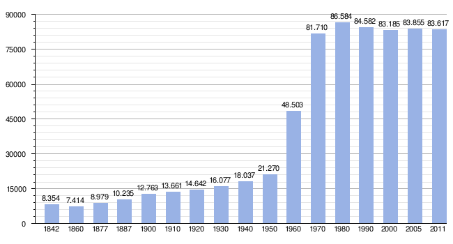
|
| Source: Instituto Nacional de Estadística de España - graphic processing for Wikipedia |
architecture

Sights include the churches of Santo Tomás de Canterbury and San Nicolás de Bari (both from the 13th century). The names indicate the influence of trade in the Middle Ages. The grave chapel of Los Alas dates from the 14th century .
Civil monuments are the baroque palace Camposagrado and the Oscar Niemeyer cultural center, which opened in 2011 .


Regular events
- Inter-Celtic Festival: The Inter-Celtic Festival is the city's largest cultural event. It is a concert of Celtic music that is attended not only by locals, but also by British and Irish people.
- Antroxu: Carnival event
- Bollu Festival : Bollu is a traditional pastry from the region
- St. Agustin Festival:
politics
After the elections since 1979, the 25 seats of the municipal council have been distributed as follows:
| Distribution of seats in the Aviles parish council | ||||||||||
|---|---|---|---|---|---|---|---|---|---|---|
| Political party | 1979 | 1983 | 1987 | 1991 | 1995 | 1999 | 2003 | 2007 | 2011 | 2015 |
| PSOE | 10 | 17th | 10 | 12 | 9 | 12 | 10 | 11 | 10 | 8th |
| PP | 6th | 5 | 7th | 11 | 8th | 10 | 8th | 6th | 6th | |
| IU | 4th | 2 | 4th | 5 | 5 | 4th | 4th | 2 | 3 | 3 |
| UCD / CDS | 11 | 6th | 1 | |||||||
| URAS / URAS- PAS | 1 | |||||||||
| ASIA | 1 | 4th | ||||||||
| FAC | 6th | |||||||||
| Somos Aviles | 5 | |||||||||
| C's | 2 | |||||||||
| Ganemos | 1 | |||||||||
| Total | 25th | 25th | 25th | 25th | 25th | 25th | 25th | 25th | 25th | 25th |
economy
| Employees | proportion of | ||||
|---|---|---|---|---|---|
| TOTAL | 29,583 | 100% | |||
| Agriculture, livestock and fishing | 413 | 1.40% | |||
| Industry | 5,787 | 19.56% | |||
| Construction industry | 3,479 | 11.76% | |||
| Service companies | 19,904 | 67.28% | |||
| Data from the Statistical Office for Economic Development in Asturias, status 2009 (PDF; 115 kB), SADEI | |||||
Town twinning
- St. Augustine (Florida, USA)
- Saint-Nazaire (Pays de la Loire, France)
- Cárdenas (Cuba)
- El Aaiún (Western Sahara)
sons and daughters of the town
- Pedro Menéndez de Avilés (1519–1574), first governor of Florida in the 16th century
- Juan Carreño de Miranda (1614–1685), painter
- Julián Orbón (1925–1991), Cuban composer
- Jorge Guerricaechevarría (born 1964), screenwriter
- Alfonso Menéndez (* 1966), archer
- Rubén Garabaya (* 1978), handball player
- Yago Lamela (* 1977), long jumper
- Sergio Fernández González (born 1977), football player
- Esteban Suárez (* 1975), football player
- David Álvarez Aguirre (* 1984), Equatorial Guinean football player
- Sergio Aido (* 1988), poker player
- Sergio Álvarez (* 1992), football player

Palacio Camposagrado
Palacio Llano Ponte

Chapel and source Rivero

Palacio de Balsera

Ría de Avilés


Web links
- Tourist information (English)
- Information about Avilés. Official website for tourism in Spain (German)
- Images of Aviles ( Memento from July 22, 2012 in the Internet Archive )
- Population numbers. INE
Individual evidence
- ↑ Cifras oficiales de población resultantes de la revisión del Padrón municipal a 1 de enero . Population statistics from the Instituto Nacional de Estadística (population update).
- ↑ 2011 Spanish Ministry of the Interior
- ↑ Asturias - Avilés ( Memento of June 8, 2015 in the web archive archive.today )

Allande | All | Amieva | Avilés | Belmonte de Miranda | Bimenes | Boal | Cabrales | Cabranes | Candamo | Cangas del Narcea | Cangas de Onís | Caravia | Carreño | Caso | Castrillón | Castropol | Coaña | Colunga | Corvera | Cudillero | Degaña | El Franco | Gijón | Gozón | Grado | Grandas de Salime | Ibias | Illano | Illas | Langreo | Laviana | Lena | Llanera | Llanes | Mieres | Morcín | Muros de Nalón | Nava | Navia | Noreña | Onís | Oviedo | Parres | Peñamellera Alta | Peñamellera Baja | Pesoz | Piloña | Ponga | Pravia | Proaza | Quirós | Las Regueras | Ribadedeva | Ribadesella | Ribera de Arriba | Riosa | Salas | San Martín de Oscos | San Martín del Rey Aurelio | San Tirso de Abres | Santa Eulalia de Oscos | Santo Adriano | Sariego | Siero | Sobrescobio | Somiedo | Soto del Barco | Tapia de Casariego | Taramundi | Teverga | Tineo | Valdés | Vegadeo | Villanueva de Oscos | Villaviciosa | Villayón | Yernes y Tameza
Avilés | Candamo | Castrillón | Corvera | Cudillero | Gozón | Illas | Muros de Nalón | Pravia | Soto del Barco