
Osterburken
| coat of arms | Germany map | |
|---|---|---|

|
Coordinates: 49 ° 26 ' N , 9 ° 26' E |
|
| Basic data | ||
| State : | Baden-Württemberg | |
| Administrative region : | Karlsruhe | |
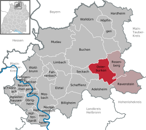
| County : | Neckar-Odenwald district | |
| Height : | 247 m above sea level NHN | |
| Area : | 47.32 km 2 | |
| Residents: | 6507 (Dec 31, 2018) | |
| Population density : | 138 inhabitants per km 2 | |
| Postal code : | 74706 | |
| Primaries : | 06291, 06292, 06295 | |
| License plate : | MOS, BCH | |
| Community key : | 08 2 25 075 | |
| LOCODE : | DE EAST | |
| City structure: | 4 districts | |
City administration address : |
Marktplatz 3 74706 Osterburken |
|
| Website : | ||
| Mayor : | Jürgen Galm ( CDU ) | |
| Location of the city of Osterburken in the Neckar-Odenwald district | ||
  |
||

Osterburken is a town in the Neckar-Odenwald district in Baden-Württemberg . It belongs to the European metropolitan region of Rhine-Neckar (until May 20, 2003 the Lower Neckar region and until December 31, 2005 the Rhine-Neckar-Odenwald region ). Because of its location on the Upper Germanic-Rhaetian Limes and the related numerous archaeological finds from Roman times , it is also known as a Roman city . It is crossed by the Kirnau River.
geography
The district lies on the Kirnau in the building land between the Odenwald and the Jagsttal at a height between 240 m to 392 m above sea level. NN .
City structure
The former communities of Bofsheim, Hemsbach and Schlierstadt belong to the city of Osterburken . Only the villages of the same name belong to the former communities of Bofsheim and Hemsbach. The town of Osterburken within the boundaries of 1970 includes the town of Osterburken, the settlement "Neue Heimat" and the homestead Marienhöhe (formerly Haide). The village of Schlierstadt and the Seligental homestead (Selgental) belong to the former municipality of Schlierstadt .
In the area of the former municipality of Hemsbach, there is the uncertainly localized Vustenhemsbach desert , in the city of Osterburken in the territorial status of 1970 there are the deserted areas of Gieß and Hügelsdorf or Huchelsdorf and in the area of the former municipality of Schlierstadt is the Heristatt desert.
history
Until the 19th century
The first archaeological evidence of a settlement in the area of today's city comes from the Neolithic around 4000 BC. The Romans established a fort on the outer Upper Germanic Limes around 160 AD . After the " Limesfall " around 260 AD, continuous settlement by the Alemanni is assumed. The oldest surviving written mention of Osterburken as "Burchaim" in the Wingarteiba district can be found in the confirmation from the year 822 for a deed of donation with which a St. Martin's basilica was given to the diocese of Würzburg by Karlmann around 80 years earlier . The name Augusta Nova, a civitas mentioned by the geographer of Ravenna , was suspected to be Osterburken, but it is not certain.
During the time of the tribal duchies , the place was in the Duchy of Franconia .
Cistercian women founded the Seligental monastery in 1236 . After the death of the last count of the Rieneck- Rothenfels line in 1333, his nephew, Ulrich II von Hanau , inherited , among other things, “Burgheim” (Osterburken). On January 9, 1356 - the same day on which the Golden Bull was confirmed - Emperor Charles IV granted market rights for Osterburken at the Reichstag in Nuremberg. Ulrich IV. Von Hanau sold the Osterburken, located far from his heartland, in 1376 to Archbishop Ludwig von Mainz. Osterburken was besieged in vain in 1463 as part of the Mainz collegiate feud . Since the 16th century the place was called Osterburken (the eastern Burken) to distinguish it from Neckarburken (Burken am Neckar). In the Markgräflerkrieg of 1552 the Cistercian convent was devastated. Towards the end of the Thirty Years War , Osterburken also became a theater of war and the plague broke out.
As part of the Reichsdeputation Hauptschluss , Osterburken became part and official seat of the Principality of Leiningen . After its dissolution by the Rhine Confederation Act three years later, the city fell to the Grand Duchy of Baden . Initially, Osterburken was the seat of an office there , but it was moved to Adelsheim in 1828 . From then on, Osterburken was part of the Adelsheim office . During the March Revolution of 1848 there was revolutionary unrest in Osterburken with the plunder of the Princely-Leiningschen Hofgut Marienhöhe.
In 1866, Osterburken was connected to the Mannheim-Würzburg railway line and in 1868 to Stuttgart-Würzburg.
20th century
In 1909 the place got a public water supply and in 1923 an electricity network.
At the end of March 1945 an “evacuation” train carrying concentration camp prisoners from Neckarelz concentration camp was parked in front of the site for three days. Nine people who were buried in a collective grave in the current old cemetery died, a memorial stone is there.
Incorporations
-
 January 1, 1971: Hemsbach
 -
 January 1, 1974: Bofsheim
 -
 January 1, 1975: Schlierstadt
Religions
In Osterburken there are three Roman Catholic (Osterburken and Schlierstadt) and two Protestant (Osterburken and Bofsheim) communities. The district of Hemsbach belongs to the Catholic parish of Adelsheim.
politics
Municipal council
The parish council normally has 16 honorary members who are elected for five years. This number can increase with compensation seats. In addition, the mayor acts as the municipal council chairman with voting rights.
The Unechte Teilorteschahl guarantees the districts a fixed number of seats: at least twelve councils from the main town of Osterburken, at least two councils from Schlierstadt, and at least one council from Bofsheim and Hemsbach.
The 2019 local elections led to the following result (in brackets: difference to 2014):
| Municipal Council 2019 | ||||
|---|---|---|---|---|
| Party / list | Share of votes | Seats | ||
| FWV | 46.8% (+6.8) | 8 (+1) | ||
| CDU | 32.4% (−7.2) | 5 (−1) | ||
| SPD | 20.8% (+0.4) | 3 (± 0) | ||
| Turnout: 51.6% (+7.9) | ||||
mayor
In December 2005 Jürgen Galm was elected as the new mayor. In December 2013 he was confirmed for a second term with 97.96% of the vote.
coat of arms
Blazon : "In silver a six-spoke red wheel."
Town twinning
Osterburken has a partnership with the municipality of Hondschoote in northern France.
Culture and sights

Cultural monuments
Fort and Roman Museum

In Osterburken is the archaeological excavation zone around the former Roman fort Osterburken that is part of the 2005 World Heritage Site collected Upper German-Rhaetian Limes is. The cohort fort, along with the annex fort, bathing buildings and consecration area, is one of the richest Roman provincial sites in southwest Germany.
The fort bath was integrated into a museum after its exposure. There is also a copy of the most important archaeological find from Osterburken, a Mithras relief depicting the mythological killing of the primal animal by the god Mithras. The original is now in the possession of the Badisches Landesmuseum Karlsruhe.
The Römermuseum Osterburken was reopened as a supra-regional Limes information center after renovation and expansion in 2006. It is a branch museum of the Archaeological State Museum Baden-Württemberg .


South of Osterburken, at the location of the former WP 08/32 Förstlein watchtower, there is a 1: 1 replica that can be viewed and climbed as a viewing tower .
Histotainment Park Adventon at Marienhöhe
The Adventon Histotainment Park has been under construction on the former Marienhöhe estate of the Prince of Leiningen since 2004 . A historical park is being built here on over 40 hectares with the means of experimental archeology.
theatre
The Badische Landesbühne gives regular guest performances in the building site.
Buildings
The Catholic Kilian's Church is located in the center of Osterburken . The free-standing historic bell tower is from a previous building, the church building was rebuilt from 1970 to 1974 as a multi-segmented concrete structure with numerous relief sculptures by Emil Wachter . Not far from the church, the historic city tower with a base from the 15th century is another landmark of the place. Other historical buildings in Osterburken are the octagonal Kilian's Chapel , which was built in 1748 on the site of the then poor cemetery, next to it the city fountain from 1601, which was moved from the Brunnenviertel in 1956 for the 600th anniversary of the city, and not far from it is the city mill, which has been attested since the Middle Ages . The former Cistercian monastery “Seligental” (1236–1568) is located in the Schlierstadt district. The monastery complex is only partially preserved on the farm that is used today for agriculture. Some tombstones of abbesses and nuns can be found on the outside of the St. Gangolf church in Schlierstadt.
The Mauritius Church in the district of Hemsbach, which was first mentioned in documents in 1281 and was a destination for pilgrimages until the 19th century, is one of the most important buildings in the entire municipality of Osterburken .
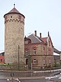
City tower

Kilian's Chapel

Kirnau Bridge with a view of the city center


Sports
In the 1977/78 season, SV Osterburken won the championship in the Odenwald regional football league .
Economy and Infrastructure

traffic
Public transport
Osterburken is a railway junction: the Frankenbahn Stuttgart – Würzburg and the Neckarelz – Osterburken railway , part of the Badische Odenwaldbahn , meet here. On the latter route, the city is the end of the line S1 of the RheinNeckar S-Bahn . Regional Express trains run to Würzburg every two hours, which are supplemented by a few additional trains. Regional trains with all stops on the way to Lauda only run occasionally. Regional express trains run to Stuttgart every 60/120 minutes. Regional trains run every hour to Heilbronn, sometimes further to Ulm .
Private transport
Osterburken can be easily reached via the motorway junction of the same name on the A 81 Stuttgart – Heilbronn – Würzburg (4 km, district of Ravenstein). In addition, the B 292 Bad Schönborn - Mosbach - Adelsheim - Königshofen passes the village.
Biking and hiking trails
The German Limes Cycle Route runs through the city . It leads from Bad Hönningen through Westerwald , Taunus and Odenwald to Regensburg, 818 kilometers away, and is based on the historical course of the Upper German-Raetian Limes . Furthermore, Osterburken is the start and end point of the long-distance cycle route Kurpfalzachse to Lambrecht (Palatinate) . This cycle path runs for around 220 km in an east-west direction through the Rhine-Neckar metropolitan region.
As part of the German Limes hiking trail , the Limes hiking trail run by the Swabian Alb Association runs through Osterburken. From Miltenberg to Osterburken, this path is looked after as the Eastern Limes Path by the Odenwald Club.
The city of Osterburken is part of the sculpture cycle path .
Established businesses
The most important employer is AZO GmbH + Co. KG , a machine factory for the food, pharmaceutical, chemical and plastics industries. The People's Bank Kirnau and the Sparkasse Neckartal-Odenwald have a head office in Ostburken each.
In addition, other companies have settled in the "Regional Industrial Park Osterburken" not far from the A 81. These include the fruit juice manufacturer Erwin Dietz GmbH (brand: Dietz Fruchtsafts ) and Claas Württemberg GmbH, a dealer of agricultural tractors and machines.
The sports and adventure center for skydiving and diving Southsidebase GmbH is located in the Schlierstadt district on one of the oldest jumping sites in Germany.
Educational institutions
In Osterburken there is a grammar school sponsored by the Neckar-Odenwald district , a secondary school and a primary and community school (Schule am Limes). All have been developed as all-day schools . In addition, the Astrid Lindgren School is a special education and advice center with a focus on learning. There are also three Roman Catholic and two Protestant kindergartens.
Personalities
Honorary citizen
- Sister Amalberga (nurse), died February 11, 2013
- Adolf Zimmermann (entrepreneur), died March 15, 2013
- Klemens Brümmer (Mayor 1963–1991), died March 20, 2007
- Ernst Robert Ellwanger (building contractor), died February 15, 1982
sons and daughters of the town
- Georg Zingel (1428–1508), born in the Schlierstadt district, Catholic theologian
- Johann Nepomuk Schäfer (1751–1796), Roman Catholic clergyman, theologian and university professor
- Wilhelm Eichhorn (1846–1923), born in Bofsheim, Evangelical Lutheran pastor, rector of the Neuendettelsau Diakonie
- August Becker (1879–1953), physicist and university professor
- Leopold Nenninger (1880–1970), organ builder
- Harald S. Müller (* 1951), civil engineer
- Uli Mayer-Johanssen (* 1958), designer
- Gerd Häfner (* 1960), Roman Catholic theologian
- Margaret Horb (* 1967), politician (CDU), Member of the Bundestag
literature
- Helmut Maisch and Herbert Walz: Osterburken ... as it used to be . Geiger, Horb am Neckar 1998. ISBN 3-89570-503-9
- Walter Koupil: Seligental, Schlierstadt building land. Chronicle of a Forgotten Monastery . 1990.
- Helmut Neumaier: Osterburken Stations in its history . Milte, Heidelberg 1973.
- Britta Rabold, Egon Schallmayer, Andreas Thiel (eds.): The Limes. The German Limes Road from the Rhine to the Danube . Theiss, Stuttgart 2000. ISBN 3-8062-1461-1
- Egon Schallmayer : The Limes. Story of a border. CH Beck, Munich 2006. ISBN 3-406-48018-7 ( Knappe, current introduction. )
- Elmar Weiss: The Seligental Monastery near Osterburken . Publication of the historical building land association. 1986.
- Elmar Weiss, Helmut Neumaier: History of the city of Osterburken . City of Osterburken, Osterburken 1986.
Web links
- Official website of Osterburken
- LEO-BW, discover regional studies online in Osterburken
- Osterburken Roman Museum
- Rinschbachtal , website of the Hemsbach district
Individual evidence
- ↑ State Statistical Office Baden-Württemberg - Population by nationality and gender on December 31, 2018 (CSV file) ( help on this ).
- ^ The state of Baden-Württemberg. Official description by district and municipality. Volume V: Karlsruhe District Kohlhammer, Stuttgart 1976, ISBN 3-17-002542-2 . Pp. 310-313.
- ^ Text and translation of the document of Emperor Ludwig the Pious from 822
- ^ Johannes Gebert: Osterburken in the Baden Franconia . City of Osterburken, 1956. p. 63.
- ↑ Josef Durm; Franz Xaver Kraus: "The Art Monuments of the Grand Duchy of Baden", 1901, p. 179.
- ↑ Memorial sites for the victims of National Socialism. A documentation, Volume I, Bonn 1995, p. 68, ISBN 3-89331-208-0 .
- ^ Federal Statistical Office (ed.): Historical municipality directory for the Federal Republic of Germany. Name, border and key number changes in municipalities, counties and administrative districts from May 27, 1970 to December 31, 1982 . W. Kohlhammer, Stuttgart / Mainz 1983, ISBN 3-17-003263-1 , p. 474 .
- ↑ a b Federal Statistical Office (ed.): Historical municipality register for the Federal Republic of Germany. Name, border and key number changes in municipalities, counties and administrative districts from May 27, 1970 to December 31, 1982 . W. Kohlhammer, Stuttgart / Mainz 1983, ISBN 3-17-003263-1 , p. 485 .
- ↑ State Statistical Office Baden-Württemberg: Municipal elections 2019, City of Osterburken ; City of Osterburken: City council election 2019 (PDF) ; accessed June 29, 2019.
- ↑ https://www.rnz.de/nachrichten/buchen_artikel,-Buchen-Osterburken-Galm-mit-98-Prozent-wieder-zum-Buergermeister-gewaehlt-_arid,18233.html
- ↑ Limes replica Förstlein on the website of the Römermuseum Osterburken.
- ^ Fandom: Landesliga Odenwald . Online at daffs.fandom.com. Retrieved July 21, 2019.

Adelsheim | Aglasterhausen | Cheap home | Binau | Book | Elztal | Fahrbach | Hardheim | Hassmersheim | Höpfingen | Hüffenhardt | Limbach | Mosbach | Mudau | Neckargerach | Neckarzimmern | Neunkirchen | Obrigheim | Osterburken | Ravenstein | Rosenberg | Schefflenz | Schwarzach | Seckach | Waldbrunn | Walldürn | Zwingenberg