
Gorkha (District)
| गोर्खा जिल्ला Gorkha district
|
|
|---|---|
 Location of the Gorkha district (red) in Nepal |
|
| Basic data | |
| Country | Nepal |
| province | Gandaki |
| Seat | Gorkha |
| surface | 3610 km² |
| Residents | 271,061 (2011 census) |
| density | 75 inhabitants per km² |
| ISO 3166-2 | NP-P4 |
 |
|
Coordinates: 28 ° 17 ' N , 84 ° 41' E
The Gorkha District ( Nepali गोर्खा जिल्ला ) is one of the 77 districts in Nepal .
Its main town is Gorkha in the Gandaki administrative zone . It is the area of the former principality of Gorkha, which also gave its name to the famous Gurkha soldiers . In the district there is the the earthquake in 2015 destroyed Manakamana Temple. The epicenter of the earthquake was 18 km north-northeast of the city of Gorkha near Barpak .
geography
The 3610 km² district is located in the Central Himalayas directly on the Chinese border in the center of Nepal. Its neighboring districts are: Lamjung , Manang , Tanahu , Dhading and Chitwan . Four major rivers run in and along the district: Chepe , Daraudi , Marsyangdi, and Budhigandaki . The large Annapurna Conservation Area is located in the northern mountainous regions of the district . The highest peak in the Gorkha district is Manaslu at 8163 m , which makes it the eighth highest mountain on earth . Other high mountains in Gorkha are the Himal Chuli ( 7893 m ) and the Ngadi Chuli ( 7871 m ).
history
The district corresponds more or less to the old Principality of Gorkha, from which the unification of Nepal started in the 18th century and after which the Kingdom of Gorkha was named. The place Gorkha was home to the Shah dynasty ; her palace still towers high above the city. King Prithvi Narayan Shah conquered the Kathmandu Valley in 1768 and ascended the throne of the new kingdom. It was only renamed Nepal in the 1930s. The city of Ghorka is a popular tourist destination.
population
According to the census, the district had 271,000 inhabitants in 2011 and a population density of 75 people / km². The largest ethnic group in this district are the Gurkha , but Gurung and Tamang also live in Gorkha.
Administrative division
Cities ( municipalities ) in Gorkha district:
Village Development Committees (VDCs) in Gorkha District:
- Aaru Arbang
- Aaru Chanuate
- Aarupokhari
- Asrang
- Baguwa
- Bakrang
- Barpak
- Bhumlichok
- Bihi
- Borlang
- Bunkot
- Chhaikampar
- Chhoprak
- Chumchet
- Performance
- Deurali
- Dhawa
- Dhuwakot
- Fujel
- Gakhu
- Ghairung
- Ghyachok
- Ghyalchok
- Gumda
- Hansapur
- Harmi
- Jaubari
- Kashigaun
- Kerabari
- Kerauja
- Kharibot
- Khoplang
- Laprak
- Lapu
- Lho
- Makaising
- Manakamana
- Manbu
- Masel
- Mirkot
- Muchhok
- Namjung
- Panchkhuwadeurali
- Pandrung
- Proc
- Samagaun
- Saurpani
- Shrinathkot
- Simjung
- Sirdibas
- Swara
- Rigging
- Takukot
- Takumajhalakuribot
- Tussle
- Tanglichok
- Taple
- Thalajung
- Thumi
- Uiya
photos

Royal Palace in Gorkha

Chipleti village
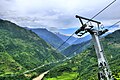
The cable car to Manakamana Temple

The Manakamana Temple

Manaslu, the highest peak in the Gorkha district


_to_Manakamana_Temple_(Nepal).jpg)

.jpg)
See also
Web links
References
- ↑ Central Bureau of Statistics, Census 2011: National Report (pp. 51–52, Population Total and Area in Sq. Km ). ( Memento from May 25, 2013 in the Internet Archive ) (PDF file; 7.5 MB)
- Census Nepal (2001) - at statoids.com (English). Retrieved April 28, 2011.
- Gorkha ( Memento of November 13, 2012 in the Internet Archive ) - at nepalhomepage.com (English). Retrieved April 28, 2011.
Achham | Arghakhanchi | Baglung | Baitadi | Bajhang | Bajura | Bank | Bara | Bardiya | Bhaktapur | Bhojpur | Chitwan | Dadeldhura | Dailekh | Dang Deukhuri | Darchula | Dhading | Dhankuta | Dhanusha | Dolakha | Dolpa | Doti | Gorkha | Gulmi | Humla | Ilam | Jajarkot | Jhapa | Jumla | Kabhrepalanchok | Kailali | Calicot | Kanchanpur | Kapilbastu | Kaski | Kathmandu | Khotang | Lalitpur | Lamjung | Mahottari | Makwanpur | Manang | Morang | Mugu | Mustang | Myagdi | Nawalparasi (Bardaghat Susta East) | Nawalparasi (Bardaghat Susta West) | Nuwakot | Okhaldhunga | Palpa | Panchthar | Parbat | Parsa | Pyuthan | Ramechhap | Rasuwa | Rautahat | Rolpa | Rukum East | Rukum West | Rupandehi | Salyan | Sankhuwasabha | Saptari | Sarlahi | Sindhuli | Sindhupalchok | Siraha | Solukhumbu | Sunsari | Surkhet | Syangja | Tanahu | Taplejung | Terhathum | Udayapur