Kaiserstuhl (mountains)
| Kaiserstuhl | |
|---|---|
|
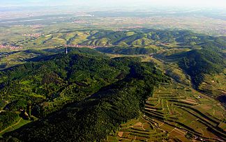
Kaiserstuhl with a skull and the Rhine in the background (aerial view from the southeast) |
|
| Highest peak | Totenkopf ( 556.8 m above sea level ) |
| location | Districts of Emmendingen and Breisgau-Hochschwarzwald ; Baden-Württemberg (Germany) |
| part of | Southern Upper Rhine Lowland , Upper Rhine Lowland |
| Classification according to | Handbook of the natural structure of Germany / Federal Agency for Nature Conservation |
| Coordinates | 48 ° 5 ' N , 7 ° 40' E |
| Type | Low mountain range |
| surface | 100 km² |
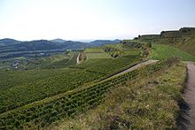
The Kaiserstuhl is one to 556.8 m above sea level. NHN high, small low mountain range of volcanic origin in the Upper Rhine Plain . It rises in the southwest of Baden-Württemberg (Germany), in the districts of Emmendingen and Breisgau-Hochschwarzwald .
Name interpretation
The Kaiserstuhl probably got its name from King Otto III. who held a court day at Sasbach on December 22, 994. After this day of judgment, the whole mountain range was called the “King's Chair”. After Otto III. was crowned emperor in May 996, the "king's chair" became the "emperor's chair". The term “Kaiserstuhl” has only been documented since 1304. Historians assume that the term “Kaiserstuhl” did not come into existence before the 13th century.
geography
location
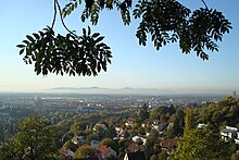
In terms of nature , the Kaiserstuhl is part of the Upper Rhine lowlands and represents the main unit 203 there. It is located in southern Baden for the most part in the Breisgau-Hochschwarzwald district , while the small northern part belongs to the Emmendingen district . Within the Upper Rhine Plain, it is located about 16 km northwest of the city of Freiburg , directly east of the Rhine and a little west of the Dreisam . It rises a maximum of 377.1 m above the Rhine below ( 179.5 m ) the weir near Burkheim .
In its furthest extent from Michaelsberg near Riegel in the northeast to Fohrenberg near Ihringen in the southwest, the Kaiserstuhl is around 15 km long, its greatest width is around 12.5 km.
mountains
The mountains, elevations and their foothills of the Kaiserstuhl include - sorted by height in meters (m) above sea level :
- Totenkopf ( 556.8 m ), 1.9 km east of Bickensohl ; with the Vogtsburg-Totenkopf telecommunications tower and Neunlinden observation tower
- Eichelspitze ( 521.3 m ), 2.8 km northwest of Bötzingen with the Eichelspitzturm
- Katharinenberg ( 491.9 m ), 1.3 km south-southeast of Amoltern
- Bisamberg ( 469.6 m ), 1.2 km south of Amoltern
- Staffelberg ( 447.6 m ), 1.5 km north-north-west of Schelingen
- Badberg ( 432.7 m ) (nature reserve), 1.5 km east of Oberbergen
- Holzeck ( 431.9 m ), 1.7 km north-northeast of Ihringen ; with transmission tower
- Hochbuck ( 375.2 m ), 900 m south of Achkarren
- Schlossberg ( 351.9 m ), 500 m northwest of Achkarren; with castle ruins Höhingen
- Böselsberg ( 340.1 m ), 500 m northwest of Wasenweiler
- Hochberg , ( 288.7 m ), 900 m northeast of Jechtingen
- Büchsenberg ( 283.7 m ), 1.3 km west of Achkarren
Localities
Cities and municipalities with a share in the Kaiserstuhl are (sorted alphabetically):
|
|
geology
The formation of the Kaiserstuhl volcano in the Tertiary is both the climax and the end of the volcanic activity in the Upper Rhine Rift. It began in the Cretaceous period and is evident in numerous volcanic vents that are now deeply eroded . The Kaiserstuhl is the only larger volcano from this period in the Upper Rhine Rift Valley. This meets the Bonndorfer Graben , which leads over the Hegau to Lake Constance. At the end of the Oligocene , magma rose, but still solidified below the surface of the earth. Only in the Miocene did a breakthrough and extensive lava flows occur . From a geological point of view, the Kaiserstuhl can be divided into a sedimentary and a volcanic part. Because of these peculiarities, the Kaiserstuhl was named one of the most important national geotopes in Germany.
Sedimentary base
The almost horizontal sedimentary rocks that form the eastern third were formed long before volcanic activity during the Jurassic and Tertiary periods. Important open stratigraphic units are the main roe stone (mainly in Riegel ) and the Pechelbronn layers (in the area of Bötzingen ). This part of the Kaiserstuhl was sunk less than its surroundings during the formation of the Upper Rhine Graben and represents a so-called eyrie . In terms of structure and sequence of layers, it corresponds to structures in the vicinity equivalent to the Tuniberg and Nimberg to the west and the Schönberg south of Freiburg im Breisgau .
Volcanism
Petrologically , the volcanic Kaiserstuhl is an alkaline rock - carbonatite complex. The volcanic rocks that make up most of the central and western Kaiserstuhl were formed around 19 to 16 million years ago in the Miocene by numerous volcanic eruptions. They partially overlay the sedimentary base of the eastern Kaiserstuhl, which in places has been altered by contact metamorphism , i.e. by exposure to high temperatures. By alternating eruption of Tephra and lava flows from a plurality of vents is a complex layered or formed Stratovolcano . Upwelling magma partially solidified as a sub-volcanic intrusion in the volcanic building and today builds the Central Imperial Chair . Laterally rising phonolithic melts also penetrated the sedimentary base of the eastern Kaiserstuhl. To date, several hundred meters of the original volcano have been removed by erosion.

Volcanic rocks
The entire volcanic Kaiserstuhl consists of foid - and / or olivine- bearing, SiO 2 - undersaturated rocks . The igneous rocks are mostly leucite - tephrite , subordinate also phonolite , limburgite and olivine- nephelinite (on Limberg near Sasbach). The latter is very rich in xenolites from the earth's mantle . A specialty of the igneous rocks are carbonatitic ignimbrites and lapilli , which are exposed in some places in the Westkaiserstuhl (Henkenberg near Burkheim , Kirchberg near Oberrotweil ).
The sub-volcanic intrusions and vein rocks of the central Kaiserstuhl are the deep rock equivalents of the eruption products ( Essexite , carbonatite and coarser-grained phonolite). In the literature there are numerous other names for different varieties of the dike rock ( Alvikit , Hauynophyr, Mondhaldeit, Tinguait, Monchiquit and many others), some of which are not generally recognized rock names. The carbonatite near Altvogtsburg and Schelingen is of great scientific interest . This is a very rare volcanic rock that crystallized not from a silicate but from a carbonate melt. Due to this unusual circumstance, the magmatic nature of carbonatite was not recognized or questioned for a long time. Alternative interpretations were based on contact metamorphic altered sedimentary rocks, which are known to be found in the immediate vicinity. It was not until the 1950s and 1960s that it was possible to reliably identify the rock as carbonatite, among other things by finding the eruptive carbonatites in the western Kaiserstuhl. Because of occurring in him niobium -Minerals Koppit of carbonatite in the middle of the 20th century was tentatively mined. However, the levels turned out to be too low for large-scale use.
Minerals
The Kaiserstuhl has been known for a long time as a site for some rare minerals . Particular sites are the quarries in the Limburgite of the Limberg (various zeolites ), in the carbonatite on the Badberg and Orberg (Koppit) and in the phonolite of the Fohberg and the Kirchberg (zeolites, wollastonite , melanite ). Mostly these occur as fracture minerals or bladder fillings ( almond stone ).
Loess covering
Today the Kaiserstuhl is largely covered by a Quaternary loess layer. Loess is a loose sediment that is formed by the erosion of other rocks and is transported to its place of deposition by aeolian transport . The loess was created - as in the entire edge area of the Upper Rhine Plain - during the last largely vegetation-free Ice Age by blowing out of the Rhine mud. The deposition took place in the periglacial (ice-free, but surrounded by glacier ice) area around the Kaiserstuhl. The main process that takes place in this region is freeze blasting of rocks. Since there is no vegetation that could slow the wind down, it blows strongly. He takes the lightest material with him and deposits it on obstacles such as the Kaiserstuhl. It should be noted that the deposition takes place on the leeward side , in the case of the Kaiserstuhl - where the wind was blowing from the southwest - i.e. in the northeast. The higher the sedimentation site , the thinner the layer of actually deposited material. At the Kaiserstuhl, the loess layer is between 10 and 40 meters thick, but there are also places in the southwest where no loess has been sedimented. The place of origin of the loess at the Kaiserstuhl was mainly in the northern Limestone Alps . A striking feature of the loess is a rust-colored stripe that repeats itself at irregular intervals. This arises from the phased delivery of new material. While a weak sedimentation weathered the top of underlying material, wherein the lime is washed out. Here forms loam . The leached lime fraction precipitates further down in the soil profile and forms the so-called Loesskindel horizon . An enrichment horizon therefore belongs to every precipitation horizon .
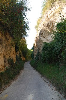
The loess soils of the Kaiserstuhl are used intensively for agriculture because they offer good ventilation and a high water storage capacity as well as good mechanical properties. In addition, the so-called Lösshohlwege were created in the course of agricultural use .
The grown loess is also important for flood protection because it absorbs heavy precipitation like a sponge and then releases it again evenly. However, by creating large terraces for viticulture on the Kaiserstuhl , the loess is compacted with bulldozers and loses this property.
climate
General
Climatically, the Kaiserstuhl belongs to the temperate (moderate) climatic zone. However, due to the preferential heat treatment in the Upper Rhine Plain, it is one of the warmest places in Germany with winters and warm summers that are comparatively mild for Central Europe, with average temperatures of over 20 degrees in the months of July and August. Due to its volcanic soil covered with loess , it is a very good wine-growing region . The climatic conditions of the Kaiserstuhl stand out clearly from its surroundings. It lies in the rain shadow of the Vosges, under the influence of the Burgundian Gate , and therefore has a rather dry climate.
Meteorological data
The annual mean temperature is 9.9 ° C, with 50 to 60 summer days and 60 to 70 frost days being recorded. This already reflects a special feature of the Kaiserstuhl, because it is characterized by quite extreme climatic conditions, which is particularly expressed in the average annual temperature fluctuation of 18.5 ° C. The mean precipitation on the Kaiserstuhl is around 600 to 700 mm, with around 1,720 hours of sunshine annually.
Flora and fauna

The Kaiserstuhl's climate also explains the great abundance of warmth-loving flora and fauna . For example, the Kaiserstuhl is one of the places with the greatest diversity of orchids in Europe - more than 30 species have been registered. Wild grape hyacinths grow between the vines and irises bloom on the slopes . In addition, live bee-eaters , green lizards and mantises ( Mantis religiosa ) - species that have their center of distribution in the Mediterranean area (for new genetic studies are in the green lizard but a likely non-indigenous population of the Eastern green lizard ). The downy oak is a xerophyte and is usually found in southern Europe , but at the Kaiserstuhl it can be kept as a coppice, especially in the downy oak forest on the Büchsenberg. These species live in a disjoint area , i.e. separated from their normal range. This is a relic of a postglacial warm period , during which the area around the Kaiserstuhl also had a significantly warmer climate. After the end of the warm period, the species mentioned could only survive in the Kaiserstuhl. There are also larger populations of the cockchafer at the Kaiserstuhl . Despite criticism from environmentalists, the species was fought with insecticides in the past , for example in 2009. The reason for the action was that the cockchafer could otherwise cause life-threatening damage to the surrounding agriculture.
Protected areas
The Kaiserstuhl has a very high density of nature reserves (NSG). In the center - between the Vogtsburg districts of Schelingen and Oberbergen and the community of Eichstetten a little to the east - are the two largest and directly neighboring areas: The 65-hectare NSG Badberg , which has been in existence since 1969 and has many rare plants (e.g. orchids ) and the NSG Haselschacher Buck , designated in 1989 to the east , which is the largest nature reserve with an area of 71.3 hectares. There are also a number of smaller nature reserves in the Kaiserstuhl. Large parts, especially in its center, belong to the multi-part Fauna-Flora-Habitat- Area Kaiserstuhl (FFH No. 7911-341) and the European bird sanctuary Kaiserstuhl .
| NSG no. | Surname | Area (ha) |
Height (m above sea level ) |
KO | Regulation (date) |
WDPA ID |
|---|---|---|---|---|---|---|
| 3,026 | Amolterer Heath | 11.2 | 300-330 |
|
10/20/1939 | 81304 |
| 3,076 | Badberg | 65.0 | 280-430 |
|
08/09/1969 | 81345 |
| 3.125 | Bitzenberg | 2.7 | 04/18/1983 | 81411 | ||
| 3,049 | Büchsenberg | 11.9 | 07/08/1955 | 81483 | ||
| 3,148 | Badger Holes Buck | 6.4 | 04.09.1985 | 162691 | ||
| 3.152 | Level | 1.6 | 270-280 |
|
11/11/1985 | 162837 |
| 3,180 | Erletal | 2.4 | 220-250 |
|
05/10/1991 | 162998 |
| 3,169 | Haselschacher Buck | 71.3 | 04/11/1989 | 163542 | ||
| 3,109 | Hochberg | 0.7 | 250-270 |
|
09/27/1979 | 81892 |
| 3,087 | Limberg | 28.9 | 08/16/1973 | 82096 | ||
| 3,183 | Oberbergener Scheibenbuck | 5.2 | December 16, 1991 | 164859 | ||
| 3,096 | Ohrberg | 9.6 | December 16, 1976 | 82280 | ||
| 3,069 | Rheinhalde Burkheim | 2.0 | 03/17/1965 | 82403 | ||
| 3,283 | Schelinger Weide-Barzental | 48.9 | 12/29/2012 | 555552566 | ||
| 3,104 | Disc buck-blood buck | 7.4 | December 26, 1978 | 82513 | ||
| 3,103 | Schneckenberg | 2.0 | December 26, 1978 | 82539 | ||
| 3,178 | Niederrotweil quarry | 10.0 | 02/06/1991 | 165703 |
economy

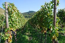
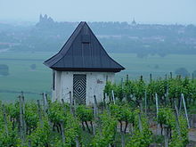
All around and especially in the Kaiserstuhl there is lively viticulture, with the Kaiserstuhl wines now having an excellent international reputation. The vineyards cover most of the free area of the Kaiserstuhl; they are either united in winegrowers' cooperatives or are privately owned or owned by private wineries . Wine thrives particularly well because of the loess soil.
Grown varieties are: Müller-Thurgau , Riesling , Sylvaner , Blue Pinot Noir , Pinot Gris , Pinot Blanc , Gewurztraminer .
Landscape change
The surface of the Kaiserstuhl has been changed by the economic people since it was settled. Since loess is very susceptible to erosion as a result of soil cultivation, terraces had to be created, which were mostly used as vineyards, sometimes also for fruit or arable farming. As a result, the typical small terraced slopes were created early on, which were also traversed by the loess hollow paths , which were also created by "use" .
As part of the land consolidation , it was started around 1950 to merge smaller terraces; this ended in major reallocations, which completely redesigned the original landscape in parts. This redesign began between 1950 and 1960 with small-scale reorganizations. The site was mostly redesigned by hand or with the help of in-house machines. During this time, around 950 hectares were cleared by the land consolidation authorities.
Between 1960 and 1970 the loess slopes were redesigned more comprehensively, with large, deep and as rectangular as possible terrace areas with correspondingly high embankments. The terraces were laid out with a slope on the mountain side, so that now in many cases only the edges are visible from the valley. In this way, around 650 hectares of vineyards were created.
With extensive use of machines, the large terrace plans from 1970 to 1976 were implemented, which significantly changed the landscape. Before these measures, the originally naturally created depressions were still visible in the gentle slopes, the surfaces of which were dominated by the small terraces. Instead of this juxtaposition of natural and man-made structures, the critics now perceive fortress-like and non-landscape surfaces that offer a total size of approx. 630 hectares of vineyards. Since the embankments and other areas were larger than the vineyards, the change in landscape in each case extended to more than twice the newly created usable area. Examples of this phase are the land consolidations Oberrotweil -Oberberg, Ihringen -Abtsweingarten, Eichstetten -Hättlinsberg and Endingen am Kaiserstuhl- Schambach. In the meantime, most of the Lösshohlwege had disappeared due to the land consolidation, which had previously been ecological niches especially for wild bees and birds.
The last phase of the vineyard consolidation extended to the time between 1976 and 1982, during which, among other things, the protests against the large terrace planning were moderated: the embankment heights were "limited" to a maximum of 10 m, the embankment was "curved and adapted to the landscape ". With this method, for example, around 330 hectares of vineyards were worked in Oberbergen -Bassgeige or in Bickensohl -Herrenstück.
After the embankment was damaged by prolonged periods of heavy rainfall from 1977 onwards, in the week of Pentecost in 1983 there was precipitation that sometimes made up a third of the annual mean. This led to damage in the areas covered: the slope surfaces often slipped along with the vegetation, former valley ridges that had been buried by the reallocation were washed out, and deep fractures occurred in individual terraces . In addition, there was frost damage in the following years . Due to the slope of the terrace surfaces on the mountain side, lakes of cold air could form, in which the vines froze to death, especially when they were in bloom. In addition, there was considerable frost damage to the wood of the vineyards, especially in the lower-lying vineyards, where mostly fruit had previously been grown.
The activity of the land consolidation authorities in the period after 1982 was limited to repair work and partial rescheduling, which was intended to correct at least the most serious consequences of the redesign. In the meantime they had also started to designate the remaining Lösshohlwege as natural monuments and to protect them.
Transport links
To the east of the Kaiserstuhl is the federal motorway 5 , from which first state and then district roads lead into the low mountain range. The Kaiserstuhlbahn runs east, north and west and the Breisacher Bahn runs past the Kaiserstuhl to the south .
hike
The best known and “classic” hiking trail is the Neunlindenpfad (north-south path); it is one of eight themed trails and leads from Endingen over the Katharinenberg and the Totenkopf with the Neunlinden observation tower to Ihringen. The paths offer views of the Black Forest , the Rhine plain and the Vosges in many places . The Black Forest – Kaiserstuhl – Rhine path also leads across the Kaiserstuhl.
The Limberg-Weg was laid out in 1977 as a scientific educational trail . It includes 90 stations on the subjects of geology and mineralogy, history, nature conservation and landscape management, forestry, viticulture and fruit growing, Rhine construction and water management, as well as regional studies.
The eight themed trails were opened in 2007 with a total length of 140 km and integrated into the existing network of hiking trails of the Black Forest Association (marking: yellow rhombus on a white background). The network of hiking trails was signposted with 430 new signposts. Large boards with an overview map and location information are set up at central points, for example at train stations in the towns connected or traversed by the theme paths. Each theme path is visually identified by its own color and a symbol corresponding to its name on the entrance portals and the signposts. Another 120 smaller themed panels explain local features along the hiking trails. Local paths, such as the Brunnenpfad (7 km) in Bötzingen , have been integrated into the new network of themed paths .
- Neunlindenpfad (north-south route): Ihringen – Endingen; 16.8 km
- Little Owl Path: Wasenweiler – Riegel; 17.9 km
- Hoopoe trail: Breisach – Sasbach / Limberg; 31.5 km
- Orchid Trail: Breisach – Bötzingen; 21.5 km
- Cherry tree path: Sasbach – Riegel; 18.4 km
- Katharinenpfad: Vogtsburg – Oberrotweil – Bahlingen; 12.6 km
- Badbergpfad: Vogtsburg – Oberrotweil – Nimburg; 14.9 km
- Bee-eater trail: Ihringen – Königschaffhausen; 16.1 km
The eight thematic paths have been supplemented by the Kaiserstuhl path 2010, which as a predicate trail got the seal "Qualitätsweg Walking in Germany". The 21.7 km long Kaiserstuhlpfad, with some extensions, is based on the Neunlindenpfad (north-south path) and leads from Endingen through the Erletal up to the Katharinenkapelle, along the Badberg and Haselschacher Buck nature reserves to the Eichelspitzturm, and on over the Vogelsang Pass to the Neunlindenturm , through the Lößhohlweg Eichgasse to Bickensohl and over the Kreuzenbuck through the Lenzengasse to Ihringen .
literature
- Rainer Goschopf, Odwin Hoffrichter, Angelika Kobel-Lamparski, Jörg-Uwe Meineke: The Kaiserstuhl: Unique loess and volcanic landscape on the Upper Rhine . Ed .: Regional Council Freiburg. 2nd Edition. Thorbecke, Ostfildern 2011, ISBN 978-3-7995-0839-1 .
- Thomas Kaiser and Hans-Peter Schaub: The Kaiserstuhl - natural diversity in an old cultural landscape . Karlsruhe 1997.
- Hans-Otto Mühleisen (Hrsg.): Art at the Kaiserstuhl - Forays through a cultural landscape . 2nd edition, Lindenberg 2008.
- Ingo Seehafer: The Kaiserstuhl: Germany's unique volcanic mountains . 1st edition. Westarp Sciences, 2013, ISBN 978-3-89432-261-8 .
- Georg A. Weth , Kaiserstuhl: The coronation of a lifestyle , Globe-Book-Verlag, Endingen 2005, ISBN 3-9810550-0-4 .
- Horst Stern , photos: Georg Fischer: Kaiserstuhl: The ugly vineyard. In: Geo-Magazin Hamburg 1979,10, pp. 130–156. Historically informative experience report regarding the land consolidation. ISSN 0342-8311 .
- Dirk Wiebel: The Kaiserstuhl - Heat Island on the Upper Rhine , 1997 (PDF, 2.1 MB).
- Otti Wilmanns: The Kaiserstuhl - rocks and flora. 3rd, revised edition, Stuttgart 1989.
Web links
- Natural area profile Kaiserstuhl (203) - LUBW (PDF; 5.1 MB; notes )
- Landscape profile Kaiserstuhl of the Federal Agency for Nature Conservation ( information )
- mitwelt.org: Kaiserstuhl: Nature & Environment, Hikes & Travel
- naturzentrum-kaiserstuhl.de
Individual evidence
- ↑ a b c Map services of the Federal Agency for Nature Conservation ( information )
- ↑ Hans Schneider: About young crust movements in the pre-Alpine landscape between the southern Rhine rift and Lake Constance , In: Mitteilungen der Naturforschenden Gesellschaft Schaffhausen , 1973 and 1975, p. 30
- ↑ Explanations of the geological map of Baden-Württemberg 1: 25,000, sheet Kaiserstuhl. State Office for Geology, Raw Materials and Mining Baden-Württemberg (2002)
- ↑ State Gazette No. 15 of April 24, 2009, p. 10
- ↑ Badberg Nature Reserve , Environment Theme Park Baden-Württemberg, at themenpark-umwelt.baden-wuerttemberg.de
- ↑ a b c Lars Pennig: Effects of land consolidation on nature and viticulture , Geographie Infothek, 2012, accessed on November 29, 2013, on klett.de
- ↑ Mayer 1986
- ↑ R. Moriell: The scientific educational trail at Sasbach a. Rh. , 1978
- ↑ Press release of the German Hiking Association , dated January 14, 2010, accessed on October 10, 2012, from wanderbaren-deutschland.de (PDF; 65 kB).
- ↑ Badische Zeitung: The new season begins in Ihringen Nature Center Kaiserstuhl - Ihringen - Badische Zeitung . ( badische-zeitung.de [accessed on March 10, 2018]).
