
Kocher (river)


The Kocher is the second largest tributary of the Neckar after the water flow and flows, coming from the right from the east, north of Heilbronn .
Surname
The stove was called cooking until the 16th century (795 mentioned as "Cochane", 1024 as "Chochina"). The current form of the name Kocher was occasionally mentioned in the 10th century as "Cochara", from 1504 as "Kocher", and was probably formed under the influence of the river name Necker, an old form of Neckar. The name is likely of Celtic origin. It is placed at the Indo-European word root * keu-k , which means to bend, to bend. The cooker would be the winding river.
geography
Source rivers

The river has its source in Baden-Württemberg at the foot of the Swabian Alb from several karst springs in the Jura . The Schwarze Kocher rises on one south of Oberkochen on the federal road 19 , and the White Kocher on another, a little east of Unterkochen .
The longest branch, furthest from the estuary and with the most water, is the Schwarze Kocher , which appears about 1 km south of Oberkochen on the western valley wall with a discharge that fluctuates between 50 and 4000 liters per second ( origin of the cooker ). It drains large parts of the almost completely forested north-eastern Albuch . Other local tributaries are the only 150 m long and now completely piped Rote Kocher , which is fed by the springs in the Oberkochen oil pond, the Katzenbach and the Langertbach flowing from a side valley . The second major tributary is the White Cooker ; its source outlets are located in two small side valleys east of Unterkochen ( origin of the White Cooker ), it drains approx. 20 square kilometers of the Härtsfeld and joins the Black Cooker in Unterkochen.
In addition to these named source rivers, according to hydrographic criteria, the main source load must be the Lein , as it carries slightly more water at its mouth (3.6 m³ / s compared to 3.4 m³ / s) and the Kocher upper course is about 33 in length up to that point km.
course


The Kocher leaves the Alb between Unterkochen and Aalen and then flows for the next almost 10 km north through the hilly Black and Brown Jura landscape of the Goldshöfer terrace slabs to Hüttlingen . There he turns abruptly to the west and reaches Abtsgmünd , where the Lein flows to him from the left and, a little later, the Blinde Rot from the right . From there it develops valley meanders in the Keuper, reaches Untergröningen , turns more and more to the north, takes the Eisbach from the right in Sulzbach-Laufen and the Fichtenberger Rot from the left just before Gaildorf . In the meantime, in a northerly direction, it leaves the Keuperbergland near Westheim after the beavers flowing towards it from the rose garden and begins its meander valley in the Muschelkalk .
It reaches Schwäbisch Hall , turns briefly to Geislingen am Kocher from north to northeast ("Kochereck") at Untermünkheim and then continues after the inflow of the Bühler from right to Künzelsau- Kocherstetten in the old north direction. There it turns slowly in a wide arc to the west and then south-west to about Öhringen -Ohrnberg, first passes Künzelsau and on this section takes up three larger tributaries from the left: the Kupfer near Forchtenberg , the Sall near Sindringen and finally the near Ohrnberg Unterohrn . The rest of the course of the river goes in a roughly westerly direction, passes Neuenstadt am Kocher , where the Brettach reaches it from the left , and finally flows into the Neckar from the right at Bad Friedrichshall- Kochendorf.
On long stretches of its course, the Jagst accompanies it quite close to the right , which is why only a few larger tributaries reach it from the right.
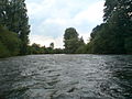
Rapidly flowing stove between Stein and Oedheim
The river dammed by the Oedheimer weir

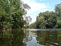
Muzzle into the Neckar Canal


Tributaries
→ Main article: List of the tributaries of the digester

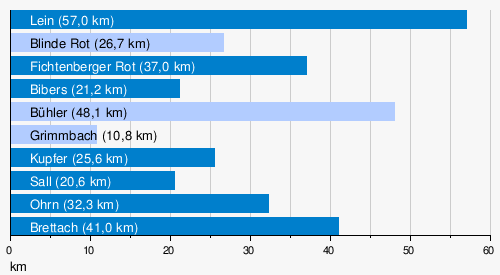
The Kocher has a length of 168 km, a catchment area of 1961 km² and ten tributaries of over 10 km length, namely the Lein with 57 km, the Blinde Rot / Adelmannsfelder Rot with 27 km, the (Fichtenberger) Rot with 37 km, the Bibers with 21 km, the Bühler with 48 km, the Grimmbach with 11 km, the Kupfer with 26 km, the Sall with 21 km, the Ohrn with 32 km and the Brettach with 41 km. Of these, only the Blinde Rot / Adelmannsfelder Rot, the Bühler and the Grimmbach flow to him from the right. The great length of its tributary Lein in the upper reaches is remarkable, which exceeds its own at the point of confluence by more than a factor of 2. With it, the river system of the Kocher reaches a maximum length of 201 kilometers, more than any other tributary of the Neckar.
- Diagram of the inflows to the Kocher with a length of more than 10 km
The tributaries on the left are shown in dark, the ones on the right in light blue.
geology
The sources of the Kocher in the Alb are in the White Jura , which is followed by deeper Jura layers in the foothills of the Alb from around Aalen . At the west bend of the valley near Hüttlingen , the river changes into the Keuper , from around Sulzbach-Laufen in it into the Gipskeuper ( Grabfeld formation ). At Gaildorf it reaches the shell limestone , which only briefly exposes before Westheim in the area of the Neckar-Jagst furrow that crosses the valley and in which it runs almost the rest of the way from that point on; only in the area of the tectonic high altitude layer near its northernmost section occurs between Ingelfingen and Niedernhall on a short stretch in the valley of red sandstone .
Water flow and flooding

Measured by the long-term annual mean of the water flow, the Kocher is the second largest tributary of the Neckar (after the Enz , which comes from the Black Forest with its heavy rainfall and has a larger catchment area). It surpasses its right companion, the Jagst, whose catchment area is narrower. As has been proven by dyeing tests , the Kocher, like its tributary Bühler , draws water underground from the Jagst and its catchment area, the river bed of which is on average around 40 meters higher and runs in karstifiable rocks. At the beginning of the 19th century, because of this water loss from the Jagst near Crailsheim, the river bed at an infiltration point was concreted, as in dry summers the river below it fell almost dry down to Dörzbach, and so there was no water to operate the mills. The close competition from the Jagst makes the Kocher, measured by its length, a river with relatively modest dimensions.
At the Stein gauge, which is ten kilometers above the estuary and where the Kocher already has a 1932 km² catchment area, an annual mean value of 26.2 m³ / s was determined between 1980 and 2003. The discharge values of the individual years can vary greatly. The deviation within the year is even greater; the mean value of the lowest annual runoff is 4.61 m³ / s. Such low runoffs are usually reached in late summer and early autumn, the water flow usually recovers from around October.
In contrast to this are the strong floods of the river. The contribution of the digester to the Rhine flood in 1993 was a discharge of 618 m³ / s on December 21, 1993 (highest previous value). Of the ten highest known values, seven are over 500 m³ / s; five of these seven have been achieved since 1993. 588 m³ / s flowed off on April 14, 1994, 585 m³ / s on December 29, 1947, 544 m³ / s on December 24, 1919, 518 m³ / s on October 30, 1998 March 2002 each reached 514 m³ / s.
nature and environment
Water quality
The water quality is in water quality class II over almost the entire course of the river , there are only deviations in the upper reaches. From the origin of the Schwarzen Kocher the river is even lightly polluted (quality class I-II), from Unterochen it quickly changes through some industrial settlements and their discharges to moderately polluted (quality class II) and even before eels to critically polluted (quality class II-III) . From the Kocher knee in Hüttlingen, the cooker then reaches its usual quality class II. The flax and the smaller tributaries before Gaildorf usually lead to slightly polluted water in the following section. The subsequent tributaries down to the estuary bring almost all moderately polluted water, only the Ohrn critically polluted.
The often brown color of the water in the stove is not due to poor water quality, but rather results from the sludge that is carried along.
biosphere
flora

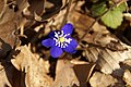
Most of the valley slopes are forested on the upper reaches of the Kocher. The common beech is the dominant tree species. Among other things, the red forest bird grows in these forests . Often only shoots without flowers can be found. The unforested areas are often juniper heaths when they are not used for agriculture . Plants such as the silver thistle , the golden thistle , the centaury , the Carthusian carnation and the common pasque flower can be found here. The grass lily occurs only occasionally . In the middle Kochertal the whorleaved tooth root grows on a damp northern slope . This and a few other occurrences in not far away canyon-like side valleys are the only occurrences of this type in Baden-Württemberg. Both locations are nature reserves, but one of the two occurrences was almost destroyed by extensive clearing. Another rarity is the common chess flower , whose stocks are steadily decreasing in the few locations. The Turk's cap lily blooms from late May to mid-June. The poisonous red foxglove can be found in sunny clearings .
The two spleen herbs grow mostly along the streams that flow into the kettle : alternate and opposed spleenweeds . Opposite-leaved milkweed has a distribution focus in Baden-Württemberg. The nodule saxifrage and globe flower are now showing declining stocks . The two-leaved squill often occurs in larger stands in suitable locations. The Kochertal is the largest of the few areas in Baden-Württemberg where bluestars and liverworts occur together. An extremely rare plant in the middle Kocher valley is the burnt orchid . Many deposits have already died out. The purple orchid is also no longer common.
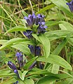
In contrast to the neighboring Jagsttal, the middle and lower Kocher valley has fewer botanical features. Responsible for this is, on the one hand, viticulture, which takes up large areas from Künzelsau, on the other hand, the Kochertal is less "angled" than the Jagsttal. Lean meadows and semi-arid grasslands are therefore rare. Nevertheless, the spring gentian , cross gentian and bee ragwort occur in a few locations .

Bee ragwort

Whorled tooth root
Cross gentian

Opposite milkweed
Hepatica


fauna
The fauna along the Kocher does not differ very much from the neighboring river valleys of the Jagst. In the Kocher Valley between Westheim and Braunsbach , the kingfisher can still find suitable places to dig its brood tubes in the embankments on the bank. In winter a larger colony of the cormorant can be seen on the river bank near Schwäbisch Hall. Kingfishers and cormorants are now also frequently observed in the Ingelfingen area. In the Limpurger Land, the lapwing, which is rare in the Schwäbisch Hall district, nests on a damp meadow at the edge of the stove .
The eagle owl and the peregrine falcon have almost disappeared from the Kocher valley. The few breeding pairs raise their young in disused quarries or on hard-to-reach partial shell limestone walls. There is a larger jackdaw colony in the Großcomburg in Schwäbisch Hall-Steinbach.
The deer , the brown hare , the red fox and the badger are among the most common mammals in the Kochertal. The beaver has recently immigrated, in 2016 in the Schwäbisch Hall urban area on Umlaufberg Neuberg, downstream to the mouth of the Bühler.
A variety of native dragonfly species can be observed at the stove. In addition to the blue-winged demoiselle , the banded demoiselle and the great royal dragonfly , it is, among other things, the blue arrow that hunts over the surface of the leisurely river. In recent years, heat-loving dragonflies such as the fire dragonfly or the small pincer dragonfly have also been detected in the Kochertal.
Further indicators for the global warming of the past decades are the wasp spider's frequent webs of wasp spiders on the meadows in the Kochertal in summer and the flower visits of the wooden bee and the pigeon tail in the surrounding settlements.
The Kocher Valley is home to a large number of native butterflies. In addition to the aurora butterfly , which is active in the spring, the peacock butterfly , the checkerboard butterfly , the small meadow bird and the blue-hacked restorer are particularly common. The pearl grass butterfly , the small kingfisher and the wall fox are not quite as common . In the deciduous forests and in sunny clearings above the river valley, the forest board game and the Russian bear are frequent visitors to flowering plants. In the sunny slopes and pastures above the Kocher valley, rams such as the six-spot ram or the Esparsette ram find a suitable habitat. The swallowtail and the small fire butterfly also stay there more often. In recent years, in early autumn, the postilion immigrating from the south could also be observed on the sunny slopes above the Kocher.
Amphibians such as common frogs , common toads and mountain newts live in damp meadows, swamps and small ponds . The fire salamander will find a biotope tailored to his needs in the surrounding, moist, cool brook blades . The sand lizard and smooth snake can be found at the wayside in the Kochertal . Very often seen is the slow worm . The shy forest lizard is rarely seen.
The following fish (relative frequency in percent) occur in the cooker: gudgeon (21.6%), roach (21.6%), chub (19.4%), arbor (13.5%), tailor (8.3 %), Loach (4.3%), hazel (2.4%), barbel (2.4%), perch (2.2%), bitterling (1.6%), eel , nose , stickleback , bream , pike , minnow , gable , catfish , Koppe , silver bream , stone moroko , tench , rudd , carp , trout , ruffe and perch .
freetime and recreation
water sports
The Kocher has a mostly natural river course, which makes it interesting for canoeists. The increasing interest in recreational sports among the population led to a significant increase in canoeing on the Kocher in the years 2000–2008, all the more since traffic restrictions have been in effect on the neighboring Jagst since May 10, 2001. In July 2006, over 200 boats were counted on the stove. In 2014, on the Braunsbach-Künzelsau section, the Stuttgart Regional Council counted an average of around 10 boats a day.
In order to avoid overloading the stove due to canoe tourism, the community of Braunsbach, the Schwäbisch Hall district office and various associations have issued the following access regulations:
- Access only when the water level is over 40 cm, measured at the Kocherstetten gauge at 8 a.m. (summer time) the day before or the day of the journey
- Falling below the minimum level twice means an immediate driving ban.
- Driving and entering (with boats) of the approx. 400 m long section from the Braunsbach weir downstream when the water level is below 60 cm, measured at the Kocherstetten gauge.
- Insertion, landing and resting only at marked points
- If possible, drive on between 9:00 a.m. and 6:00 p.m.
- Drive in the middle of the river; Avoid bank areas and sand and gravel banks
- Drive through the Grimmbach estuary nature reserve quickly and calmly
- Canoeists are asked to avoid prolonged stays on kingfisher breeding walls (see section “Fauna” ).
outdoor pool
In Künzelsau there is also an outdoor river pool at the Kocher.
Sights and buildings
- Celtic ramparts Kocherburg near Unterkochen
- Limes Museum in Aalen
- Hohenstadt Castle , Heckengarten and pleasure palace
- Untergröningen Castle
- Gaildorf with the old castle
- Comburg Monastery in Schwäbisch Hall
- Schwäbisch Hall with the historic old town in the valley
- Archebrücke from Obergröningen -Fach, built in 1886, moved to the Kocher between Gelbingen and Untermünkheim in 1988/89
- At Geislingen am Kocher , the 185 meter high Kochertal bridge - the highest bridge in Germany - spans the valley.
- Döttingen Castle in Braunsbach- Döttingen
- Tierberg Castle , settlement area of the community of Braunsbach
- Stetten Castle via Kocherstetten
- Niedernhall , a listed, medieval old town with city wall and battlements
- Neuenstadt Castle in Neuenstadt am Kocher , once the seat of the Dukes of Württemberg-Neuenstadt
- Naturstromspeicher Gaildorf , wind park with four wind turbines with integrated pumped storage plant
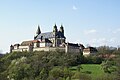
The Großcomburg in Schwäbisch Hall

Schwäbisch Hall, part of the stove

Schwäbisch Hall market square
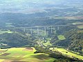
Kochertal bridge on the A 6
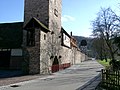
City wall of Niedernhall

Neuenstadt am Kocher, castle


economy

The industrial importance of the river is rather low. Apart from touristic canoe tours, it is not used by ships because it is too narrow and deep. Wine is grown on the southern slopes around Ingelfingen and Niedernhall , the location is called Kocherberg . The wine is marketed almost exclusively through the local cooperatives; the Kochertal winery in Ingelfingen is the largest in the Württemberg wine-growing area of Kocher-Jagst-Tauber.
The signposting and expansion of the Kocher-Jagst cycle path (consisting of two valley cycle paths) has contributed greatly to the upswing in tourism in the region.
Rafting on the stove

Due to the enormous wood requirements of the Halle salt boilers , firewood was rafted on the river very early on . In 1399, in a contract between the Limpurg taverns and the town of Hall, the Haalfloß is already described as of old tradition. Blocks about 3 m long and between 10 and 50 cm thick were rafted. Every year around 600,000 of these logs were transported on the river.
The technical development of some tributaries (including Lein, Blinde Rot and Fichtenberger Rot) contributed to the large amount; the stove itself was floatable from Abtsgmünd. Since the water level of these rivers was often insufficient for rafting, swell ponds (drifting lakes) were built on the upper reaches, which dammed water and could generate the "surge" necessary for rafting. Examples of this in the catchment area of the Kocher are the Treibsee near Bühlerzell and the Bergsee near Gschwend .
A special feature of the rafting on the cooker was the so-called raft mark - several uniquely arranged notches - which was attached to each log. In Hall, each block of wood was checked when it was pulled out and credited to the thrower.
See also
- List of the tributaries of the Neckar
- Kochertalbrücke (highest valley bridge in Germany)
Individual evidence
- ↑ According to the LUBW's online waterway map, see the web links.
- ↑ Topographic map 1: 25,000 sheets 7023
- ↑ Topographic map 1: 25,000 sheets 7126
- ↑ a b Ministry for the Environment, Climate Protection and Energy Sector Baden-Württemberg: Expansion potential of hydropower up to 1,000 KW in the Neckar catchment area, taking into account ecological management objectives ( memento of the original from October 29, 2013 in the Internet Archive ) Info: The archive link was automatically inserted and still Not checked. Please check the original and archive link according to the instructions and then remove this notice. , 2011, p. 9, accessed on June 29, 2013 (pdf, German, 1.87 MB)
- ^ German Hydrological Yearbook Rhine Region, Part I 2009 State Institute for Environment, Measurements and Nature Conservation Baden-Württemberg, p. 127, accessed on January 22, 2016 (PDF, German, 1.85 MB).
- ↑ Dieter Berger: Geographical Names in Germany (= Duden pocket books , volume 25). 2nd Edition. Dudenverlag, Mannheim ( inter alia) 1999, ISBN 3-411-06252-5 , p. 16; - Albrecht Greule : German water names book. Etymology of the water body names and the associated area, settlement and field names. De Gruyter, Berlin / Boston (Mass.) 2014 ISBN 9783110190397 , p. 275.
- ↑ Abtsgmünd gauge 1.2 km above the estuary
- ↑ Derivation from the data of the Abtsgmünd and Wöllstein gauges, as well as the catchment areas of the Lein and Kocher at the confluence and the difference area to the Wöllstein gauge
- ↑ Map server "LUBW-RIPS" of the State Office for the Environment Baden-Württemberg ( Memento of the original from July 4, 2009 in the Internet Archive ) Info: The archive link was inserted automatically and has not yet been checked. Please check the original and archive link according to the instructions and then remove this notice.
- ↑ Geology according to map server of the State Office for Geology, Raw Materials and Mining (LGRB) ( notes ). The layers of the Geological Map 1: 50,000 rubric show the geology even at a finer resolution, in which the main map is hidden.
- ↑ Biological water quality map 1: 350,000 of the State Institute for Environmental Protection Baden-Württemberg (PDF; 11.7 MB)
- ^ Haller Tagblatt dated February 13, 2017
- ↑ Fishery management concept Kocher (PDF; 1.6 MB)
- ↑ Canoe tourism on the Kocher , Katharina Jüttner, 2007 (PDF; 3.2 MB)
- ↑ Information sheet for canoeists on the Kocher (PDF; 158 kB)
- ↑ Current traffic regulations ( page no longer available , search in web archives ) Info: The link was automatically marked as defective. Please check the link according to the instructions and then remove this notice. of the Canoe Association Württemberg (PDF)
- ↑ Matthias Stolla: Kocher pool single river pool in the country. In: Stimm.de/Hohenlohe
literature
- Bernhard Lott: The cooker from the source to the mouth. Swiridoff, Künzelsau 2002, ISBN 3-934350-80-1 .
- Swabian-Franconian Forest Nature Park. 4th edition. Theiss, Stuttgart 2006, ISBN 3-8062-2033-6 .
Web links
- Level data: State Institute for the Environment Baden-Württemberg .
- Andreas Etzold: Explanations for sheet 7126 Aalen of the geological map 1: 25,000 of Baden-Württemberg . State Office for Geoinformation and Rural Development Baden-Württemberg , Stuttgart 1980.
- Water network in the data and map service of the LUBW
- The Kocher - the lifeline of the Ostalb district ( Memento from September 28, 2007 in the Internet Archive )
- Fishery conservation concept Kocher ● Hegegemeinschaft Kocher ● Marco Sander (qualified biologist) (PDF file; 1.55 MB)
- Text volume (PDF file; 499 kB) and appendix volume (PDF file; 417 kB) from EU - Water Framework Directive Report on the inventory of the Neckar processing area, sub-processing area 47 (Kocher)