
La Tour d'Auvergne
| La Tour d'Auvergne | ||
|---|---|---|
.svg)
|
|
|
| region | Auvergne-Rhône-Alpes | |
| Department | Puy-de-Dôme | |
| Arrondissement | Issoire | |
| Canton | Le Sancy | |
| Community association | Dômes Sancy Artense | |
| Coordinates | 45 ° 32 ' N , 2 ° 41' E | |
| height | 719-1,691 m | |
| surface | 48.29 km 2 | |
| Residents | 640 (January 1, 2017) | |
| Population density | 13 inhabitants / km 2 | |
| Post Code | 63680 | |
| INSEE code | 63192 | |

La Tour d'Auvergne is a French commune of 640 inhabitants (at January 1, 2017) in the department of Puy-de-Dôme in the region Auvergne Rhône-Alpes . It belongs to the Arrondissement of Issoire and the Canton of Le Sancy .
The municipality is part of the Volcans d'Auvergne Regional Nature Park .
history
La Tour-d'Auvergne was originally called La Tour and is the ancestral home of the House of La Tour, later the House of La Tour d'Auvergne , the name of which was changed by the place.
Population development
- 1962: 957
- 1968: 1,025
- 1975: 858
- 1982: 824
- 1990: 778
- 1999: 719
- 2013: 653
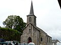
Saint-Louis church

Saint-Pardoux church
.JPG)
.JPG)
Web links
Commons : La Tour-d'Auvergne - Collection of images, videos and audio files