
Monthyon
| Monthyon | ||
|---|---|---|
.svg)
|
|
|
| region | Île-de-France | |
| Department | Seine-et-Marne | |
| Arrondissement | Meaux | |
| Canton | Claye-Souilly | |
| Community association | Pays de Meaux | |
| Coordinates | 49 ° 1 ′ N , 2 ° 50 ′ E | |
| height | 89-168 m | |
| surface | 12.11 km 2 | |
| Residents | 1,707 (January 1, 2017) | |
| Population density | 141 inhabitants / km 2 | |
| Post Code | 77122 | |
| INSEE code | 77309 | |
| Website | http://www.monthyon.fr/ | |
 City Hall (Mairie) of Monthyon |
||

Monthyon is a French commune with 1,707 inhabitants (as of January 1 2017) in the department of Seine-et-Marne in the region Ile-de-France . It belongs to the Arrondissement of Meaux and the canton of Claye-Souilly (until 2015: canton of Dammartin-en-Goële ). The inhabitants are called Monthyonnais .
geography
Monthyon is about 39 kilometers east-northeast of Paris . Monthyon is surrounded by the neighboring communities Gesvres-le-Chapitre in the north, Barcy in the east, Penchard in the south-east, Chauconin-Neufmontiers in the south, Le Plessis-l'Évêque in the west and Saint-Soupplets in the north-west.
The national route 330 runs through the municipality .
Population development
| year | 1962 | 1968 | 1975 | 1982 | 1990 | 1999 | 2006 | 2012 |
| Residents | 769 | 792 | 858 | 1,039 | 1,176 | 1,337 | 1,604 | 1,652 |
| Source: Cassini and INSEE | ||||||||
Attractions
- Saint-Georges church from the 16th century
- Monthyon Castle from the 17th / 18th centuries Century, built on the earlier castle from the 12th century
- L'Hôpital manor
- Villa La Grimpette, built in the early 19th century
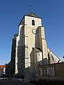
Saint-Georges church

Montyon Castle

Villa La Grimpette


Personalities
- Antoine-Jean-Baptiste-Robert Auget (1733-1820), economist
- Eugène Boch (1855–1941), painter
- Jacques Chazot (1928–1993), writer and dancer
- Jean-Claude Brialy (1933–2007), actor and director, died there
literature
- Le Patrimoine des Communes de la Seine-et-Marne. Flohic Editions, Volume 1, Paris 2001, ISBN 2-84234-100-7 , pp. 411-413.
Web links
Commons : Monthyon - collection of pictures, videos and audio files