Méry-sur-Marne
| Méry-sur-Marne | ||
|---|---|---|

|
|
|
| region | Île-de-France | |
| Department | Seine-et-Marne | |
| Arrondissement | Meaux | |
| Canton | La Ferté-sous-Jouarre | |
| Community association | Coulommiers Pays de Brie | |
| Coordinates | 48 ° 58 ′ N , 3 ° 12 ′ E | |
| height | 52-196 m | |
| surface | 5.79 km 2 | |
| Residents | 670 (January 1, 2017) | |
| Population density | 116 inhabitants / km 2 | |
| Post Code | 77730 | |
| INSEE code | 77290 | |
| Website | http://www.mery-sur-marne.fr/ | |
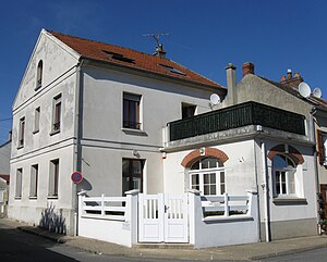
 Town hall ( Mairie ) of Méry-sur-Marne |
||
Méry-sur-Marne is a French commune with a population of 670 (as at 1st January 2017) in the department of Seine-et-Marne in the region Ile-de-France . It belongs to the arrondissement of Meaux and the canton of La Ferté-sous-Jouarre . The inhabitants are called Merycards .
geography
Méry-sur-Marne is about 21 kilometers east-northeast of Meaux in an arch of the Marne , which borders the municipality in the south. Méry-sur-Marne is surrounded by the neighboring communities of Sainte-Aulde in the north and north-west, Bézu-le-Guéry in the north, Nanteuil-sur-Marne in the east and north-east and Saâcy-sur-Marne in the south and east and Luzancy in the west.
Population development
| year | 1962 | 1968 | 1975 | 1982 | 1990 | 1999 | 2006 | 2017 |
| Residents | 286 | 363 | 374 | 378 | 492 | 483 | 581 | 670 |
| Sources: Cassini and INSEE | ||||||||
Attractions
- Saint-Rémy church
literature
- Le Patrimoine des Communes de la Seine-et-Marne. Flohic Editions, Volume 1, Paris 2001, ISBN 2-84234-100-7 , pp. 548-549.
Web links
Commons : Méry-sur-Marne - Collection of images, videos and audio files

