
Pierre-Levée
| Pierre-Levée | ||
|---|---|---|
.svg)
|
|
|
| region | Île-de-France | |
| Department | Seine-et-Marne | |
| Arrondissement | Meaux | |
| Canton | La Ferté-sous-Jouarre | |
| Community association | Coulommiers Pays de Brie | |
| Coordinates | 48 ° 54 ' N , 3 ° 2' E | |
| height | 142-172 m | |
| surface | 12.93 km 2 | |
| Residents | 470 (January 1, 2017) | |
| Population density | 36 inhabitants / km 2 | |
| Post Code | 77580 | |
| INSEE code | 77361 | |
| Website | http://www.pierre-levee.fr/ | |
 Town hall (Mairie) by Pierre-Levée |
||

Pierre-Levée is a French municipality with 470 inhabitants (as of January 1, 2017) in the department of Seine-et-Marne in the region Ile-de-France . It belongs to the Arrondissement of Meaux and is part of the canton of La Ferté-sous-Jouarre . The inhabitants are called Pierrelevéen (ne) s .
geography
Pierre-Levée is about twelve kilometers east-southeast of Meaux and about 55 kilometers east-northeast of Paris . Pierre-Levée is surrounded by the neighboring communities of Saint-Jean-les-Deux-Jumeaux in the north, Signy-Signets in the northeast, Jouarre in the east and northeast, Giremoutiers in the south, La Haute-Maison in the west and southwest and Villemareuil in the northwest.
Population development
| year | 1962 | 1968 | 1975 | 1982 | 1990 | 1999 | 2006 | 2013 |
| Residents | 265 | 242 | 207 | 275 | 322 | 354 | 427 | 483 |
| Source: Cassini and INSEE | ||||||||
Attractions
- Saint-Claude church (see also: List of Monuments historiques in Pierre-Levée )
- Montebise Castle

Saint-Claude church
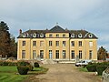
Montebise Castle


literature
- Le Patrimoine des Communes de la Seine-et-Marne. Flohic Editions, Volume 1, Paris 2001, ISBN 2-84234-100-7 , p. 550.
Web links
Commons : Pierre-Levée - Collection of images, videos and audio files