
Most (Czech Republic)
| Must | |||||
|---|---|---|---|---|---|
|
|||||
| Basic data | |||||
| State : |
|
||||
| Historical part of the country : | Bohemia | ||||
| Region : | Ústecký kraj | ||||
| District : | Must | ||||
| Area : | 8694.121 ha | ||||
| Geographic location : | 50 ° 30 ' N , 13 ° 38' E | ||||
| Height: | 233 m nm | ||||
| Residents : | 66,186 (Jan 1, 2019) | ||||
| Postal code : | 43401-43502 | ||||
| License plate : | U | ||||
| traffic | |||||
| Street: | I / 13 | ||||
| Railway connection: | Ústí nad Labem - Chomutov | ||||
| structure | |||||
| Status: | Statutory city | ||||
| Districts: | 8th | ||||
| administration | |||||
| Lord Mayor : | Jan Paparega (as of December 2014) | ||||
| Address: | Radniční ul. 1 434 69 Most |
||||
| Municipality number: | 567027 | ||||
| Website : | www.mumost.cz | ||||
| Location of Most in the Most district | |||||

|
|||||


Most ( German Brüx ) is an industrial town in the Ústecký kraj (Aussiger region) in northern Bohemia .
geography
Geographical location
The city of Most in Okres Most is located on the Bílina (Biela) river in the North Bohemian Basin .
City structure
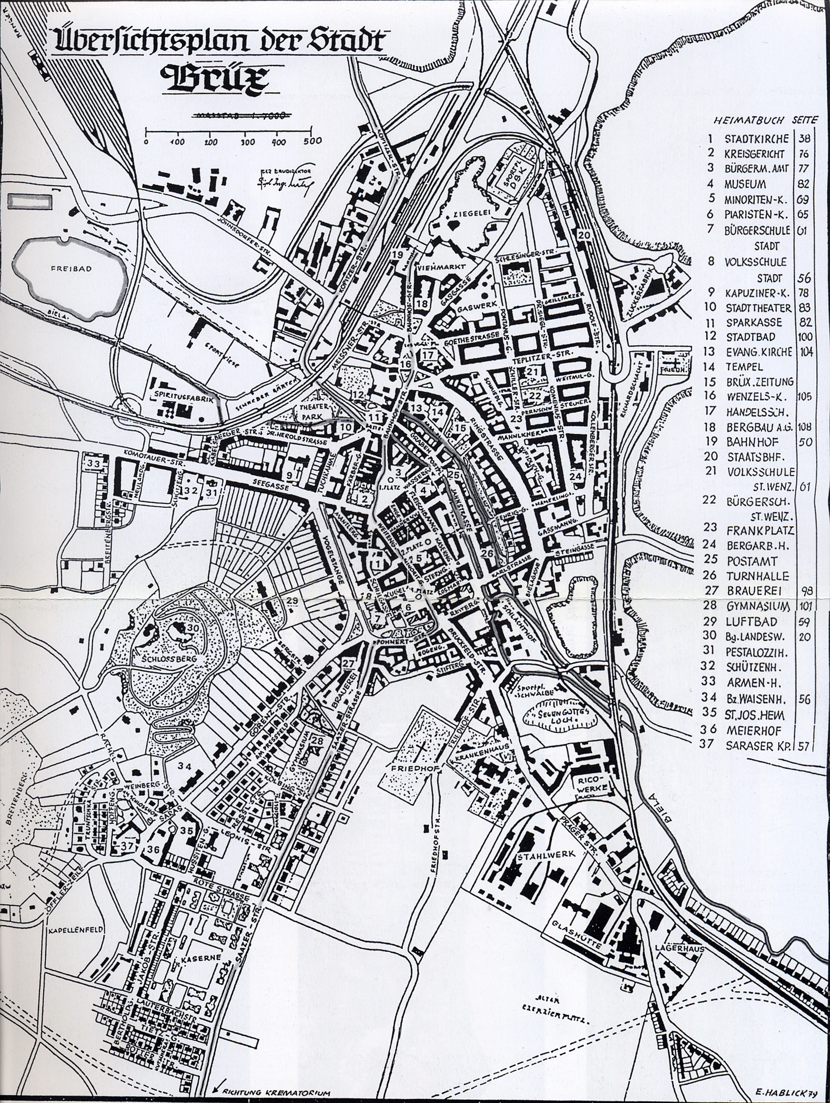
The city of Most consists of eight districts with 61 basic settlement units. The urban area is divided into 18 cadastral districts.
Districts and cadastral districts
- Čepirohy; Cadastre: Slatinice u Mostu (German Zlatnik) , Čepirohy (Tschöppern) and partly Hořany (Hareth)
- Komořany; Cadastre: Dřínov u Komořan (Bartelsdorf) , Ervěnice (Seestadtl) , Komořany u Mostu (Kommern) and Třebušice (Triebschitz)
- Must; Cadastre: Most II and partly Hořany (Hareth)
- Rudolice; Cadastre: Rudolice nad Bílinou ( Rudelsdorf ad Biela )
- Souš; Cadastre: Souš (Tschausch) and partly Hořany (Hareth)
- Starý Most (formerly Kopisty); Cadastre: Most I, Konobrže (Kummerpursch) , Kopisty (copyist) , Pařidla (Paredl) and Střimice (Strimitz)
- Velebudice; Cadastre: Skyřice (Skyritz) and Velebudice (Welbuditz)
- Vtelno; Cadastre: Vtelno (Wteln)
Basic settlement units are Autodrom, Benedikt, Čepirohy, Čepirohy-západ, Čepirožská výšina-jih, Dopravní podnik, Dostihové závodiště-východ, Dostihové závodiště-zářéz, Konovodiště-zářyz, Konovodiště-zářyka, Konovodiště-zářka, Konovodiště-zářížany, Hořín-Komov, Fibovářka, Dřín-Komo, Fibráchany, Keovovichypany výchany. Kopistská výsypka-západ, Kopisty, Koridor, Lajsník, Lesopark Hrabák, Liščí vrch, Most-pod nemocnicí, Na Novém světě, Na Ovčíně, Na sadech, Nad nádražím, Nákladové, Nádražím, Nákladové, Pod nádraclaží, Nákladové, Pod nádrazízím, Pod nádrazízím, Pařiben, Obrabák, Lesopark Hrabák, Lesopark Hrabák, Pod Širokým vrchem, Podžatecká-jih, Podžatecká-sever, Průmyslový obvod Bylany, Ressl-východ, Ressl-západ, Rudolice, Sídliště Chanov, Skřivánčí vrch, Skyřice, Slatinice, Souš, Starý výchý, Střkrchedý, Střkrchy Třebušice, U hřbitova, U kostela, U koupaliště, U muzea, U stadiónu, Velebudice, Vrch Hněvín, Vtelno, Výsluní and Zahražany.

history
12-14 century
The Czech word Most means "bridge". The city of Brüx was created in connection with the so-called state development in the southern Erzgebirge foothills and in the Erzgebirge at the end of the 12th and beginning of the 13th century. The state development was part of the medieval German eastern settlement . The city was probably laid out in the 1220s by the Hrabischitz dynasty with the support of the monastery of the Kreuzherren von Zderaz in Prague . According to archaeological research , a wooden bridge allegedly crossed by Ibrahim ibn Jakub to Prague at the end of the 10th century and from which the city is said to take its name is now a legend.
Kojata von Brüx , the last descendant of the Hrabischitz family, bequeathed all of his fortune to the monastery of the Zderaz Cross Lords in 1227 . Probably in 1229 and at the latest in 1238, the town passed into the possession of the Přemyslids . The oldest archaeological evidence from the excavations in the old town center also dates from the 1230s to 1250s. The oldest town seal dates from 1257. Brüx was a rich medieval royal town with all the rights granted to the town by Ottokar II Přemysl , Johann von Luxemburg and Charles IV . At the end of the 14th century, vineyards were planted along the town . As a result of the resettlement, most of the residents were German .
15-17 century

In the Hussite Wars (1419–1434), Brüx was a center for Catholics. In the period from 1455 to 1515 there were several major fires in the city. During the rapid urban renewal in 1517, Master Jacob Haylmann von Schweinfurt began to build a new deanery church. A new renaissance style town hall was also built. In 1571 Heinrich von Maltitz sat on Brüx and in that year acquired the rule and castle Hoyerswerda in Upper Lusatia. During the Thirty Years' War the city was conquered several times by Swedish troops. In 1646, the castle was on the castle hill for the first and last time Castle Hněvín (state observatory) conquered. The conquerors achieved this through a ruse.
18. – 19. century
After the Thirty Years War, the city lost its economic and political importance. In the second half of the 19th century, during the industrialization of Germany , coal mining and industry changed the character of the city (sugar factory, porcelain factory, steel mill, brewery). The city museum was founded. In 1870, Brüx received its first railway connection through the Aussig-Teplitz Railway. Especially for the expanding coal mining industry, many workers, predominantly of Czech nationality, were hired to move to Brüx. Around 1930 the seventy years previously purely German city had a narrow Czech majority.
During the floating sand disaster at Brüx on the night of July 19-20, 1895 (9:15 p.m. to 6:00 a.m.), the ground in the northern part of the city sank considerably. Residential buildings, streets and what was then the train station were affected with dramatic effects. The abgeglittene quicksand flowed into stopes of the mine Annahilfsbau and further into the distance forays this mine. Almost 2,500 people were left homeless and three residents died. 25 houses sank, 13 other buildings suffered considerable damage. Similar incursions occurred here in 1896 and 1897. The cause is considered to be a special geological deposit situation in the region, which was made effective by coal mining.
In 1898 the "North-West Bohemian Exhibition for Industry and Commerce" took place in Brüx.
20th century

In 1900 the dressing material factory RICO was built; in 1901, the cities of Most and Kopitz ( Kopisty ) were connected to Johnsdorf ( Janov u Litvínova ) by a tram . In 1911 the then most modern theater building in Austria-Hungary was opened; the drinking water supply of the city was solved from 1911 to 1914 by the construction of the dam Brüx in Kreuzweg ( Křížatky ).
After the First World War, Brüx belonged to the province of German Bohemia for a few weeks . In no other largely German city in Bohemia was the resistance against the Czech occupation as great as here. A first attempt at occupation on November 26th, 1918 by weak Czech troops was rejected by the Brüxer Volkswehr without a fight. On November 27th, battalion-strength Czech military attacked the city from the northeast. After hours of street fighting, the much inferior Volkswehr had to surrender in the late afternoon. The last Germans did not surrender until November 28, after threats had been given to bombard the city with artillery. On the German side there were six dead and several injured; the number of Czech victims is unknown.
On March 4, 1919, demonstrations were also held in Brüx for the right of peoples to self-determination and against the Czech occupation. Unlike in nearby Kaaden , the demonstration in Brüx was not crushed.
Brüx was expanded rapidly until the Great Depression in 1929. Because of the poor economic situation , many residents emigrated to North America or Australia at the beginning of the 1930s. In the Munich Agreement of autumn 1938, the Sudetenland fell to the German Reich , and Brüx was the seat of the district of Brüx , the district of Aussig in the Reichsgau Sudetenland .
Operator of the lignite -Bergwerke (essentially open pit ) in the North Bohemian basin was from June 1939 to the public realm works Hermann Goering belonging Sudetenland Bergbau AG (SUBAG) based Brüx. To the north of it, in the district of Maltheuern, the Sudetenlandische Treibstoffwerke AG (STW) Oberleutensdorf, which was created with a majority stake by SUBAG, built a hydrogenation plant (today Unipetrol RPA - refinery, petrochemicals, agrochemicals) to produce gasoline, diesel and heating oil by liquefying coal . The plants, which were not fully expanded until 1943, had an annual capacity of 335,000 t of synthetic gasoline (mainly aviation gasoline) and were therefore a frequent target of heavy attacks in the aerial warfare of World War II , which caused considerable damage in the area from 1944 onwards. Many German Brüxers and several hundred non-German forced laborers were killed.
From September 1, 1944 to October 7, 1944, there was a satellite camp of the Flossenbürg concentration camp , whose 1,000 prisoners had to do forced labor for the Sudetenländische Bergbau AG in Seestadtl.
On April 1, 1941, the neighboring town of Kopitz and the communities of Rudelsdorf an der Biela , Strimitz and Tschausch were incorporated into the town of Brüx.
After the Second World War , almost the entire German-speaking population was expelled . Her property was confiscated by Beneš Decree 108 and the Catholic Churches of Brüx in Czechoslovakia expropriated .
Many new citizens from Central Bohemia, Slovakia, so-called "repatriants" and Roma settled here. In the 1950s, new settlements were built below the Castle Hill (Hněvín).
In 1964, the Czechoslovak government decided to demolish the old town, and from 1967 to 1982 the city was gradually completely demolished in favor of coal mining and rebuilt as a prefabricated building two kilometers south.
Part of the demolition work was carried out by a film team from Metro-Goldwyn Mayer for the production of the Hollywood film Die Brücke von Remagen . The film team shot the fight for downtown Remagen in Most. During the shooting, film technicians blew up buildings in rows while the film soldiers played war.
The new city

The Jan Hus shaft was created to accommodate open-cast coal mining, which forced the removal of the old town and destroyed all historical structures. After the city center was blown up in the early 1970s, an old residential area from the end of the 19th century below the castle and a number of buildings from the 1920s were preserved.
Life in Brüx / Most and the entire region was shaped by heavy industry, coal mining and the chemical industry. At the end of the 20th century, a reorientation towards light industry and services began. However, the focus is still on lignite mining and the recultivation of the landscape devastated by the opencast mine.
Recultivated areas are used for recreation and swimming purposes, but also for fruit and wine growing. The Autodrom Most is especially well known among motorsport enthusiasts . At the time of the Iron Curtain, the events on this racetrack were also a very popular meeting place for motorsport fans from the GDR .
The city theater that was built in the new city is a modern building that has become Most's landmark.
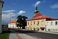
On the local mountain of Brüx, the Hněvín (castle hill), there is the Landeswarte castle, but this is not a medieval castle, but a historicizing restaurant from 1906, in which preserved parts of the old castle ruins were included.
Across from Hněvín, the Orthodox Church of St. Valentin erected; the wooden church was destroyed on October 29, 2017 by the autumn storm Herwart , which tore down the 23 m high church tower.
Demographics
Until 1945, Brüx was mostly populated by German Bohemia , which were expelled.
| year | Residents | Remarks |
|---|---|---|
| 1830 | 2,749 | in 437 houses |
| 1845 | 3.130 | in 446 houses |
| 1857 | 4,984 | on October 31st |
| 1900 | 21,516 | including 4,164 (19%) Czechs |
| 1910 | 25,577 | including 3,965 (15%) Czechs |
| 1921 | 27,239 | of which 17,014 (62%) Germans |
| 1930 | 28,212 | including 9,740 (35%) Czechs |
| 1939 | 22,422 | 1,880 Protestants, 18,340 Catholics, 269 other Christians and 34 Jews |
politics
Town twinning
-
 Meppel , Netherlands
 -
 Marienberg , Saxony, Germany
Culture and sights

Theaters and museums
- City Theater, Divadelní 15
- Regional Museum, Čsl. armády 1360/35
Buildings
See also: List of listed objects in Most
Church of the Assumption
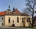
All that remains of the old Brüx is the historically valuable deanery church of the Assumption of the Virgin Mary , the former parish church , which was moved 841 m on an arched railroad track in 1975 in a spectacular action and at great expense without its foundations. As a result, their alignment at their new location deviates from the original position by 90 °.
Next to the Marienkirche is the former hospital church of the Holy Spirit from the 14th century.

Church in the old city center

Before the shift, the west tower and the bell tower were demolished.

View of the Assumption from the castle (2011)

Assumption of Mary (2013)

Interior view of the main altar
Former hospital church of the Holy Spirit


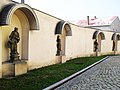
Sculptures at the Assumption Church
The following sculptures were re-erected at the Marienkirche:
- Statue of St. John of Nepomuk with the statues of the patron saint St. Wenceslas and St. Adalbert
- baroque group of sculptures of St. John of Nepomuk with the statues of St. Charles Borromeo and St. Elisabeth (18th century), originally at the lake gate in Alt-Brüx
- Statues of the Seven Virtues and St. Franz von Assisi by Karl Waitzmann (1770), originally in the Minorite monastery in Alt-Brüx
- Plague column or torture column

Statue of St. John of Nepomuk

Sculpture group of St. John of Nepomuk
Statues of the Seven Virtues and St. Francis of Assisi
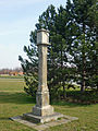
Plague column

Baroque scapegoat sculpture, now in the Heiliggeistkirche


Sculptures in the new town of Most
The following sculptures were repositioned in the Neustadt:
- Marian column with statues of the patron saint
- Plague column of St. Anna herself by Peter von Toscana (1681), surrounded by the statues of the plague saint , St. Rosalie of Palermo , St. Agnes of Rome , St. Sebastian and St. Rochus in memory of the plague of 1680, originally on the 1st square (market), now on the theater square at the new city theater
- Baroque sculptures of the four elements by Johann Brokoff (1715), originally on the back of the former mayor's office, now on the new magistrate building

Marian column

Plague column of St. Anna herself the third

Four elements - earth

Four elements – air
Four elements - water

Four elements - fire


Autodrom Most
The Autodrom Most is a permanent racing circuit that is located in the immediate vicinity of the city of Most. In the summer of 2016, the race track, famous for hosting the “Czech Truck Prix”, celebrated its 33 year anniversary.
Former sights of Alt-Brüx
The following former architectural monuments were demolished:
- Mayor's office on I. Platz (Alter Markt - Vorderer Ring)
- baroque Franciscan monastery with the church of St. Franziskus Seraphikus ( Minoritenkirche ) at II. Platz (Holzmarkt - Mittlerer Ring, also Minoritenplatz)
- Piarist Church (former Magdalenerinnen Monastery Church ) on III. Square (New Market - Bohemian Ring)
- Originally Romanesque, later Baroque-style Wenceslas Church ( Order of the Cross ) on Wenceslas Square in the former suburb
- Bell tower next to the deanery church of the Assumption
- City theater on Smetanaplatz
- late Gothic Church of St. Anne
- Capuchin Church in the former Seegasse
- Protestant church
Economy and Infrastructure
Companies
During the founding period, numerous factories were built here, most of which no longer exist today:

- Sudetenland Sugar Company, Brüx, founded in 1828
- Porcelain and stoneware factory Carl Spitz (1882), Prager Str., See location (location)
- First Brüxer Maschinenfabrik AG, Brüx (1890)
- Rico-Werke (1900), Prager Str., Now Hartmann-RICO, Kostelní 658 (at the original location), belonging to the Hartmann Group , location see (location)
- Brüxer Straßenbahn- und Elektrizitäts AG, Brüx (1900)
- North Bohemian Coal Works-AG, Brüx
- Brewery (brewing community Brüx), Saazer Str.
- Alcohol and potash factory, Komotauer Str.
- Glassworks in the former Prague suburb
- Steel mill in the former Prague suburb
- Porcelain manufacture in the former Prague suburb, Wtelner Weg
- Enamel factory "Sphinx", Paredler Str.
The settlement of companies is currently concentrated in the industrial area "Joseph", southwest of the city on trunk road I / 27.
traffic
Most has a hub station, which is served almost every hour by inner-Czech express trains (R). There is an hourly service to Prague or Cheb via Karlovy Vary (Karlsbad). Many localities can be reached from Most train station by regional or express trains (Os / Sp).
The Most – Litvínov tram runs between Most and the neighboring town of Litvínov with 5 lines and a total length of 68 km. These two cities were connected by a trolleybus line from 1946 to 1959 . There are also several bus routes in the city.
Most has a regional airport.

Personalities
Sports
- HC Most , ice hockey club in the 1st division
- FK Baník Most , football club
gallery
- Images of Most

Aerial photograph (2018)

Richter & Co. dressing material and rubber goods factory in Brüx (before 1900)
The last remaining street from Alt-Most

Backfilling of the opencast mine near Most (in the foreground the area of the old city area)

View of the new Most to the south

Hněvín Castle (Most Observatory)


literature
- Josef Emanuel Hibsch : Explanations of the geological map of the area around Brüx. Prague (Nákladem Stát. Geologického ústavu ČSL. Rep.) 1929.
- Jan Klápště: Pamět 'krajiny středověkého Mostecka. Memory recorded within the landscape of medieval Most region. The Most landscape area as a witness of the Middle Ages. Praha 1994, ISBN 80-85115-48-4 .
- Jan Klápště: The medieval must and the Moster Land. The city and its region. In: Jana Kubková, Jan Klápště, Martin Ježek, Petr Meduna u. a. (Ed.): Život v archeologii středověku. Life in archeology of the Middle Ages. Festschrift for Miroslav Richter and Zdeněk. Praha 1997, ISBN 80-902465-0-8 , pp. 327-341.
- Jan Klápště (Ed.): Archeologie středověkého domu v Mostě (čp. 226). The archeology of a medieval house (no.226) in Most. Mediaevalia archaeologica 4. Praha / Most 2002, ISBN 80-86124-35-5 .
- Alois Ott (Ed.): How it once looked in Brüx . Three contributions to the history of Brüx in the 16th and 17th centuries. Windsbach: self-published in 1959. 168 pages, 19 illus., 3 plans (images from the Brüxer Heimatgeschichte, volume 2)
- Alois Ott (Ed.): The beginnings of the city of Brüx in Böhmen, Volume 3 of pictures from the local history of Brüx. Windsbach 1965.
- Oberdorfer, Kurt, Leo Böhm: Brüx. The city by the bridge . Contributions to the history of a north-west Bohemian city. Munich: Verlag Robert Lerche 1958. 132 pages, 39 illustrations, 1 map; 2nd edition 1970.
- Ludwig Schlesinger : City book of Brüx up to the year 1526. Prague / Leipzig / Vienna 1876 ( E-copy ).
Web links
- Website of the city of Most
- Documentation about the old town of Most
- Picture gallery from Brüx (accessed on January 17, 2016)
- Historical land map from 1843
- City map of Brüx (before 1938)
Individual evidence
- ↑ uir.cz
- ↑ Český statistický úřad - The population of the Czech municipalities as of January 1, 2019 (PDF; 7.4 MiB)
- ↑ uir.cz
- ↑ uir.cz
- ↑ uir.cz
- ↑ Heinrich Gottfried Gengler: Regesten and documents on the constitutional and legal history of German cities in the Middle Ages. Erlangen 1863, pp. 424-426.
- ↑ Steffen Winkler; including: The Schönburger - economy, politics, culture , brochure for the special exhibition of the same name 1990-91 in the museum and art collection Schloss Hinterglauchau, Glauchau 1990, chap. "Overview of Schönburg possessions", Heinrich von Maltitz on Brüx and Hoyerswerda p. 15
- ↑ Hibsch: Brüx, pp. 38–40
- ↑ Pictures of the subsidence and destruction; from the 4th picture ff.
- ^ Partial bond of STW AG from September 1942
- ↑ gedenkstaette-flossenbuerg.de , website of the Flossenbürg Concentration Camp Memorial. Retrieved July 6, 2016
- ^ History of Most ( Memento from September 14, 2016 in the Internet Archive ) Website of the city of Most, accessed on March 1, 2014
- ↑ History of the city of Most in data ( Memento from March 10, 2016 in the Internet Archive ) Website of the city of Most, accessed on March 1, 2014
- ↑ Remagen: Hollywood's Cursed Bridge at der-standard.at, March 8, 2015
- ↑ Vitr v severočeském musts povalil dřevěný kostel
- ↑ Yearbooks of the Bohemian Museum of Natural and Regional Studies, History, Art and Literature . Volume 2, Prague 1831, p. 198, point 4) below.
- ↑ Johann Gottfried Sommer : The Kingdom of Bohemia . Volume 14: Saaz District , Prague 1846, p. 96.
- ↑ Statistical overviews of the population and livestock in Austria . Vienna 1859, p. 39, left column .
- ^ Meyer's Large Conversational Lexicon . 6th edition, Volume 3, Leipzig and Vienna 1905, p. 517 .
- ^ A b c Michael Rademacher: German administrative history from the unification of the empire in 1871 to the reunification in 1990. District of Brüx (Czech. Most). (Online material for the dissertation, Osnabrück 2006).
- ^ Ernst Pfohl: Ortlexikon Sudetenland. Page 58. Helmut Preussler Verlag-Nürnberg. 1987. ISBN 3-925362-47-9
- ↑ The 'eventful' history of the deanery church in Most , report from Radio Prague, November 26, 2011, also for listening
- ^ Czech Truck Prix. Retrieved August 16, 2016 .
- ↑ abc history: Fabriken Brüx ( Memento from January 21, 2016 in the Internet Archive ) (accessed on January 20, 2016)
- ↑ Industry in Alt-Brüx (Czech) (accessed on January 20, 2016)
- ^ Website of the city of Most - Company ( Memento from January 21, 2016 in the Internet Archive ) (accessed on January 20, 2016)