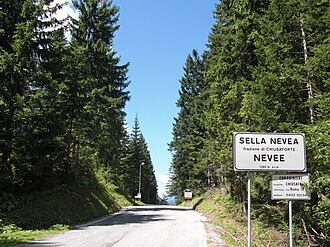
Nevea saddle
| Nevea saddle | |||
|---|---|---|---|
|
Pass height |
|||
| Compass direction | west | east | |
| Pass height | 1195 m slm | ||
| province | Udine | ||
| Watershed | Raccolana → Fella → Tagliamento → Adria | Slizza / Gailitz → Gail → Drau → Danube → Black Sea | |
| Valley locations | Chiusaforte | Tarvisio | |
| expansion | Strada Provinciale 76 | ||
| Mountains | Julian Alps | ||
| map | |||
|
|
|||
| Coordinates | 46 ° 23 '26 " N , 13 ° 28' 32" E | ||
The Sella Nevea , Italian Sella Nevea , comune Nevee , Slovenian Na Žlebeh , is a 1195 m slm high transition in the western Julian Alps between the Montaschkette and the Kaninstock .
Well-developed asphalt roads lead from Tarvisio in the Canal Valley via Raibl (Cave del Predil) and the Raibler See as well as from Chiusaforte - Raccolana , also in the Canal Valley, through the Raccolana Valley to the Nevea Saddle. The top of the pass is in the municipality of Chiusaforte.
Julius Kugy , the well-known developer of the Julian Alps, described the Nevea saddle as a “forest paradise” in the late 19th century.
After the loss of Venice in 1859 , the border between Austria and Italy ran through the Montasch group from the Sondogne (Köpfach) to the Cregnedul ( 2327 m slm ) and across the Cima Confine a little northeast of the Cergnala (Hudi Vršič, 2344 m slm ), and beyond Bovec (Flitsch / Plezzo) on the Isonzo (Soča) and the Krn . In the mountain war of the First World War , the Austro-Italian front also ran here: the Italians fortified the Neveapass, opposite the Raibler Seefort . Since the Italian military leadership saw it as a primary goal to isolate the city of Trieste from the start of the war in 1915 , they bit into the southern flank of the Alpine front in the multi-year series of Isonzo battles , here it remained comparatively quiet: the direct passage through the Canal Valley was not an option. Only after the " Miracle of Good Freit " (Kobarid, 12th Isonzo Battle), the surprising march through the Austrians and Germans at the end of October 1917, the Nevea saddle was overrun in a short time, at the end of the war after the battle of Vittorio Veneto in autumn 1918 in general Dissolution of the Austro-Hungarian Army but evacuated without a fight. With the Treaty of Rapallo 1920, Raibl also came to Italy. The municipal boundary to Tarvisio runs to this day about 3 km east of the saddle.
Today the Neveasattel has become a modern hotel city. It is a ski area in winter and the starting point for numerous mountain tours in the Montasch and Cimone ranges in summer. A cable car leads from the saddle to the Rifugio Celso Gilberti at 1850 m in the south and from there to the Prevala on Golovec ( 2285 m slm ), where there is a connection to the Bovec ski area ( Kanin –Sella Nevea – Bovec ski area ). The Kanin ( 2587 m slm ) rises southeast of the saddle. An asphalt road leads to the Pecolalm below the Montasio (Montasch, 2754 m slm ).
The area south of the Nevea is part of the Parco Naturale Prealpi Giulie (Julian Prealps Natural Park) . The saddle is considered as well as the northerly Cregnedulalm as a snake paradise (mainly adders ).
Individual evidence
-
↑ Kanin-Sella Nevea Ski Resort , boveckanin.si;
Sella Nevea - rabbit. , PhD, Agenzia Regionale Friuli Venezia Julia;
Kanin - Bovec - Sella Nevea ski area and Sella Nevea ski area. bergfex.at. - ↑ The Slovenian side has been out of service since a gondola crash in 2013 on the old Kanin cable car from the 1970s. Kanin zaprt, vzrok za nesrečo še priceiskujejo. ( Memento of the original from September 18, 2013 in the Internet Archive ) Info: The archive link was inserted automatically and has not yet been checked. Please check the original and archive link according to the instructions and then remove this notice. Delo.si/STA, January 26, 2013.

