
Rijksweg 2
| Autosnelweg A2 / Autoweg N2 in the Netherlands | |||||||||||||||||||||||||||||||||||||||||||||||||||||||||||||||||||||||||||||||||||||||||||||||||||||||||||||||||||||||||||||||||||||||||||||||||||||||||||||||||||||||||||||||||||||||||||||||||||||||||||||||||||||||||||||||||||||||||||||||||||||||||||||||||||||||||||||||||||||||||||||||||||||||||||||||||||||||||||||||||||||||||||||||||||||||||||||||||||||||||||||||||||||||||||||||||||||||||||||||||||||||||||||||||||||||||||||||||
 
|
|||||||||||||||||||||||||||||||||||||||||||||||||||||||||||||||||||||||||||||||||||||||||||||||||||||||||||||||||||||||||||||||||||||||||||||||||||||||||||||||||||||||||||||||||||||||||||||||||||||||||||||||||||||||||||||||||||||||||||||||||||||||||||||||||||||||||||||||||||||||||||||||||||||||||||||||||||||||||||||||||||||||||||||||||||||||||||||||||||||||||||||||||||||||||||||||||||||||||||||||||||||||||||||||||||||||||||||||||
| |
|||||||||||||||||||||||||||||||||||||||||||||||||||||||||||||||||||||||||||||||||||||||||||||||||||||||||||||||||||||||||||||||||||||||||||||||||||||||||||||||||||||||||||||||||||||||||||||||||||||||||||||||||||||||||||||||||||||||||||||||||||||||||||||||||||||||||||||||||||||||||||||||||||||||||||||||||||||||||||||||||||||||||||||||||||||||||||||||||||||||||||||||||||||||||||||||||||||||||||||||||||||||||||||||||||||||||||||||||
| map | |||||||||||||||||||||||||||||||||||||||||||||||||||||||||||||||||||||||||||||||||||||||||||||||||||||||||||||||||||||||||||||||||||||||||||||||||||||||||||||||||||||||||||||||||||||||||||||||||||||||||||||||||||||||||||||||||||||||||||||||||||||||||||||||||||||||||||||||||||||||||||||||||||||||||||||||||||||||||||||||||||||||||||||||||||||||||||||||||||||||||||||||||||||||||||||||||||||||||||||||||||||||||||||||||||||||||||||||||
 |
|||||||||||||||||||||||||||||||||||||||||||||||||||||||||||||||||||||||||||||||||||||||||||||||||||||||||||||||||||||||||||||||||||||||||||||||||||||||||||||||||||||||||||||||||||||||||||||||||||||||||||||||||||||||||||||||||||||||||||||||||||||||||||||||||||||||||||||||||||||||||||||||||||||||||||||||||||||||||||||||||||||||||||||||||||||||||||||||||||||||||||||||||||||||||||||||||||||||||||||||||||||||||||||||||||||||||||||||||
| Basic data | |||||||||||||||||||||||||||||||||||||||||||||||||||||||||||||||||||||||||||||||||||||||||||||||||||||||||||||||||||||||||||||||||||||||||||||||||||||||||||||||||||||||||||||||||||||||||||||||||||||||||||||||||||||||||||||||||||||||||||||||||||||||||||||||||||||||||||||||||||||||||||||||||||||||||||||||||||||||||||||||||||||||||||||||||||||||||||||||||||||||||||||||||||||||||||||||||||||||||||||||||||||||||||||||||||||||||||||||||
| Operator: |
|
||||||||||||||||||||||||||||||||||||||||||||||||||||||||||||||||||||||||||||||||||||||||||||||||||||||||||||||||||||||||||||||||||||||||||||||||||||||||||||||||||||||||||||||||||||||||||||||||||||||||||||||||||||||||||||||||||||||||||||||||||||||||||||||||||||||||||||||||||||||||||||||||||||||||||||||||||||||||||||||||||||||||||||||||||||||||||||||||||||||||||||||||||||||||||||||||||||||||||||||||||||||||||||||||||||||||||||||||
| Overall length: | 217 km | ||||||||||||||||||||||||||||||||||||||||||||||||||||||||||||||||||||||||||||||||||||||||||||||||||||||||||||||||||||||||||||||||||||||||||||||||||||||||||||||||||||||||||||||||||||||||||||||||||||||||||||||||||||||||||||||||||||||||||||||||||||||||||||||||||||||||||||||||||||||||||||||||||||||||||||||||||||||||||||||||||||||||||||||||||||||||||||||||||||||||||||||||||||||||||||||||||||||||||||||||||||||||||||||||||||||||||||||||
| Requirement for use: | Toll free | ||||||||||||||||||||||||||||||||||||||||||||||||||||||||||||||||||||||||||||||||||||||||||||||||||||||||||||||||||||||||||||||||||||||||||||||||||||||||||||||||||||||||||||||||||||||||||||||||||||||||||||||||||||||||||||||||||||||||||||||||||||||||||||||||||||||||||||||||||||||||||||||||||||||||||||||||||||||||||||||||||||||||||||||||||||||||||||||||||||||||||||||||||||||||||||||||||||||||||||||||||||||||||||||||||||||||||||||||
| Development condition: | 2 × 2, 2 × 3, 2 × 4, 2 × 5 lanes + emergency lanes, | ||||||||||||||||||||||||||||||||||||||||||||||||||||||||||||||||||||||||||||||||||||||||||||||||||||||||||||||||||||||||||||||||||||||||||||||||||||||||||||||||||||||||||||||||||||||||||||||||||||||||||||||||||||||||||||||||||||||||||||||||||||||||||||||||||||||||||||||||||||||||||||||||||||||||||||||||||||||||||||||||||||||||||||||||||||||||||||||||||||||||||||||||||||||||||||||||||||||||||||||||||||||||||||||||||||||||||||||||
|
Course of the road
|
|||||||||||||||||||||||||||||||||||||||||||||||||||||||||||||||||||||||||||||||||||||||||||||||||||||||||||||||||||||||||||||||||||||||||||||||||||||||||||||||||||||||||||||||||||||||||||||||||||||||||||||||||||||||||||||||||||||||||||||||||||||||||||||||||||||||||||||||||||||||||||||||||||||||||||||||||||||||||||||||||||||||||||||||||||||||||||||||||||||||||||||||||||||||||||||||||||||||||||||||||||||||||||||||||||||||||||||||||
The A2 is a Rijksweg and a Dutch motorway . The motorway begins in Amsterdam at the Amstel junction and runs via Utrecht , 's-Hertogenbosch , Eindhoven and Maastricht to the Belgian border near Eijsden . From there, the route continues as the A25 to Liège in Wallonia .
The A2 is considered to be the most important north-south connection in the Netherlands, especially the section from Amsterdam to Eindhoven has an immensely high volume of traffic.
course
The A2 has a length of 217 km. Between Amsterdam and Utrecht, the A2 follows the route of the E 35 , then the route of the E 25 .
In some parts, other motorways run along one route together with the A2:
- the A59 between the Empel and Hintham junctions
- the A67 between the De Hogt and Leenderheide junctions
history
The section between Amsterdam and Utrecht was opened in 1954 and is mistakenly often referred to as the first Dutch motorway. The first Dutch motorway section was opened in 1936 between Voorburg and Zoetermeer as part of today's A12 . Large parts of today's A4 , A12 and A44 motorways were already completed before the outbreak of World War II . The section opened in 1954, on the other hand, was the first section of the motorway to be opened after the Second World War with separate lanes.
On January 10, 2005, the Ministry of Transport began a trial of the “dynamic overtaking ban” (no overtaking for trucks during rush hour) on the A2 between Abcoude and Maarssen . At Maastricht, the A2 was a N2 car route for a few kilometers. The N2 continued through Maastricht. There were regular traffic jams and high levels of air pollution. The King Willem Alexander tunnel under the city provides a remedy today.
Dropped plans
In the 1960s, an alternative route for the motorway between 's-Hertogenbosch and Weert was planned, which should run east past Eindhoven through the Strabrechtse Heide . However, this planning was no longer pursued after 1971. The expansion of the existing western bypass of Eindhoven is still regarded as a temporary measure.
Future developments
The A2 has been a bottleneck and a source of congestion for years. The Amsterdam - Utrecht (CAU) corridor study led to a cabinet decision in the mid-1990s to extend the motorway. What was special about this study was that the increase in capacity of the motorway was also considered in connection with the transport capacities of the other traffic routes, in this case rail and waterways . The expansion work on the motorway should be completed according to plan in 2012.
On January 5, 2007 it was announced that the traffic between Breukelen and Maarssen in the direction of Utrecht and at the Everdingen junction south of Utrecht will be monitored by cameras in order to send questionnaires to particularly strong users of the A2. On these, they were asked to state whether they would be willing to use alternative means of transport (e.g. local public transport) during the construction work. The installed cameras were dismantled again in mid-March 2007.
Near Utrecht
After the expansion, the motorway in the Utrecht area will each have five directional lanes, three of which will be continuous and two more will be built as parallel lanes to separate local traffic from long-distance traffic. Over a length of 1650 meters, the motorway is run in the tunnel in order to be able to build a new district ( Leidsche Rijn ) with an estimated 80,000 inhabitants above it. During the construction of this district, temporary junctions will be built in order to keep construction site traffic as far as possible from the city streets. The A2 will then be expanded to four directional lanes between the Maarssen junction and the Holendrecht junction and then to five lanes each to the Abcoude junction.
On May 10, 2006, Minister of Transport Karla Peijs announced the ten-lane expansion between the Holendrecht and Oudenrijn junctions . The first lanes were opened to traffic on July 16, 2010, and the second section between Vinkeveen and Utrecht was opened on July 21, 2010.
As the development of traffic in the middle of the Netherlands continues with the expansion of the infrastructure, a new study was commissioned in 2006 to develop further measures.
Everdingen - 's-Hertogenbosch
In February 2006, construction work began with the extension of the A2 to three lanes each between the Everdingen and Culemborg junction. At Rosmalen and 's-Hertogenbosch, the motorway is being expanded to four lanes each, with two lanes for local and two lanes for long-distance traffic in each direction. The municipality of 's-Hertogenbosch is planning to relocate a new residential and business district on the motorway as part of the A2 expansion. In the course of this planning, the A2 is being led through a tunnel north of the Hintham junction over a length of 300 meters.
's-Hertogenbosch - Eindhoven
At the end of 2011, the six-lane expansion of this 20 km long section began. October 2013 the section Vught-Knp. Ekkersweijer opened in six lanes.
Near Eindhoven
As part of a fundamental repair of the (incomplete) motorway ring, the motorway was expanded to four times two directional lanes. There is also a separation between local and long-distance traffic. Long-distance traffic is subject to a speed limit of 120 km / h, local traffic on the parallel lanes of 80 km / h. Despite these measures, this section is extremely congested. The A73 , which was completed in 2008, will also relieve the A2 and the Eindhoven conurbation.
At Maastricht
In January 2006, the parties involved signed the financing plan for the König-Willem-Alexander-Tunnel , an eight-lane tunnel under Maastricht (including distribution lanes) through the A2. The agreement stipulated a construction period from 2007 to 2012. The tunnel construction began in 2012 and was completed in 2016.
Bridge structures
As part of the expansion of the A2, a number of bridges will also be renovated or newly built:
- new Utrecht bridge over the Amstel in Amsterdam
- Jan Blanken Bridge over the Lek near Vianen
- Martinus Nijhoff Bridge over the Waal near Zaltbommel
- Maas bridge near Empel
- Green bridge between Boxtel and Best
- Maas bridge between Wessem and Maastricht
Others
- A computer game called A2 Racers has been released in the Netherlands about the A2 .
- The motorway was flooded by the Dommel in January 1995 at the Vught junction near 's-Hertogenbosch .
photos
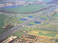
Oudenrijn junction near Utrecht

Jan Blankenbrug and old Lekbrücke

A2 at 's-Hertogenbosch

Expansion of the A2 in Culemborg (2007)
Expansion of the A2 in Diefdijk (2007)

A 2 at Vught (afrit 24)

Flooded A 2

Kreuz Leenderheide (old situation, until around 2009)
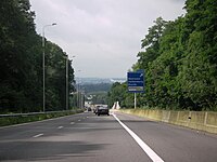
A2 near Meerssen (afrit 51)

Former route of the N2 in Maastricht

Construction site of the A2 tunnel (2013)

A2 near Gronsveld (afrit 56)

.jpg)


_-_Exit_51.JPG)


Web links
- Projects of the Ministry of Transport on the A2 in North Brabant (Dutch)
- Development of the Dutch motorways before 1954 (Dutch)
| Current routes |
A1 | A2 / N2 | N3 | A4 | A5 | A6 | A7 / N7 | A8 / N8 | A9 / N9 | A10 | N11 | A12 | A13 | N14 | A15 / N15 | A16 | A17 | A18 / N18 | A20 | A22 | A27 | A28 | A29 | A30 | A31 / N31 | A32 / N32 | N33 | A35 / N35 | N36 | A37 | A38 | A44 / N44 | N46 | N48 | A50 / N50 | N57 | A58 / N58 | A59 / N59 | N61 | A65 / N65 | A67 | A73 | A74 | A76 | A77 | A79 | N99 | A200 / N200 |
 |
| Former routes |
N34 | N41 | N46 | A48 / N48 | A52 / N52 | N60 | A68 / N68 | N69 | N265 | N271 | N289 |