Březina military training area
| Březina | ||||
|---|---|---|---|---|
|
||||
| Basic data | ||||
| State : |
|
|||
| Region : | Jihomoravský kraj | |||
| District : | Vyškov | |||
| Area : | 14962 ha | |||
| Geographic location : | 49 ° 22 ' N , 16 ° 58' E | |||
| Height: | 360 m nm | |||
| Residents : | 0 (Jan. 1, 2019) | |||
| Postal code : | 682 03 | |||
| structure | ||||
| Status: | Military area | |||
| Districts: | 1 | |||
| administration | ||||
| Head of Office : | Karel Schimitzek (as of 2010) | |||
| Address: | Víta Nejedlého 682 03 Vyškov |
|||
| Municipality number: | 592935 | |||
| Website : | www.vojujezd-brezina.cz | |||
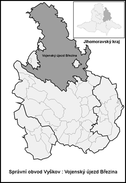
| Location of Březina in the Vyškov district | ||||

|
||||
The military training area Březina (Czech Vojenský újezd Březina , also VVP Dědice ) is a special, directly belonging to the Czech state area with 9 inhabitants (January 1, 2005) in the Czech Republic . It is located between Brno and Olomouc in Okres Vyškov west of the cities Vyškov and Prostějov in Drahanská country (Drahanská vrchovina) and had irsprünglich an area of 158.17 square kilometers. The military training area is located in Vyškov.
history
In 1935 the Czechoslovak Army set up a military training area, the so-called Vojensky výcvikový prostor na Drahanské vrchovině . In 1940, Reich Protector Konstantin von Neurath ordered the establishment of the Wischau military training area for the German armed forces in the Protectorate of Bohemia and Moravia . The city of Wischau and its surrounding area belonged to the German-speaking Wischau language island . A military training area was set up north of the city, for this purpose a total of 33 Czech-speaking villages were evacuated in five stages between 1941 and 1945.
The Czechoslovak military training ground on May 1, 1951. parts of the corridors of the 22 villages Bousín , Dolní Otaslavice, Drahany , Hamry, Horní Otaslavice, Kobylničky, Krásensko , Křenůvky, Malé Hradisko, Myslejovice, Nové Sady , Plumlov , Podivice , Prostějovičky, Radslavice , Radslavičky, Repechy , Rychtářov , Stínava, Studnice , Vícov and Žárovice.
On January 1, 2015, the Březina military training area was reduced in size. The following cadastral districts were spun off:
- Cihelny u Podivic to the municipality of Podivice ,
- Chaloupky u Otaslavic to the municipality of Otaslavice ,
- Občiny u Drahan to the Drahany municipality ,
- Osinky u Krumsína to the municipality of Krumsín ,
- Ostatky u Křenůvek to the Myslejovice municipality
- Žleb u Prostějoviček to the Prostějovičky municipality .
structure
The area of the military training area is determined by the boundaries of the cadastral districts of Doubrava u Březiny , Kotáry , Osina , Pulkava , Stříbrná u Březiny and Žbánov . Basic settlement units are Březina, Doubrava, Kotáry, Osina, Pulkava, Stříbrná and Žbánov.
Attractions
- Baroque hunting lodge Ferdinandsko , built 1755–1757
Individual evidence
- ↑ http://www.uir.cz/obec/592935/Brezina
- ↑ Český statistický úřad - The population of the Czech municipalities as of January 1, 2019 (PDF; 7.4 MiB)
- ↑ Jan Celý: Vysídlení Drahanské vrchoviny za války
- ↑ a b Zákon o zrušení vojenského újezdu Brdy, o stanovení hranic vojenských újezdů, o změně hranic krajů ao změně souvisejících zákonů (zákon o hranicích vojezdů)
- ↑ http://www.uir.cz/katastralni-uzemi-obec/555177/Obec-Hradiste
- ↑ http://www.uir.cz/zsj-obec/592935/Obec-Brezina


