
Wayne County (Illinois)
 Wayne County Courthouse |
|
| administration | |
|---|---|
| US state : | Illinois |
| Administrative headquarters : | Fairfield |
| Address of the administrative headquarters: |
Wayne County Courthouse 301 E. Main Street P. O. Box 96 Fairfield, IL 62837 |
| Foundation : | March 26, 1819 |
| Made up from: | Edwards County |
| Area code : | 001 618 |
| Demographics | |
| Residents : | 16,760 (2010) |
| Population density : | 9.2 inhabitants / km 2 |
| geography | |
| Total area : | 1835 km² |
| Water surface : | 4 km² |
| map | |
 |
|
The Wayne County is a county in the US -amerikanischen State Illinois . In 2010 , the county had 16,760 people and a population density of 9.2 people per square kilometer. The county seat is Fairfield .
geography
The county is located in southeast Illinois. It has an area of 1835 km², of which 4 km² are water. The following neighboring counties border Wayne County:
| Marion County | Clay County | Richland County |
.svg)
|
Edwards County | |
| Jefferson County | Hamilton County | White County |
history

| Population development | |||
|---|---|---|---|
| Census | Residents | ± in% | |
| 1820 | 1114 | - | |
| 1830 | 2553 | 129.2% | |
| 1840 | 5133 | 101.1% | |
| 1850 | 6825 | 33% | |
| 1860 | 12,223 | 79.1% | |
| 1870 | 19,758 | 61.6% | |
| 1880 | 21,291 | 7.8% | |
| 1890 | 23,806 | 11.8% | |
| 1900 | 27,626 | 16% | |
| 1910 | 25,697 | -7% | |
| 1920 | 22,772 | -11.4% | |
| 1930 | 19,130 | -16% | |
| 1940 | 22.092 | 15.5% | |
| 1950 | 20,933 | -5.2% | |
| 1960 | 19.008 | -9.2% | |
| 1970 | 17.004 | -10.5% | |
| 1980 | 18,059 | 6.2% | |
| 1990 | 17,241 | -4.5% | |
| 2000 | 17,151 | -0.5% | |
| 2010 | 16,760 | -2.3% | |
| Before 1900 1900–1990 2000 2010 | |||
Wayne County was formed on March 26, 1819 from Edwards County. It was named after Anthony Wayne (1745–1796), a Pennsylvania politician , general during the Revolutionary and in the Northwest Territory.
On November 17, 1886, most of the courthouse was destroyed by fire, as was most of the documents stored there. The courthouse, which is still in use today, was completed in 1981.
Territorial development
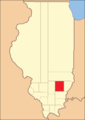
Wayne County between its founding in 1819 and 1821

1821 to 1824

1824 until today


Demographic data
According to the 2010 census , Wayne County had 16,760 people in 7241 households. The population density was 9.2 inhabitants per square kilometer. Statistically, 2.3 people lived in each of the 7241 households.
The racial the population was composed of 98.0 percent white, 0.5 percent African American, 0.2 percent Native American, 0.5 percent Asian and other ethnic groups; 0.7 percent were descended from two or more races. Hispanic or Latino of any race was 1.1 percent of the population.
22.6 percent of the population were under 18 years old, 57.8 percent were between 18 and 64 and 19.6 percent were 65 years or older. 50.7 percent of the population was female.
The median income for a household was 40,654 USD . The per capita income was $ 22,319. 13.6 percent of the population lived below the poverty line.
Wayne County localities
1 - partly in White County
2 - partly in Edwards County
3 - partly in Richland County
structure
Wayne County is divided into 20 townships :
|
|
See also
Individual evidence
- ↑ GNIS-ID: 424296. Retrieved on February 22, 2011 (English).
- ↑ a b c U.S. Census Bureau, State & County QuickFacts - Wayne County, IL Retrieved January 18, 2013
- ↑ a b National Association of Counties.Retrieved January 18, 2013
- ^ US Census Bureau - Census of Population and Housing.Retrieved March 15, 2011
- ^ Extract from Census.gov.Retrieved February 15, 2011
- ↑ Missouri Census Data Center - Illinois ( page no longer available , search in web archives ) Info: The link was automatically marked as defective. Please check the link according to the instructions and then remove this notice. Retrieved January 18, 2013
Web links
List of counties in Illinois
Adams |
Alexander |
Bond |
Boone |
Brown |
Bureau |
Calhoun |
Carroll |
Cass |
Champaign |
Christian |
Clark |
Clay |
Clinton |
Coles |
Cook |
Crawford |
Cumberland |
DeKalb |
DeWitt |
Douglas |
DuPage |
Edgar |
Edwards |
Effingham |
Fayette |
Ford |
Franklin |
Fulton |
Gallatin |
Greene |
Grundy |
Hamilton |
Hancock |
Hardin |
Henderson |
Henry |
Iroquois |
Jackson |
Jasper |
Jefferson |
Jersey |
Jo Daviess |
Johnson |
Kane |
Kankakee |
Kendall |
Knox |
LaSalle |
Lake |
Lawrence |
Lee |
Livingston |
Logan |
Macon |
Macoupin |
Madison |
Marion |
Marshall |
Mason |
Massac |
McDonough |
McHenry |
McLean |
Menard |
Mercer |
Monroe |
Montgomery |
Morgan |
Moultrie |
Ogle |
Peoria |
Perry |
Piatt |
Pike |
Pope |
Pulaski |
Putnam |
Randolph |
Richland |
Rock Island |
Saline |
Sangamon |
Schuyler |
Scott |
Shelby |
St. Clair |
Strong |
Stephenson |
Tazewell |
Union |
Vermilion |
Wabash |
Warren |
Washington |
Wayne |
White |
Whiteside |
Will |
Williamson |
Winnebago |
Woodford
Coordinates: 38 ° 26 ′ N , 88 ° 25 ′ W