
Briord
| Briord | ||
|---|---|---|
|
||
| region | Auvergne-Rhône-Alpes | |
| Department | Ain | |
| Arrondissement | Belley | |
| Canton | Lagnieu | |
| Community association | Plaine de l'Ain | |
| Coordinates | 45 ° 47 ' N , 5 ° 28' E | |
| height | 200-580 m | |
| surface | 12.3 km 2 | |
| Residents | 1,016 (January 1, 2017) | |
| Population density | 83 inhabitants / km 2 | |
| Post Code | 01470 | |
| INSEE code | 01064 | |

Briord is a French commune in the Ain department in the region of Auvergne Rhône-Alpes . In the south-west, the Rhône forms the border with the Isère department . Opposite are the municipalities of Bouvesse-Quirieu and Creys-Mépieu . The neighboring communities in the Ain department are Montagnieu in the northwest, Seillonnaz in the northeast, Marchamp in the east and Lhuis in the southeast.
history
The Latin name was "Brioratis". The settlement was then in Gaul . See also list of ancient place names and geographical names / Br .
Attractions
The aqueduct at Briord is of Roman origin and classified as a monument historique . The Saint-André castle is also registered as a monument historique.
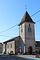
Saint-Jean-Baptiste church

Population development
| year | 1962 | 1968 | 1975 | 1982 | 1990 | 1999 | 2008 | 2014 |
|---|---|---|---|---|---|---|---|---|
| Residents | 366 | 393 | 413 | 520 | 618 | 675 | 856 | 973 |
economy
- Ligne Roset , furniture manufacturer, operates as Roset SA
Web links
Commons : Briord - collection of images, videos and audio files