Dobřany
| Dobřany | ||||
|---|---|---|---|---|
|
||||
| Basic data | ||||
| State : |
|
|||
| Region : | Plzeňský kraj | |||
| District : | Plzeň-jih | |||
| Area : | 3531 ha | |||
| Geographic location : | 49 ° 39 ' N , 13 ° 17' E | |||
| Height: | 352 m nm | |||
| Residents : | 6,154 (Jan 1, 2019) | |||
| Postal code : | 334 41 | |||
| traffic | ||||
| Railway connection: | Plzeň – Železná Ruda | |||
| structure | ||||
| Status: | city | |||
| Districts: | 3 | |||
| administration | ||||
| Mayor : | Martin Sobotka (as of 2014) | |||
| Address: | nám. TG Masaryka 1 334 41 Dobřany |
|||
| Municipality number: | 557676 | |||
| Website : | www.dobrany.cz | |||
Dobřany (German Dobrzan , 1939-1945: Wiesengrund ) is a town with 5887 inhabitants in the Okres Plzeň-jih in the Czech Republic .
geography
The city is located in western Bohemia at 352 m above sea level. M. in the valley of the river Radbuza ( Radbusa ), on its right bank at the confluence of the Chlumčanský potok, 13 km southwest of the city center of Pilsen . The cadastral area is 3531 hectares.
The D 5 motorway runs three kilometers to the northeast , which is also part of the European route 50 here . In the east, also three kilometers away, the route of the European route 53 / state route 27 runs from Pilsen to Přeštice . The railway line from Pilsen to Klatovy runs through the town . To the north of the Vodní Újezd district is the former military airfield, today the closed international airfield Pilsen-Líně .
Neighboring towns are Nová Ves and Lhota in the north, Chlumčany in the south and Bayerův Důl, Vstiš and Vodní Újezd in the west. To the south-west of it lies the extensive complex of the psychiatric clinic, behind it Černotín .
history
Dobřany was first mentioned in 1243 as the property of Záviš z Dobřan from the family of the Markwartinger . In 1259 Dobřany was already a town that had two churches, the Church of St. Vitus and St. Nicholas, and together with the village of Tymákov belonged to Jan z Dobřan. The town then passed to the Cresbo family, who sold it to the Chotěšov monastery in 1270 . In 1282, the Chotieschauer monastery also acquired the Magdalen monastery in Dobřany from their prioress Jutta von Au. The St. Nicholas Church appears as a parish church as early as 1431.
In 1378 the town was granted privileges by Provost Ulrich and the town order of the Pilsener was adapted. In 1585, Emperor Rudolf II granted Dobřany the right to levy a road and bridge toll and got back the brewing rights that had been lost in the Hussite Wars.
After the decree of the Renewed Land Order of 1627, which made German and Czech an official language, many of the Germans who moved there no longer learned Czech and the town became partially German-speaking. In 1637, the butchers became the first trade in the city to join a guild .
In 1652 the town hall, which was destroyed in the city fire in the Thirty Years War, and the St. Nicholas Church were rebuilt. In the berní rula there are 92 inhabited and 22 desolate houses for the city. In 1677, 973 people lived in Dobřany. On April 27, 1680, the troops of General Christoph Wilhelm Harant von Polschitz marched through the city on the way to suppress peasant uprisings in the Tepler Land.
In 1727 the demolition of the St. Vitus Church began, which was replaced by a new baroque building consecrated in 1734. Between 1756 and 1758 the St. Nicholas Church was redesigned in baroque style and expanded in the process. As can be seen from a chronogram in the St. Vitus Church, a hostile invasion took place in 1743. After the dissolution of the Chotieschau monastery in the course of the Josephine reforms of 1782, its property was sold and the secular rule of Chotieschau emerged from the monastery rule . From this, the last provost of the monastery bought a house on Dobřany's market square, where he lived until his death in 1797. In 1794 the dragon regiment stationed in the city barracks built the stone bridge over the Radbusa. In 1801 the city was ravaged by a fire. In 1822 Karl Alexander von Thurn und Taxis acquired the rule of Chotieschau.
After the repeal of the subservience decided by the Reichstag on September 7, 1848 , the patrimonial rule was dissolved and Dobrzan became part of the political district of Staab . During the reform of the political districts and the judicial districts of 1862, the city was assigned to the district administration Mies . In 1873 the new brewery built by Franz Schultes went into operation and on September 20, 1876 the first train from Pilsen to Klattau drove through the city.
Between 1876 and 1883, the state insane asylum (today Dobřany Psychiatric Hospital ) was built southwest of the town across the Klumchan brook , and the first building was opened on April 13, 1880. In 1880 the Church of the Exaltation of the Cross was consecrated in the institution. A new barracks was built for the Dragoon Regiment from 1888 to 1889.
In 1900 Dobrzan had 5,183 inhabitants, of which 3,005 were German (58%) and 2,155 Czech (42%). The state insane asylum accommodated 1,500 patients.
Between 1900 and 1902 the town hall was rebuilt in place of the previous building from 1652. In 1902 Dobrzan became the seat of a district court and tax office. There was a beer brewery on site .
After the First World War , the place was added to the newly created Czechoslovakia in 1919 . Due to the Munich Agreement , the place came to the German Reich in 1938 and until 1945 belonged to the district of Mies , administrative district of Eger , in the Reichsgau Sudetenland . Because of its importance as the seat of a district court, Dobrzan was one of the few places in the Sudetenland that was given a new name. On December 19, 1939, the place name Dobrzan, which is of Slavic origin, was replaced by the new place name Wiesengrund .
During the Nazi period, children and young people with mental disabilities were murdered in the children's department of the psychiatric institution in Wiesengrund. On the night of April 16-17, 1943, British bombers mistakenly dropped bombs on meadow during an attack on Pilsen . On May 6, 1945, troops of the 3rd US Army occupied the city.
After the end of the war, the approx. 2000 German residents were expelled to the western occupation zones, which was completed on April 16, 1946. The property of the Princely House of Thurn and Taxis was nationalized. The music school was established in 1946. From 1948 the nationalization of the remaining private companies began.
During the territorial reform of January 1, 1949, the town was reclassified from Okres Stříbro to Okres Přeštice and the Dobřany District Court was repealed. From 1950 the collectivization of agriculture began. After the proclamation of the ČSSR in 1960, the Okres Plzeň-jih was established in the same year as part of a renewed territorial reform . The municipality of Vodní Újezd was also incorporated in 1960.
In the 1960s, the new cycle bus bridge for the state road to Chotěšov was built . In 1992 the historic city center was declared a monument zone. The town hall, which was renovated between 1994 and 1999, has been listed as a cultural monument since 1995 . In 1995 Dobřany was given the right to use a city flag. In 1999, the Radbuza microregion was created, the seat of which is Dobřany.
Demographics
Until 1945 Wiesengrund had a large part of the population of German Bohemia , which were expelled.
| year | Residents | Remarks |
|---|---|---|
| 1785 | k. A. | 222 houses including suburbs |
| 1830 | 1800 | in 276 houses |
| 1835 | 1835 | in 274 houses |
| 1900 | 5183 | mostly German residents |
| 1921 | 5091 | including 2334 German residents |
| 1930 | 6429 | |
| 1939 | 5460 |
| year | 1970 | 1980 | 1991 | 2001 | 2003 |
|---|---|---|---|---|---|
| Residents | 4,969 | 5 171 | 5 624 | 5 666 | 5 779 |
Attractions

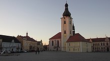
- St. Veitskirche, Baroque building from 1727 to 1734 by Jakob Auguston the Elder . J. erected, the double altar was carved by Mathias Wenzel Jäckel . The eleven meter high bell tower with a cross on the roof dates back to 1865, the structure was restored between 1995 and 1999
- St. Nicholas Church, rebuilt in the Baroque style from 1756–1758
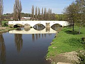
- Bridge over the Radbuza , stone late Gothic building with three arches and a length of 50 m
- Rectory
- Church of the Exaltation of the Cross in the psychiatric clinic, built in 1880 in the neo-Renaissance style
City structure
The districts Šlovice ( Schlowitz ) and Vodní Újezd ( Wasseraujezd ) as well as the location Dobřánky belong to Dobřany.
Town twinning
Dobřany maintains partnerships with the Slovenian city of Brežice (Rann) and with the Bavarian city of Obertraubling .
Personalities
sons and daughters of the town
- Johann Joseph Ignaz Brentner (1689–1742), composer
- Joseph Maria Wolfram (1789–1839), composer
- Josef Langl (1843–1916), Austrian painter and graphic artist
- Franz Andreß (* 1870; † after 1926), teacher and local researcher
- Franz Hruska (1888–1977), German politician
- Karl Petrus Möhler (1897–1968), abbot of the Teplá Monastery
- Ota Koval (1931–1991), Czechoslovak film director
Web links
- City website (cz)
Individual evidence
- ↑ Český statistický úřad - The population of the Czech municipalities as of January 1, 2019 (PDF; 7.4 MiB)
- ↑ a b Jaroslaus Schaller : Topography of the Kingdom of Bohemia. Volume 9: Pilsner Kreis. Prague 1788, p. 108, paragraph 27) .
- ↑ a b c Johann Gottfried Sommer : The Kingdom of Bohemia . Volume 6: Pilsner Kreis. Prague 1838, pp. 110–112, paragraph 6 .
- ↑ a b c Dobrzan . In: Meyers Großes Konversations-Lexikon . 6th edition. Volume 5, Bibliographisches Institut, Leipzig / Vienna 1906, p. 74 .
- ↑ Press release on the exhibition: Unworthy of life - the National Socialist 'Euthanasia' in the Reichsgau Sudetenland and the Protectorate of Bohemia and Moravia 1939 - 1945 , PDF, October 20, 2012, accessed September 29, 2015.
- ^ Carl Eduard Rainold: Reise-Taschen-Lexikon für Böhmen . Prague 1835, p. 119 .
- ^ Sudetenland Genealogy Network
- ^ A b Michael Rademacher: German administrative history from the unification of the empire in 1871 to reunification in 1990. Mies district (Czech Stríbro). (Online material for the dissertation, Osnabrück 2006).
- ↑ Czech population statistics


