
Guénange
| Guénange | ||
|---|---|---|

|
|
|
| region | Grand Est | |
| Department | Moselle | |
| Arrondissement | Thionville | |
| Canton | Metzervisse | |
| Community association | Arc Mosellan | |
| Coordinates | 49 ° 18 ′ N , 6 ° 12 ′ E | |
| height | 153-233 m | |
| surface | 8.35 km 2 | |
| Residents | 7,210 (January 1, 2017) | |
| Population density | 863 inhabitants / km 2 | |
| Post Code | 57310 | |
| INSEE code | 57269 | |
| Website | Guénange | |
 Guénange Town Hall |
||

Guénange ( German Niederginingen , 1940-44 Niederganingen , Lorraine Genéngen ) is a French commune with 7210 inhabitants (as of January 1, 2017) in the Moselle department in the Grand Est region (until 2015 Lorraine ).
geography
The municipality of Guénange is located on the right bank of the Moselle , about seven kilometers south of Thionville . Basse-Guénange ( Niederginingen ) is located directly on the Moselle, Haute-Guénange ( Oberginingen ) inland.
history
The place was first mentioned in the 6th century as Ganigas and has belonged to France since 1659.
The village of Guélange ( Gelingen ) has been incorporated into the municipality since 1810 .
After the end of the Second World War , the steel boom gave the community a rapid upswing and its population multiplied.
Population development
| year | 1962 | 1968 | 1975 | 1982 | 1990 | 1999 | 2007 |
| Residents | 8,350 | 9,862 | 9,397 | 8,327 | 6,794 | 7.124 | 6,938 |
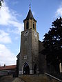
Saint-Matthieu church

Cemetery chapel
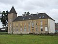
Guénange Castle


Web links