Route national 84a
| Route nationale 84 A in France | |
| N 84 A | |
| Basic data | |
| Operator: | |
| Overall length: | 0.5 km |
|
Regions : |
|
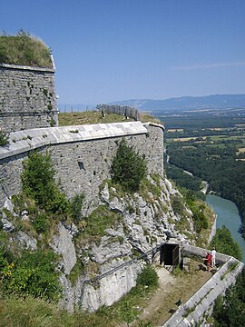
| View of part of the Fort l'Ecluse - The N84 A is in the background hidden by the fort | |
The N84 A was a French national road that was built in 1890 as a connection between the N84 and N206 at the Défilé de l'Écluse . Their length was only 500 meters. In 1933 it was renumbered N206 A. It is located at a narrow point of the Rhone , where the Fort de l'Écluse , which consists of two parts ( Fort d'en Haut and Fort d'en Bas ), was built. Furthermore, the railway line from Lyon to Geneva runs through the bottleneck and runs through a tunnel at the level of the road. From the railway line branches off to the west of the narrow point to Le Bouveret, which also passes the narrow point on the other bank of the Rhone. The junction with the N84 is at an acute angle, so that the intersection has the function of a junction. In 1978 the road became part of the N206 and in 2006 the road was graded. In 1933 a new N84 A was set as a branch of the N84. This can be found in the article of Route nationale 84 .
Web links
- Route nationale française on WikiSara, a list of all national roads (French)
