
Saint-Benoist-sur-Vanne
| Saint-Benoist-sur-Vanne | ||
|---|---|---|
|
||
| region | Grand Est | |
| Department | Aube | |
| Arrondissement | Troyes | |
| Canton | Aix-en-Othe | |
| Community association | Pays d'Othe | |
| Coordinates | 48 ° 16 ' N , 3 ° 39' E | |
| height | 143-263 m | |
| surface | 16.68 km 2 | |
| Residents | 237 (January 1, 2017) | |
| Population density | 14 inhabitants / km 2 | |
| Post Code | 10160 | |
| INSEE code | 10335 | |
| Website | http://saintbenoistsurvanne.jimdo.com/ | |

Saint-Benoist-sur-Vanne is a French commune with 237 inhabitants (as of January 1, 2017) in the Aube department in the Grand Est region (before 2016 Champagne-Ardenne ). It belongs to the canton of Aix-en-Othe in the Arrondissement of Troyes .
geography
Saint-Benoist-sur-Vanne is about 30 kilometers west-southwest of Troyes . Neighboring communities are Planty in the north, Paisy-Cosdon in the east and south-east, Rigny-le-Ferron in the south and south-west and Vulaines in the west.
Population development
| year | 1962 | 1968 | 1975 | 1982 | 1990 | 1999 | 2006 | 2011 | 2016 |
|---|---|---|---|---|---|---|---|---|---|
| Residents | 236 | 244 | 235 | 230 | 198 | 214 | 239 | 231 | 235 |
| Source: Cassini and INSEE | |||||||||
Attractions
- Saint-Benoit Church
- Chapel of Saint-Gengould in Courmononcle from the 12th century, monument historique since 1983
- Castle, monument historique since 1984
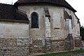
Saint-Benoit Church

Saint-Gengould chapel

lock

.jpg)

Web links
Commons : Saint-Benoist-sur-Vanne - Collection of images, videos and audio files