
Saint-Benoît-sur-Seine
| Saint-Benoît-sur-Seine | ||
|---|---|---|
|
||
| region | Grand Est | |
| Department | Aube | |
| Arrondissement | Troyes | |
| Canton | Creney-près-Troyes | |
| Community association | Troyes Champagne Métropole | |
| Coordinates | 48 ° 22 ′ N , 4 ° 2 ′ E | |
| height | 93-227 m | |
| surface | 11.78 km 2 | |
| Residents | 400 (January 1, 2017) | |
| Population density | 34 inhabitants / km 2 | |
| Post Code | 10180 | |
| INSEE code | 10336 | |

Saint-Benoît-sur-Seine is a French commune with 400 inhabitants (as of January 1, 2017) in the Aube department in the Grand Est region ; it belongs to the arrondissement of Troyes and the canton of Creney-près-Troyes (until 2015: canton of Troyes-2 ).
geography
Saint-Benoît-sur-Seine is located about eight kilometers north-north-west of Troyes city center on the Seine and the Melda . Saint-Benoît-sur-Seine is surrounded by the neighboring communities of Mergey in the north and north-west, Feuges in the east and north-east, Sainte-Maure in the south and south-east and Saint-Lyé in the west and south-west.
Population development
| year | 1962 | 1968 | 1975 | 1982 | 1990 | 1999 | 2006 | 2013 |
| Residents | 273 | 239 | 240 | 292 | 328 | 401 | 401 | 410 |
| Source: Cassini and INSEE | ||||||||
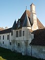
Attractions
- Church of Sainte-Maure
- Sainte-Maure Castle
- Vermoise Castle

Sainte-Maure Castle
Vermoise Castle
.JPG)
.jpg)
Personalities
- Rémi Delatte (* 1956), farmer and politician (UMP)
Web links
Commons : Saint-Benoît-sur-Seine - Collection of images, videos and audio files