
Trouans
| Trouans | ||
|---|---|---|
|
||
| region | Grand Est | |
| Department | Aube | |
| Arrondissement | Troyes | |
| Canton | Arcis-sur-Aube | |
| Community association | Arcis, Mailly, Ramerupt | |
| Coordinates | 48 ° 38 ' N , 4 ° 14' E | |
| height | 108-200 m | |
| surface | 29.75 km 2 | |
| Residents | 228 (January 1, 2017) | |
| Population density | 8 inhabitants / km 2 | |
| Post Code | 10700 | |
| INSEE code | 10386 | |
 Town Hall (Mairie) of Trouans |
||

Trouans is a French commune with 228 inhabitants (as of January 1, 2017) in the Aube department in the Grand Est region ; it belongs to the arrondissement of Troyes and the canton of Arcis-sur-Aube .
geography
Trouans is located about 43 kilometers north-northeast of Troyes . To the east is the Camp de Mailly military training area . Surrounded Trouans of the neighboring communities Mailly-le-Camp in the north and northwest, Poivres in the north and northeast, Sompuis the east and northeast, Dosnon the south and southeast, Herbisse the west and southwest and Villiers-Herbisse the west and northwest.
Population development
| year | 1962 | 1968 | 1975 | 1982 | 1990 | 1999 | 2006 | 2011 | 2016 |
| Residents | 136 | 140 | 268 | 214 | 199 | 207 | 222 | 246 | 232 |
| Source: Cassini and INSEE | |||||||||
Attractions
- Saint-Georges church in Trouan-le-Grand, monument historique since 1924
- Saint-Pierre church in Trouan-le-Petit
- Cemetery cross in Trouan-le-Grand, Monument historique
- English soldiers graves
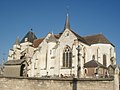
Saint-Georges church
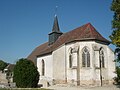
Saint-Pierre church
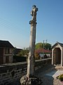
Stone cross in the cemetery (MH)
.jpg)
.jpg)

Web links
Commons : Trouans - collection of images, videos and audio files