
Montiéramey
| Montiéramey | ||
|---|---|---|

|
|
|
| region | Grand Est | |
| Department | Aube | |
| Arrondissement | Troyes | |
| Canton | Vendeuvre-sur-Barse | |
| Community association | Troyes Champagne Métropole | |
| Coordinates | 48 ° 14 ' N , 4 ° 18' E | |
| height | 118-164 m | |
| surface | 6.73 km 2 | |
| Residents | 403 (January 1, 2017) | |
| Population density | 60 inhabitants / km 2 | |
| Post Code | 10270 | |
| INSEE code | 10249 | |

Montiéramey is a French commune with 403 inhabitants (as of January 1, 2017) in the Aube department in the Grand Est region (before 2016 Champagne-Ardenne ); it belongs to the Arrondissement of Troyes and is part of the canton of Vendeuvre-sur-Barse (until 2015 Lusigny-sur-Barse ).
geography
Montiéramey is about 18 kilometers east-southeast of Troyes . Montiéramey is surrounded by the neighboring communities of Lusigny-sur-Barse in the north and west, Mesnil-Saint-Père in the north and east, Briel-sur-Barse in the south-east and Montreuil-sur-Barse in the south and south-west.
Population development
| year | 1962 | 1968 | 1975 | 1982 | 1990 | 1999 | 2006 | 2011 | 2016 |
| Residents | 424 | 451 | 404 | 391 | 51 | 405 | 450 | 434 | 404 |
| Source: Cassini and INSEE | |||||||||
Attractions
- Notre-Dame-de-l'Assomption church from the 12th century, a historic monument since 1840
- Former monastery

Notre-Dame-de-l'Assomption church
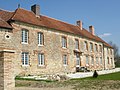
Remains of the former monastery


Web links
Commons : Montiéramey - collection of images, videos and audio files