
La Vendue-Mignot
| La Vendue-Mignot | ||
|---|---|---|
|
||
| region | Grand Est | |
| Department | Aube | |
| Arrondissement | Troyes | |
| Canton | Les Riceys | |
| Community association | Troyes Champagne Métropole | |
| Coordinates | 48 ° 10 ′ N , 4 ° 7 ′ E | |
| height | 121-170 m | |
| surface | 10.48 km 2 | |
| Residents | 250 (January 1, 2017) | |
| Population density | 24 inhabitants / km 2 | |
| Post Code | 10800 | |
| INSEE code | 10402 | |
| Website | http://www.la-vendue-mignot.fr/ | |
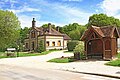
 Town hall (Mairie) of La Vendue-Mignot |
||

La Vendue-Mignot is a French commune with 250 inhabitants (as of January 1, 2017) in the Aube department in the Grand Est region (before 2016 Champagne-Ardenne ). It belongs to the Arrondissement of Troyes and the canton of Les Riceys (until 2015 Bouilly ).
geography
La Vendue-Mignot is about 13 kilometers south-southeast of Troyes . La Vendue-Mignot is surrounded by the neighboring communities of Les Bordes-Aumont in the north, Cormost in the east, Les Loges-Margueron in the south and south-east, Jeugny in the south-west, Maupas in the west and south-west and Villy-le-Bois in the west and north-west.
Population development
| year | 1962 | 1968 | 1975 | 1982 | 1990 | 1999 | 2006 | 2011 | 2016 | ||||||||
| Residents | 135 | 125 | 129 | 183 | 243 | 246 | 232 | 239 | 253 | ||||||||
| Sources: Cassini and INSEE | |||||||||||||||||
Attractions
- Former school, today village community center
- Former brick factory, monument historique since 2000
- Half-timbered houses
old school
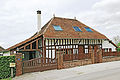
Half-timbered house


Web links
Commons : La Vendue-Mignot - collection of images, videos and audio files