
Polisy
| Polisy | ||
|---|---|---|

|
|
|
| region | Grand Est | |
| Department | Aube | |
| Arrondissement | Troyes | |
| Canton | Bar-sur-Seine | |
| Community association | Barséquanais en Champagne | |
| Coordinates | 48 ° 4 ' N , 4 ° 23' E | |
| height | 157-292 m | |
| surface | 11.35 km 2 | |
| Residents | 193 (January 1, 2017) | |
| Population density | 17 inhabitants / km 2 | |
| Post Code | 10110 | |
| INSEE code | 10296 | |

Polisy is a French commune with 193 inhabitants (as of January 1, 2017) in the Aube department in the Grand Est region ; it belongs to the arrondissement of Troyes and the canton of Bar-sur-Seine .
geography
The community is located around 35 kilometers southeast of Troyes on the banks of the Laignes just before it flows into the Seine . Neighboring municipalities are Polisot in the north, Celles-sur-Ource in the northeast, Buxeuil in the east, Neuville-sur-Seine in the southeast, Balnot-sur-Laignes in the south, Avirey-Lingey in the southwest and Arrelles in the west.
Population development
| year | 1962 | 1968 | 1975 | 1982 | 1990 | 1999 | 2008 | 2017 |
| Residents | 244 | 256 | 215 | 200 | 207 | 211 | 182 | 193 |

Saint-Félix church
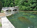
Bridge over the Laignes
,_l%27%C3%A9glise.JPG)
,_pont_sur_la_Laignes.JPG)
.JPG)
Personalities
- Jean de Dinteville (1504–1555 / 57), Seigneur de Polisy, French diplomat (painted by Hans Holbein the Younger )
Web links
Commons : Polisy - collection of images, videos and audio files