
Landreville
| Landreville | ||
|---|---|---|
|
||
| region | Grand Est | |
| Department | Aube | |
| Arrondissement | Troyes | |
| Canton | Bar-sur-Seine | |
| Community association | Barséquanais en Champagne | |
| Coordinates | 48 ° 4 ′ N , 4 ° 28 ′ E | |
| height | 164-321 m | |
| surface | 14.2 km 2 | |
| Residents | 441 (January 1, 2017) | |
| Population density | 31 inhabitants / km 2 | |
| Post Code | 10110 | |
| INSEE code | 10187 | |
| Website | http://www.landreville.fr/ | |
 View of Landreville |
||

Landreville is a French commune with 441 inhabitants (as of January 1, 2017) in the Aube department in the Grand Est region (before 2016 Champagne-Ardenne ); it belongs to the Arrondissement of Troyes and the canton of Bar-sur-Seine (until 2015 Essoyes ). The inhabitants are called Landrevillois .
geography
Landreville is about 45 kilometers southeast of Troyes . Landreville is surrounded by the neighboring communities of Ville-sur-Arce in the north, Viviers-sur-Artaut in the north-east, Loches-sur-Ource in the east, Gyé-sur-Seine in the south, Neuville-sur-Seine in the south-west and Celles-sur- Ource to the west.
Population development
| year | 1962 | 1968 | 1975 | 1982 | 1990 | 1999 | 2006 | 2011 | 2017 |
| Residents | 537 | 541 | 565 | 494 | 534 | 544 | 522 | 542 | 441 |
| Sources: Cassini and INSEE | |||||||||
Attractions
- Notre-Dame-de-l'Assomption church from the 12th century, Monument historique
- Saint-Béline chapel
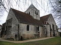
Notre-Dame-de-l'Assomption church

Saint-Béline chapel


Web links
Commons : Landreville - collection of images, videos and audio files