Mesnil-Saint-Père
| Mesnil-Saint-Père | ||
|---|---|---|

|
|
|
| region | Grand Est | |
| Department | Aube | |
| Arrondissement | Troyes | |
| Canton | Vendeuvre-sur-Barse | |
| Community association | Troyes Champagne Métropole | |
| Coordinates | 48 ° 15 ′ N , 4 ° 20 ′ E | |
| height | 132-171 m | |
| surface | 17.45 km 2 | |
| Residents | 496 (January 1, 2017) | |
| Population density | 28 inhabitants / km 2 | |
| Post Code | 10140 | |
| INSEE code | 10238 | |
| Website | http://www.mesnil-saint-pere.com/ | |
 Mesnil-Saint-Père Town Hall |
||
Mesnil-Saint-Père is a French commune with 496 inhabitants (as of January 1, 2017) in the Aube department in the Grand Est region ; it belongs to the Arrondissement of Troyes and is part of the canton of Vendeuvre-sur-Barse (until 2015: canton of Lusigny-sur-Barse ). The inhabitants are called Mesnilois .
geography
Mesnil-Saint-Père is located about 14 kilometers east-southeast of Troyes on an artificial lake, the Lac d'Orient (23 km²). Mesnil-Saint-Père is surrounded by the neighboring communities of Géraudot in the north, Piney in the north and northeast, La Villeneuve-au-Chêne in the east, Briel-sur-Barset in the south, Montiéramey in the southwest and Lusigny-sur-Barse in the west and northwest .
The former route nationale 19 (today's D619) runs through the municipality .
Population development
| year | 1962 | 1968 | 1975 | 1982 | 1990 | 1999 | 2006 | 2012 |
| Residents | 416 | 356 | 364 | 327 | 287 | 331 | 386 | 440 |
| Source: Cassini and INSEE | ||||||||
Attractions
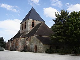
- Church Saint-André from the 12th century, reconstructions from the 16th and 17th century monument historique since 1982

