
Montaulin
| Montaulin | ||
|---|---|---|

|
|
|
| region | Grand Est | |
| Department | Aube | |
| Arrondissement | Troyes | |
| Canton | Vendeuvre-sur-Barse | |
| Community association | Troyes Champagne Métropole | |
| Coordinates | 48 ° 15 ′ N , 4 ° 12 ′ E | |
| height | 107-132 m | |
| surface | 12.45 km 2 | |
| Residents | 807 (January 1, 2017) | |
| Population density | 65 inhabitants / km 2 | |
| Post Code | 10270 | |
| INSEE code | 10245 | |
| Website | http://mairie-montaulin.e-monsite.com/ | |
 Town hall (Mairie) of Montaulin |
||

Montaulin is a French commune with 807 inhabitants (as of January 1, 2017) in the Aube department in the Grand Est region (before 2016 Champagne-Ardenne ); it belongs to the Arrondissement of Troyes and is part of the canton of Vendeuvre-sur-Barse (until 2015: Lusigny-sur-Barse ). The inhabitants are called Montaulinois .
geography
Montaulin is about nine kilometers southeast of Troyes . Montaulin is surrounded by the neighboring communities of Ruvigny in the north, Courteranges in the northeast, Lusigny-sur-Barse in the east, Fresnoy-le-Château in the southeast, Clérey in the south, Verrières in the west and southwest and Rouilly-Saint-Loup in the west and northwest.
The A26 autoroute runs along the western edge of the municipality .
Population development
| year | 1962 | 1968 | 1975 | 1982 | 1990 | 1999 | 2006 | 2011 | 2016 |
| Residents | 353 | 374 | 388 | 538 | 573 | 627 | 701 | 777 | 809 |
| Source: Cassini and INSEE | |||||||||
Attractions
- Saint-Jean-Baptiste church in Daudes, rebuilt in 1771
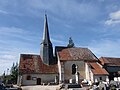
- Saint-Martin church in Montaulin from the 15th century
Saint-Jean-Baptiste church (in Daudes)

Saint-Martin Church (in Montaulin)

.jpg)