Grebin
| coat of arms | Germany map | |
|---|---|---|

|
Coordinates: 54 ° 12 ' N , 10 ° 30' E |
|
| Basic data | ||
| State : | Schleswig-Holstein | |
| Circle : | Plön | |
| Office : | Great Lake Plön | |
| Height : | 29 m above sea level NHN | |
| Area : | 24.14 km 2 | |
| Residents: | 979 (Dec. 31, 2019) | |
| Population density : | 41 inhabitants per km 2 | |
| Postal code : | 24329 | |
| Area code : | 04383 | |
| License plate : | PLÖ | |
| Community key : | 01 0 57 022 | |
| LOCODE : | DE 65U | |
| Office administration address: | Heinrich-Rieper-Strasse 8 24306 Plön |
|
| Website : | ||
| Mayor : | Karl Schuch | |
| Location of the Grebin community in the Plön district | ||
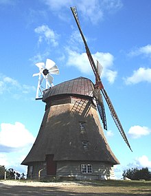
Grebin is a municipality in the Plön district in Schleswig-Holstein . The landmark of the community is the Grebiner mill, classified as a cultural monument and built in 1851 .
Geography and traffic
Grebin is located in the so-called Holstein Switzerland on Lake Grebin . The Schierensee also belongs to the municipality. The district of Görnitz borders on the Schluensee . The Schmarkau flows through the municipality.
Grebin includes the districts of Behl, Breitenstein, Kakelsberg, Görnitz, Treufeld and Schönweide, which was incorporated in 1974. The center of Schönweide was the Schönweider Castle, which was burned down in 2000 and ancestral seat of the von Hollen family .
Grebin is seven kilometers northeast of the district town of Plön and five kilometers northwest of the municipality of Malente . The federal highway 430 runs nearby .
The place is one of the northernmost wine-growing areas in Germany, in 2009 a vineyard with 5300 vines was laid out.


history
In 1433 Grebin was first mentioned in Lübeck's tithe register. From 1910 to 1930 Grebin (Treufeld) was the railway station of the Kleinbahn Kirchbarkau – Preetz – Lütjenburg . On September 1, 1935, Grebin was renamed Greben and received the old name back on July 16, 1946.
Incorporations
On January 1, 1974, the then neighboring community Schönweide was incorporated.
politics
Community representation
Of the eleven seats in the municipal council who CDU and the voter community KWG since the local elections in 2013 three, the SPD two and the Greens and two independent candidates one seat each.
coat of arms
Blazon : “Diagonally quartered with red and silver. 1 and 4 a silver hornbeam leaf, 2 a blue mill wheel, 3 a twelve-part blue stone circle. "
Attractions
safety
The fire protection and general support of the community are of the volunteer fire departments ensures Grebin and Schönweide.
Sports
The TV Grebin is the local sports club.
Personalities
Born in the Schönweide district:
- Georg von Hollen (1845–1900), naval officer, most recently vice admiral
- Karl von Hollen (1839–1895), district administrator and manor owner
- Gustav von Hollen (1851–1917), German cavalry officer, most recently general of the cavalry
Web links
Individual evidence
- ↑ North Statistics Office - Population of the municipalities in Schleswig-Holstein 4th quarter 2019 (XLSX file) (update based on the 2011 census) ( help on this ).
- ↑ Weingut Hof Altmühlen ( Memento of the original from June 10, 2012 in the Internet Archive ) Info: The archive link has been inserted automatically and has not yet been checked. Please check the original and archive link according to the instructions and then remove this notice.
- ^ Federal Statistical Office (ed.): Historical municipality directory for the Federal Republic of Germany. Name, border and key number changes in municipalities, counties and administrative districts from May 27, 1970 to December 31, 1982 . W. Kohlhammer GmbH, Stuttgart / Mainz 1983, ISBN 3-17-003263-1 , p. 183 .
- ↑ Result of the Grebin municipal elections ( memento of the original from June 8, 2013 in the Internet Archive ) Info: The archive link was inserted automatically and has not yet been checked. Please check the original and archive link according to the instructions and then remove this notice. , last accessed July 29, 2013
- ↑ Schleswig-Holstein's municipal coat of arms


