
Rohr (Middle Franconia)
| coat of arms | Germany map | |
|---|---|---|
_COA.svg)
|
Coordinates: 49 ° 21 ' N , 10 ° 53' E |
|
| Basic data | ||
| State : | Bavaria | |
| Administrative region : | Middle Franconia | |
| County : | Roth | |
| Height : | 350 m above sea level NHN | |
| Area : | 46.49 km 2 | |
| Residents: | 3755 (Dec. 31, 2019) | |
| Population density : | 81 inhabitants per km 2 | |
| Postal code : | 91189 | |
| Area code : | 09876 | |
| License plate : | RH, HIP | |
| Community key : | 09 5 76 142 | |
| Community structure: | 16 parts of the community | |
| Address of the municipal administration: |
Alte Gasse 1 91189 pipe |
|
| Website : | ||
| Mayor : | Felix Fröhlich ( SPD ) | |
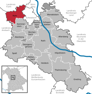
| Location of the municipality of Rohr in the district of Roth | ||
  |
||

Rohr is a municipality in the Central Franconian district of Roth .
geography
location
The Schwabach runs through the municipality in a west-east direction along its entire length. It belongs to the water catchment area of the Rednitz and takes in several small tributaries in the community. In the north, the Zwieselbach flows past the Zwieselhof through Hengdorf and Nemsdorf and with its tributary, the Regelsbach, through the district of Regelsbach. The river valleys and the hills rising to 449 meters characterize the community landscape.
geology
Rohr lies on the southern edge of the Central Franconian Basin. Within this basin landscape, Rohr lies on the Bibert-Schwabach-Rezat-Platte, which rises clearly above the basin in which Nuremberg and Fürth are located.
Neighboring communities
The community borders in the north on Roßtal in the district of Fürth , in the northeast on Stein (also in the district of Fürth) and Nuremberg , in the east on Schwabach , in the south on Kammerstein and in the west on Heilsbronn and Windsbach in the district of Ansbach .
Community structure
The municipality has 16 officially named municipality parts (the type of settlement is indicated in brackets ):
|
|
The lower mill is no longer an officially named part of the municipality.
history
Until the church is planted
Traces of settlement in the area of the municipality go back to the Middle Stone Age . The people of that time were, however, hunters and gatherers without a permanent residence.
Until the 15th century, only a few documents have survived from the area around Rohr, so that historical events from this time are not known. In some cases, however, precise information about the origins of the districts can be found in documents and wills .
In the Middle Ages, Rohr was the main town of the Emmeramer Kloster Mark, a boundary description from the 8th century. The first verifiable historical record of the area around Rohr can be found as the "Mark of St. Emmeram" around the year 800 in a record by Abbot Richolt of the St. Emmeram monastery in Regensburg . The first more precisely datable mention comes from the years 1166 and 1168. Bishop Otto from Eichstätt consecrated a new church in Rohr ("in Rore"). The place name Rohr is derived from the pipe, traced back to the reed vegetation on the banks of the Schwabach. It is likely that a settlement existed on the northern side of the stream before Rohr was founded. The old name of the settlement "Am Sande" is not known. Noble landlords (de Rore) are recorded between 1265 and 1412.
Only during the Margrave Wars (1449 and 1552) are more precise evidence of the municipality around Rohr available again. Many rural properties have been looted and destroyed. In 1632 almost all of the community's citizens fled to Nuremberg because of the looting in connection with the battle of the Alte Veste . There, the plague took away a large part of the refugees. Just seven years later, the biggest catastrophe in the history of the municipality occurred in the village of Rohr. On March 14, 1639, a large part of Rohr burned down when a resident tried to burn the weeds in her garden. Reports indicate that at least eighty houses, the church, taverns, the rectory and the school (sacristan's house) fell victim to the fire. Because of the Thirty Years War, the village was not rebuilt for at least ten years and threatened to deteriorate. Only after the arrival of religious refugees from Austria and Upper Palatinate could the villages and the church be rebuilt.
In the 18th century, community politics was largely shaped by the disputes of the numerous landlords who shared the corridors of the community. Towards the end of the Holy Roman Empire (late 18th century) there were 52 properties in Rohr. The high court south of the Schwabach exercised the Brandenburg-Ansbach Oberamt Schwabach and north of the Schwabach the judge's office in Roßtal . The village and township government had the box office Schwabach held. Were landlords
- The Principality of Ansbach (32 properties; Kastenamt Schwabach: 2 whole courtyards, 1 half courtyard with cone, 2 Köblergüter , 1 estate with inn, 4 Gütlein, 1 empty house ; Rohr church: 1 Halbhof, 1 Köblergut, 1 estate with forge, 2 Gütlein; Spital Schwabach: 1 whole yard, 4 Köbler estates, 1 estate with tavern , 1 estate with inn, 3 empty houses; Heilsbronn monastery administration office : 1 whole yard, 2 half yards, 2 Köbler estates, 1 little estate ),
- the Hochstift Eichstätt ( Kastenamt Abenberg : 1 Gütlein; Kastenamt Spalt : 1 Halbhof; Collegiate Monasteries St. Emmeram and St. Nikolaus zu Spalt: 1 Gütlein),
- the German Order Coming Nuremberg (2 whole yards, 1 Gütlein),
- the imperial city of Nuremberg ( St. Klara monastery office : 1 Gütlein, 1 Gütlein with cone management; State Almosenamt: 1 Ganzhof, 1 two-thirds farm, 1 Köblergut, 2 Gütlein),
- Nuremberg owners ( from the landlord : 1 grinding mill; from Orte : 1 Köblergut, 1 estate with forge; von Scheurl : 1 Ganzhof, 1 Halbhof, 1 Gütlein; von Stromer : 1 Gütlein).
In addition to the property, there was also the parish church, the rectory and communal buildings (shepherd's house, school).
Like the Principality of Ansbach, Rohr was administered by Prussia from 1792 onwards . After several centuries under margravial rule, the municipality of Rohr fell to the Schwabach district administration in 1797, when the Prussian administrators introduced a new administrative order. This also ended the division of the municipality. Since the dissolution of the administrative system in 1806, Rohr has belonged to the Kingdom of Bavaria .
As part of the municipal edict, the Rohr tax district was established in 1808 . The first section included the places Christenmühle and Weiler. The places Dechendorf, Gaulnhofen, Leuzdorf and Prünst belonged to the II. Section. In 1818 the rural community Rohr was formed, which was congruent with the tax district section I. In administration and jurisdiction, it was subordinate to the Schwabach Regional Court and in the financial administration to the Schwabach Rent Office ( renamed Schwabach Tax Office in 1920 ). From 1862, Rohr was administered by the Schwabach district office (renamed the Schwabach district in 1938 ). The jurisdiction remained with the district court Schwabach until 1879 and from 1880 it came to the district court Schwabach . In 1961 the municipality had an area of 11.396 km².
Incorporations
The former Regelsbach districts of Bertelsdorf and Eckershof were incorporated into Stein on January 1, 1967 . On May 1, 1978, the municipalities of Gustenfelden, Prünst and Regelsbach were incorporated into Rohr as part of the municipal reform.
Population development
Little is known about the population in the years before 1500. It can be assumed that the villages were predominantly individual farms or hamlets. After the Thirty Years' War, exiles from Austria settled in the municipality, which enabled the losses from the war to be compensated quickly. It is certain that the main town of Rohr already consisted of more than 30 properties in the 15th century.
Rohr municipality
| year | 1818 | 1840 | 1852 | 1861 | 1867 | 1871 | 1875 | 1880 | 1885 | 1890 | 1895 | 1900 | 1905 | 1910 | 1919 | 1925 | 1933 | 1939 | 1946 | 1950 | 1961 | 1970 | 1987 | 2007 | 2011 | 2016 |
|---|---|---|---|---|---|---|---|---|---|---|---|---|---|---|---|---|---|---|---|---|---|---|---|---|---|---|
| Residents | 467 | 501 | 635 | 662 | 622 | 627 | 622 | 616 | 630 | 594 | 599 | 591 | 582 | 577 | 586 | 621 | 646 | 633 | 888 | 904 | 727 | 796 | 2809 | 3423 | 3542 | 3653 |
| Houses | 71 | 86 | 99 | 101 | 106 | 107 | 124 | 129 | 739 | 1147 | ||||||||||||||||
| source |
District of Rohr with Lower Mill
| year | 1818 | 1840 | 1861 | 1871 | 1885 | 1900 | 1925 | 1950 | 1961 | 1970 | 1987 |
|---|---|---|---|---|---|---|---|---|---|---|---|
| Residents | 407 | 431 | 586 * | 552 | 541 | 527 | 547 | 789 | 660 | 733 | 901 |
| Houses | 60 | 76 | 88 | 94 | 95 | 112 | 117 | 239 | |||
| source |
politics
Municipal council
The Rohr municipal council consists of 16 members:
- CSU 5 seats
- SPD 5 seats
- The free voters 4 seats
- Independent voters 2 seat
(As of: local elections on March 16, 2014)
mayor
badges and flags
The Rohr municipality has had a coat of arms since 1982.
|
|
Blazon : " Square of red and black, covered with two diagonally crossed golden cattails , covered in the middle by a silver bar ."
Red-white-red municipal flag |
| Founding of the coat of arms: A local nobility named de Ror or Rorer has been documented for Rohr since 1285 . The coat of arms of this family shows a shield crossed in red and black, which is covered with a silver bar. This family coat of arms forms the basic figure of the new municipal coat of arms. The cattails were also included in the coat of arms as a "talking" image . The colors silver and black are a reminder of the once strong manorial dependence on the margraves of Brandenburg-Ansbach in the communities of Rohr and Prünst. |
Others
Rohr has been part of the municipal alliance KABS , founded in 2007 , to which the political communities Kammerstein, Abenberg, Büchenbach and Spalt belong.
Culture and sights
theatre
Amateur theater groups of the municipality of Rohr:
- Theater group Rohr e. V. (since 1979)
- Regelsbach theater group
Architectural monuments

- Evangelical Lutheran parish church of St. Emmeram in the Rohr district from 1493
- In 1192, Bishop Otto von Eichstätt consecrated a stone church in Rohr, which replaced an earlier wooden structure. After the village fire of 1639, the church was only rebuilt (makeshift) within a few months in 1650 after the war. The funds needed came from the remaining residents of the community and the surrounding municipalities. The tower and bell house were only rebuilt in 1655. The Rohr church received new bells on January 19, 1667. When they rang for the first time on January 23, Rohr had been without a church for almost 28 years. The shape of the church has remained unchanged.
- While the nave of the church was built in the Baroque style, the choir and tower are Gothic . It can be assumed that the nave fell victim to the fire, but the choir was spared. The church of St. Johannes Baptist in Eibach was used as a template for the tower .
- The interior is dominated by a large gallery on the east and north-east side, which was built in 1697. Around this time the interior was adapted to the style of the time. The pulpit was created in 1696, and the high altar was added in 1715, designed by the court sculptor Fischer in Ansbach and the painter Johann Roßbach.
- The last major renovation took place in 1912 when the level of the nave was raised. The organ dates from 1989 and is based on the Rococo prospectus from 1749.
- The church stands on a headland protruding into the Schwabach Valley and has shaped the townscape of Rohr for centuries.
- Evangelical church and rectory in Regelsbach
- The rectory was built in 1737. It contains rooms with stucco ceilings and the coat of arms of the Nuremberg patrician Ebner family.
- The fortified church of St. George was built in 1295; her nave dates from the 15th century. The rich rococo stucco was added in 1757. Next to the church is the 15th century cemetery fortification with a four meter high wall and a seven meter high gate tower.
- Evangelical Church in Gustenfelden
- The Church of St. Bartholomew was built in 1487. Structural changes date from 1692 and 1869 (new nave). The sacrament house (1487) still exists from the late Gothic furnishings. Like the altar from the 18th century, it was later painted over in 1913. The altarpiece was created by Friedrich Kaulbach in 1869.
- Fortified church in Kottensdorf
- The fortified church in Kottensdorf was built around 1400. The outer facade shows the coat of arms of the Margrave of Brandenburg and the year 1738. On the altar, which was made in 1521, there is a depiction of the birth of Christ by Johannes Heidelberger from Nuremberg. A wooden figure of St. Nicholas and a self-group of three come from the same period.
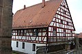
- Numerous half-timbered houses from the 17th and 18th centuries, the Christian mill west of Rohr and the Stubensandsteinhöhle near Wildenbergen are also among the sights of the community.
Sports
- 9-hole golf course in Nemsdorf
- Gymnastics and Sports Club Rohr e. V.
- Tennis Club Regelsbach e. V.
- Modellflugclub Rohr e. V.
- Sportschützengesellschaft Rohr e. V.
- SV Großweismannsdorf-Regelsbach e. V.
Regular events
- Church consecrations
- Culinary artist mile
- Christmas Market
- Drumfire musicians festival Hengdorf
Economy and Infrastructure
economy
The community is predominantly rural. Numerous farmers have their acreage in the municipality. The cultivation of tobacco in particular still plays an important role. A high regional awareness, the apple growing around Gustenfelden. The apples are available in farm shops and at the market in Schwabach. Probably the best-known product from the Rohr community is the Rohrer cookbook Wos gout is und schmeckt , which is published by the Rohr community. The collection of handwritten recipes by women from the region has been sold over 130,000 times to countries around the world since it was first published in 1988.
traffic
- The main town of Rohr is on State Road 2239 , which runs from Müncherlbach to Altdorf near Nuremberg . It is about three kilometers to the federal highway 14 Nürnberg - Ansbach . The A 6 motorway runs south of the municipality . The junctions Neuendettelsau (AS 54) and Schwabach West (AS 55) are each about ten kilometers away. The district road RH 12 / AN 29 runs west over the Christenmühle to Göddeldorf . The district road FÜ 23 / RH 14 runs north to Buchschwabach to the B 14. A community road runs south to Gaulnhofen , another runs northeast to Weiler .
- The distance to Nuremberg Airport is approx. 27 kilometers.
- The rail connection in Schwabach can be reached via the VGN bus service .
- The water trade route of the Main-Danube Canal with the port of Nuremberg is about twelve kilometers away.
education
- Primary school in Regelsbach
- Adult Education Center Rohr
- Evangelical kindergarten in Rohr
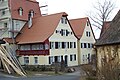
The Christian mill near Rohr
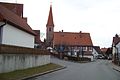
St. Emmeram church tower and rectory
Rectory in Rohr

St. Emmeram

Half-timbered house


literature
- Johann Kaspar Bundschuh : pipe . In: Geographical Statistical-Topographical Lexicon of Franconia . tape 4 : Ni-R . Verlag der Stettinische Buchhandlung, Ulm 1801, DNB 790364301 , OCLC 833753101 , Sp. 579 ( digitized version ).
- Friedrich Eigler : Schwabach (= Historical Atlas of Bavaria, part of Franconia . I, 28). Michael Laßleben, Kallmünz 1990, ISBN 3-7696-9941-6 , p. 419-420, 483-484 .
- Karl Gröber, Felix Mader : City and district of Schwabach (= The art monuments of Bavaria . Middle Franconia 7). R. Oldenburg, Munich 1939, DNB 366496239 , p. 265-267 .
- Georg Muck: History of Heilsbronn Monastery from prehistoric times to modern times . tape 2 . For Kunstreprod. Schmidt, Neustadt an der Aisch 1993, ISBN 3-923006-90-X , p. 279–280 (first edition: Beck, Nördlingen 1879).
- Wolf-Armin von Reitzenstein : Lexicon of Franconian place names. Origin and meaning . Upper Franconia, Middle Franconia, Lower Franconia. CH Beck, Munich 2009, ISBN 978-3-406-59131-0 , p. 192 .
- Martin Schieber: Pipe. From the story of a community in the heart of Middle Franconia. Self-published by the municipality of Rohr i. Mfr., 2006, without ISBN
- Gottfried Stieber: pipe . In: Historical and topographical news from the Principality of Brandenburg-Onolzbach . Johann Jacob Enderes, Schwabach 1761, p. 665-667 ( digitized version ).
- Willi Ulsamer (Ed.): 100 Years of the Schwabach District (1862–1962). A home book . Schwabach 1964, DNB 984880232 , p. 465-468 .
Web links
- Site of pipe
- Rohr (Middle Franconia): Official statistics of the LfStat (PDF; 1.2 MB)
- Rohr in the Topographia Franconiae of the University of Würzburg , accessed on September 23, 2019.
Individual evidence
- ↑ "Data 2" sheet, Statistical Report A1200C 202041 Population of the municipalities, districts and administrative districts 1st quarter 2020 (population based on the 2011 census) ( help ).
- ^ Municipality of Rohr in the local database of the Bavarian State Library Online . Bayerische Staatsbibliothek, accessed on September 23, 2019.
- ↑ W.-A. v. Reitzenstein, p. 192.
- ↑ F. Eigler, p. 419f.
- ↑ F. Eigler, p. 483f.
- ↑ a b c Bavarian State Statistical Office (ed.): Official city directory for Bavaria, territorial status on October 1, 1964 with statistical information from the 1961 census . Issue 260 of the articles on Bavaria's statistics. Munich 1964, DNB 453660959 , Section II, Sp. 826 ( digitized version ).
- ^ Federal Statistical Office (ed.): Historical municipality directory for the Federal Republic of Germany. Name, border and key number changes in municipalities, counties and administrative districts from May 27, 1970 to December 31, 1982 . W. Kohlhammer, Stuttgart / Mainz 1983, ISBN 3-17-003263-1 , p. 732 .
- ↑ a b Only inhabited houses are given. In 1818 these were designated as fireplaces , in 1840 as houses , and from 1871 to 2016 as residential buildings.
- ↑ a b Alphabetical index of all the localities contained in the Rezatkreise according to its constitution by the newest organization: with indication of a. the tax districts, b. Judicial Districts, c. Rent offices in which they are located, then several other statistical notes . Ansbach 1818, p. 77 ( digitized version ). For the municipality of Rohr plus the residents and buildings of Christenmühle (p. 16) and Weiler (p. 101).
- ^ A b Eduard Vetter (Ed.): Statistical handbook and address book of Middle Franconia in the Kingdom of Bavaria . Self-published, Ansbach 1846, p. 239 ( digitized version ). Rohr: 415 inhabitants, 74 houses; Lower mill: 16 E., 2 H.
- ↑ a b c d e f g h i j k l Bavarian State Statistical Office (Hrsg.): Historical municipality directory: The population of the municipalities of Bavaria from 1840 to 1952 (= contributions to Statistics Bavaria . Issue 192). Munich 1954, DNB 451478568 , p. 184 , urn : nbn: de: bvb: 12-bsb00066439-3 ( digitized ).
- ↑ a b Joseph Heyberger, Chr. Schmitt, v. Wachter: Topographical-statistical manual of the Kingdom of Bavaria with an alphabetical local dictionary . In: K. Bayer. Statistical Bureau (Ed.): Bavaria. Regional and folklore of the Kingdom of Bavaria . tape 5 . Literary and artistic establishment of the JG Cotta'schen Buchhandlung, Munich 1867, Sp. 1088 , urn : nbn: de: bvb: 12-bsb10374496-4 ( digitized version ).
- ↑ a b Kgl. Statistical Bureau (ed.): Complete list of localities of the Kingdom of Bavaria. According to districts, administrative districts, court districts and municipalities, including parish, school and post office affiliation ... with an alphabetical general register containing the population according to the results of the census of December 1, 1875 . Adolf Ackermann, Munich 1877, 2nd section (population figures from 1871, cattle figures from 1873), Sp. 1254 , urn : nbn: de: bvb: 12-bsb00052489-4 ( digitized ). Rohr: 544 inhabitants; Lower grinder: 8 E.
- ↑ a b K. Bayer. Statistical Bureau (Ed.): Localities directory of the Kingdom of Bavaria. According to government districts, administrative districts, ... then with an alphabetical register of locations, including the property and the responsible administrative district for each location. LIV. Issue of the contributions to the statistics of the Kingdom of Bavaria. Munich 1888, Section III, Sp. 1189 ( digitized version ). Rohr: 534 inhabitants, 87 residential buildings; Lower mill: 7 E., 1 Wgb.
- ↑ a b K. Bayer. Statistical Bureau (Ed.): Directory of localities of the Kingdom of Bavaria, with alphabetical register of places . LXV. Issue of the contributions to the statistics of the Kingdom of Bavaria. Munich 1904, Section II, Sp. 1261-62 ( digitized version ). Rohr: 519 inhabitants, 93 residential buildings; Lower mill: 8 E., 1 Wgb.
- ↑ a b Bavarian State Statistical Office (ed.): Localities directory for the Free State of Bavaria according to the census of June 16, 1925 and the territorial status of January 1, 1928 . Issue 109 of the articles on Bavaria's statistics. Munich 1928, Section II, Sp. 1299 ( digitized version ).
- ↑ a b Bavarian State Statistical Office (ed.): Official place directory for Bavaria - edited on the basis of the census of September 13, 1950 . Issue 169 of the articles on Bavaria's statistics. Munich 1952, DNB 453660975 , Section II, Sp. 1127 ( digitized version ).
- ↑ a b Bavarian State Statistical Office (Hrsg.): Official local directory for Bavaria . Issue 335 of the articles on Bavaria's statistics. Munich 1973, DNB 740801384 , p. 180 ( digitized version ).
- ↑ a b Bavarian State Office for Statistics and Data Processing (Ed.): Official local directory for Bavaria, territorial status: May 25, 1987 . Issue 450 of the articles on Bavaria's statistics. Munich November 1991, DNB 94240937X , p. 348 ( digitized version ).
- ↑ a b c Rohr (Middle Franconia): Official statistics of the LfStat
- ^ Entry on the coat of arms of Rohr (Middle Franconia) in the database of the House of Bavarian History
- ↑ pipe. In: Kommunalflaggen.eu. Retrieved June 6, 2020 .
- ^ Municipal alliance KABS

Abenberg | Allersberg | Büchenbach | Georgensgmünd | Greding | Heideck | Hilpoltstein | Kammerstein | Rednitzhembach | Pipe | Roth | Röttenbach | Schwanstetten | Gap | Thalmässing | Wendelstein
Unregulated areas
Abenberger Wald |
Dechenwald |
Forest Kleinschwarzenlohe |
Heidenberg |
Soos