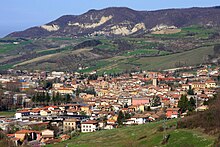
Varzi (Lombardy)
| Varzi | ||
|---|---|---|

|
|
|
| Country | Italy | |
| region | Lombardy | |
| province | Pavia (PV) | |
| Local name | Vors | |
| Coordinates | 44 ° 49 ' N , 9 ° 12' E | |
| height | 416 m slm | |
| surface | 58.61 km² | |
| Residents | 3,094 (Dec. 31, 2019) | |
| Population density | 53 inhabitants / km² | |
| Factions | Bognassi, Bosmenso, Braia di Cella, Caposelva, Casa Bertella, Casa Cabano, Casa Fiori, Castellaro, Cella, Dego, Fontana di Nivione, Monteforte, Nivione, Pietragavina, Rosara, Sagliano Crenna, San Martino, San Michele di Nivione and Santa Cristina | |
| Post Code | 27057 | |
| prefix | 0383 | |
| ISTAT number | 018171 | |
| Popular name | varzesi | |
| Patron saint | San Giorgio | |
| Website | Varzi | |
Varzi is a northern Italian municipality ( comune ) with 3094 inhabitants (as of December 31, 2019) in the province of Pavia in the Region of Lombardy . The patron saint of the place is St. George .
geography
The municipality covers an area of 57.61 km² . The place is at an altitude of 416 meters above sea level on the Staffora . Districts ( frazioni ) are Bognassi, Bosmenso, Braia di Cella, Caposelva, Casa Bertella, Casa Cabano, Casa Fiori, Castellaro, Cella, Dego, Fontana di Nivione, Monteforte, Nivione, Pietragavina, Rosara, Sagliano Crenna, San Martino, San Michele di Nivione and Santa Cristina. The neighboring municipalities are Bagnaria , Fabbrica Curone (AL), Gremiasco (AL), Menconico , Ponte Nice , Romagnese , Santa Margherita di Staffora , Val di Nice , Valverde and Zavattarello . The municipality borders the province of Alessandria .
Varzi had a station on the disused Voghera – Varzi railway .
Attractions
- Capuchin Church ( Chiesa dei Cappuccini ), Romanesque, consecrated in 1594
Personalities
- Pina Carmirelli (1914–1993), violinist
- Carlo Chiappano (1941–1982), racing cyclist
Web links
Individual evidence
- ↑ Statistiche demografiche ISTAT. Monthly population statistics of the Istituto Nazionale di Statistica , as of December 31 of 2019.


