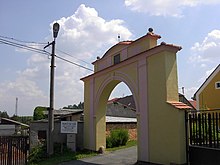
Újezd u Domažlic
| Újezd | ||||
|---|---|---|---|---|
|
||||
| Basic data | ||||
| State : |
|
|||
| Region : | Plzeňský kraj | |||
| District : | Domažlice | |||
| Area : | 1102.1507 ha | |||
| Geographic location : | 49 ° 26 ' N , 12 ° 52' E | |||
| Height: | 503 m nm | |||
| Residents : | 430 (Jan. 1, 2019) | |||
| Postal code : | 344 01 | |||
| License plate : | P | |||
| traffic | ||||
| Street: | Horšovský Týn - Furth in the forest | |||
| Railway connection: | Tachov - Domažlice | |||
| structure | ||||
| Status: | local community | |||
| Districts: | 2 | |||
| administration | ||||
| Mayor : | Václav Kalčík (status: 2014) | |||
| Address: | Újezd 54 344 01 Domažlice |
|||
| Municipality number: | 554383 | |||
| Website : | www.obecujezd.cz | |||
Újezd (popularly Kozinův Újezd , German Aujezd b. Taus ) is a municipality in the Czech Republic . It is located four kilometers west of Domažlice and belongs to the Okres Domažlice .
geography
Újezd is located in the southeast of the Upper Palatinate Forest (Český les) on a saddle surrounded by the hills Václavkova hora (534 m), Hrádek ( Spitzberg , 585 m) and Dubová hůrka (517 m). On the eastern edge of the village, Újezd is touched by state road 26 between Horšovský Týn and Furth im Wald . The railway runs southeast between Domažlice and Tachov , the nearest railway station of which is in Havlovice.
Neighboring towns are Ždánov and Draženov in the north, Petrovice in the northeast, Domažlice in the east, Havlovice in the southeast, Pila in the south, Trhanov in the southwest, Klenčí pod Čerchovem in the west and Postřekov and Pařezov in the northwest.
history
The first documentary mention of Újezd comes from the Chodenprivileg Johann von Luxemburg from the year 1325. The place was one of the free Chodendörfer until the Thirty Years War. In 1621 the residents of Wolf Wilhelm Laminger von Albenreuth's manor in Trhanov were required to use robots . They refused to obey his son Wolf Maximilian Laminger , known as "Lomikar". Jan Sladký Kozina from Újezd became the Chodian spokesman . Until 1848 Újezd remained subject to the Trhanov rule. In 1873 a large fire destroyed parts of the village.
Community structure
The municipality of Újezd consists of the districts and cadastral districts of Petrovice ( Petrowitz ) and Újezd ( Aujezd ). Basic settlement units are Petrovice, Újezd and Újezd-u Pily.
Attractions
- Kozina-Gut, a memorial to Jan Sladký Kozina and Museum of the traditions of Chods
- Church of St. Wenceslas on the village square of Újezd, built in 1891
- Farm estates and chalets in scrap wood construction
- Monument to Jan Sladký Kozina on the Hrádek hill. The 3.20 m high statue on a pedestal was created by the sculptors František Hošek and Čeněk Vosmík and erected in 1895.
Personalities
- Jan Sladký Kozina (1652–1695), leader of the Chod uprising against the "Lomikar"
- Adam Podestát (1653–1710), spokesman for the Chods
Web links
Individual evidence
- ↑ http://www.uir.cz/obec/554383/Ujezd
- ↑ Český statistický úřad - The population of the Czech municipalities as of January 1, 2019 (PDF; 7.4 MiB)
- ↑ http://www.uir.cz/casti-obce-obec/554383/Obec-Ujezd
- ↑ http://www.uir.cz/katastralni-uzemi-obec/554383/Obec-Ujezd
- ↑ http://www.uir.cz/zsj-obec/554383/Obec-Ujezd


