
Hora Svatého Václava
| Hora Svatého Václava | |||||
|---|---|---|---|---|---|
|
|||||
| Basic data | |||||
| State : |
|
||||
| Region : | Plzeňský kraj | ||||
| District : | Domažlice | ||||
| Area : | 765,182 hectares | ||||
| Geographic location : | 49 ° 31 ' N , 12 ° 44' E | ||||
| Height: | 572 m nm | ||||
| Residents : | 65 (Jan. 1, 2019) | ||||
| Postal code : | 345 22 | ||||
| License plate : | P | ||||
| structure | |||||
| Status: | local community | ||||
| Districts: | 3 | ||||
| administration | |||||
| Mayor : | David Kraml (as of 2014) | ||||
| Address: | Hora Svatého Václava 6 345 22 Poběžovice |
||||
| Municipality number: | 566276 | ||||
| Website : | www.horasvatehovaclava.estranky.cz | ||||


.jpg)
Hora Svatého Václava (German mountain ) is a municipality in the Czech Republic . It is located five kilometers northwest of Poběžovice at 572 m on the eastern slope of the Upper Palatinate Forest . The cadastral area is 765 ha.
geography
The village is on the edge of the Český les Nature Park. Neighboring towns are Šidlákov in the west, Drahotín in the east, Načetín in the south and Šibanov in the southwest.
history
The place was first mentioned in a document in 1239 and was probably built around an old fortress. The church of St. Wenceslas has been documented since 1384, when it was already a parish church.
Berg was initially subordinate to Hirschstein Castle, after the Hirschsteiner died out , Teinitz ruled . In 1587 the village consisted of six farms. In 1707 a new parish and school house was built in Berg, which was also called Bergium or Mons St. Wenceslai in old scripts . In 1788 the church, which had meanwhile been assigned to the Stockau monastery , was again given the status of a parish church. In 1839 the village had 173 inhabitants. From the middle of the 19th century, Berg formed a community in the judicial district of Ronsperg or in the district of Bischofteinitz .
The inhabitants of the place lived on agriculture, in which flax cultivation played a major role, and flax spinning. In addition, some residents earned their living in glassworks in the Upper Palatinate Forest. In 1913 there were 165 people in Berg. The rectory burned down in 1927 and was rebuilt in 1932.
At that time, the districts of Schiefernau and Zeisermühl belonged to Berg .
After the Munich Agreement , Berg was added to the German Empire and belonged to the Bischofteinitz district until 1945 . The predominantly German-speaking population was expelled after 1945.
Community structure
The municipality of Hora Svatého Václava consists of the districts and cadastral districts Hora Svatého Václava, Načetín ( Natschetin ) and Šidlákov ( Schilligkau ). The abandoned single-layer Bilý Mlýn ( white mill ) is also in the corridors .

South side of the church
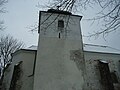
Steeple
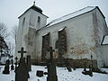
North side of the church
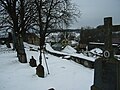
The village seen from the churchyard


Attractions
The St. Wenceslas Church was declared a monument, it is in a bad state of construction.
Web links
Individual evidence
- ↑ http://www.uir.cz/obec/566276/Hora-Svateho-Vaclava
- ↑ Český statistický úřad - The population of the Czech municipalities as of January 1, 2019 (PDF; 7.4 MiB)
- ↑ http://www.uir.cz/casti-obce-obec/566276/Obec-Hora-Svateho-Vaclava
- ↑ http://www.uir.cz/katastralni-uzemi-obec/566276/Obec-Hora-Svateho-Vaclava