
Bitry (Oise)
| Bitry | ||
|---|---|---|
|
||
| region | Hauts-de-France | |
| Department | Oise | |
| Arrondissement | Compiègne | |
| Canton | Compiègne-1 | |
| Community association | Lisieres de l'Oise | |
| Coordinates | 49 ° 25 ' N , 3 ° 5' E | |
| height | 37-144 m | |
| surface | 6.61 km 2 | |
| Residents | 317 (January 1, 2017) | |
| Population density | 48 inhabitants / km 2 | |
| Post Code | 60350 | |
| INSEE code | 60072 | |

Bitry is a northern French municipality with 317 inhabitants (at January 1, 2017) in the department of Oise in the region of Hauts-de-France (before 2016 Picardy ). It belongs to the Arrondissement of Compiègne and the canton of Compiègne-1 ( Attichy until 2015 ).
geography
Bitry is about 23 kilometers east of Compiègne on the Aisne . Bitry is surrounded by the neighboring municipalities of Moulin-sous-Touvent and Saint-Pierre-lès-Bitry in the north, Vic-sur-Aisne in the east, Montigny-Lengrain in the southeast, Courtieux in the south, Jaulzy in the south and southwest and Attichy in the west.
Population development
| year | 1962 | 1968 | 1975 | 1982 | 1990 | 1999 | 2006 | 2013 |
| Residents | 309 | 297 | 287 | 266 | 281 | 303 | 302 | 302 |
| Source: Cassini and INSEE | ||||||||
Attractions
- Church of St-Sulpice-St-Antoine (see also: List of Monuments historiques in Bitry (Oise) )
- Lombardy mansion
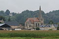
St-Sulpice-St-Antoine church

Lombardy mansion


Web links
Commons : Bitry - collection of images, videos and audio files