
Vic-sur-Aisne
| Vic-sur-Aisne | ||
|---|---|---|
.svg)
|
|
|
| region | Hauts-de-France | |
| Department | Aisne | |
| Arrondissement | Soissons | |
| Canton | Vic-sur-Aisne | |
| Community association | Retz en Valois | |
| Coordinates | 49 ° 24 ' N , 3 ° 6' E | |
| height | 36-143 m | |
| surface | 5.23 km 2 | |
| Residents | 1,645 (January 1, 2017) | |
| Population density | 315 inhabitants / km 2 | |
| Post Code | 02290 | |
| INSEE code | 02795 | |
| Website | http://www.mairie-vicsuraisne.fr/ | |
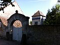
 Vic-sur-Aisne donjon and town hall |
||

Vic-sur-Aisne is a French commune with a population of 1,645 (as at 1st January 2017) in the department of Aisne in the region of Hauts-de-France ; it belongs to the arrondissement of Soissons . The inhabitants are called Vicois .
geography
The municipality is located 15 kilometers west-northwest of Soissons and about 20 kilometers east of Compiègne am Aisne . Vic-sur-Aisne is surrounded by the neighboring communities of Saint-Christophe-à-Berry in the north, Berny-Rivière in the east, Ressons-le-Long in the southeast, Montigny-Lengrain in the south, Bitry in the west and Saint-Pierre-lès- Bitry to the northwest.
Population development
| year | 1962 | 1968 | 1975 | 1982 | 1990 | 1999 | 2006 | 2012 |
| Residents | 1,212 | 1,388 | 1,526 | 1,685 | 1,775 | 1,791 | 1,708 | 1,751 |
| Source: Cassini and INSEE | ||||||||
Attractions
- Domain with donjon, monument historique since 1919
- Roman milestone from the period between 160 and 180 AD
- Sainte-Léocade priory
- Notre-Dame Church, originally from the 11th / 12th centuries. Century, bell tower from the 16th century, monument historique since 1920
- Hostels
- National Military Cemetery
- Wash house

roman milestone
Old Sainte-Léocade priory

Notre-Dame church


Web links
Commons : Vic-sur-Aisne - collection of images, videos and audio files