Corcy
| Corcy | ||
|---|---|---|
|
|
||
| region | Hauts-de-France | |
| Department | Aisne | |
| Arrondissement | Soissons | |
| Canton | Villers-Cotterêts | |
| Community association | Communauté de communes Retz en Valois | |
| Coordinates | 49 ° 15 ' N , 3 ° 13' E | |
| height | 77-155 m | |
| surface | 7.25 km 2 | |
| Residents | 306 (January 1, 2017) | |
| Population density | 42 inhabitants / km 2 | |
| Post Code | 02600 | |
| INSEE code | 02216 | |
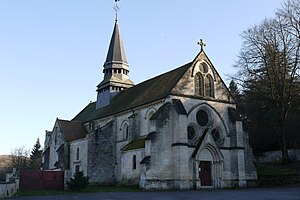
 The Saint-Alban Church |
||
Corcy is a French municipality with 306 inhabitants (as of January 1 2017) in the department of Aisne in the region of Hauts-de-France (former Region: Picardie ). The municipality belongs to the arrondissement of Soissons and is part of the canton of Villers-Cotterêts .
geography
The 9 km east of Villers-Cotterets on the eastern edge of the domain Forst Retz Forest location, from the department of road D80 and the railway line La Plaine Hirson (with a breakpoint) crossed municipality is bordered to the east by the river Savières . The district of Saint-Paul, located on the heights, belongs to Corcy. Neighboring municipalities are Montgobert in the north, Louâtre in the east, Faverolles in the south and Fleury in the west.
Population development
| year | 1962 | 1968 | 1975 | 1982 | 1990 | 1999 | 2007 | 2015 |
| Residents | 206 | 183 | 204 | 187 | 254 | 306 | 309 | 313 |
| Source: Cassini and INSEE | ||||||||
Attractions
- The church of Saint-Alban from the 12th and 13th centuries, largely destroyed in the First World War and rebuilt in 1921, has been classified as a Monument historique since 1920 ( Base Mérimée PA00115615).
Web links
Commons : Corcy - collection of images, videos and audio files


