
Mont-Saint-Martin (Aisne)
| Mont-Saint-Martin | ||
|---|---|---|
|
||
| region | Hauts-de-France | |
| Department | Aisne | |
| Arrondissement | Soissons | |
| Canton | Fère-en-Tardenois | |
| Community association | Communauté de communes du Val de l'Aisne | |
| Coordinates | 49 ° 17 ' N , 3 ° 38' E | |
| height | 73-208 m | |
| surface | 5.81 km 2 | |
| Residents | 74 (January 1, 2017) | |
| Population density | 13 inhabitants / km 2 | |
| Post Code | 02220 | |
| INSEE code | 02523 | |
.JPG) The Mairie |
||

Mont-Saint-Martin is a commune with 74 inhabitants (as at 1st January 2017) in the department of Aisne in the region of Hauts-de-France (former Region: Picardie ). The municipality belongs to the arrondissement of Soissons and is part of the canton of Fère-en-Tardenois .
geography
The municipality in the Tardenois with the district of Resson, located to the west of the D967 département road from Fère-en-Tardenois to Fismes on the border with the Marne department , is bordered in the south by the Ruisseau du Fond de Vau stream and in the east by the Orillon . The distance to Fère-en-Tardenois is around 10 kilometers and to Fismes 4 kilometers. Neighboring municipalities are Saint-Thibaut and Ville-Savoye in the north, Fismes and Saint-Gilles in the east, Mont-sur-Courville in the southeast, Dravegny in the south and Chéry-Chartreuve in the west.
Population development
| year | 1962 | 1968 | 1975 | 1982 | 1990 | 1999 | 2009 | 2015 |
| Residents | 84 | 71 | 56 | 56 | 37 | 40 | 80 | 77 |
| Source: Cassini and INSEE | ||||||||
Attractions
- Castle from the 17th century, partially registered as a monument historique in 1927 ( Base Mérimée PA00115819)
- Parish church of Saint-Martin from the 16th century (equipment Base Palissy IA02002155)
- War memorial (Monument aux morts)

Church and war memorial
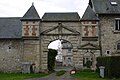
lock
.JPG)
.JPG)