Nampteuil-sous-Muret
| Nampteuil-sous-Muret | ||
|---|---|---|
|
|
||
| region | Hauts-de-France | |
| Department | Aisne | |
| Arrondissement | Soissons | |
| Canton | Villers-Cotterêts | |
| Community association | Communauté de communes du Canton d'Oulchy-le-Château | |
| Coordinates | 49 ° 18 ′ N , 3 ° 26 ′ E | |
| height | 72-171 m | |
| surface | 3.38 km 2 | |
| Residents | 103 (January 1, 2017) | |
| Population density | 30 inhabitants / km 2 | |
| Post Code | 02200 | |
| INSEE code | 02536 | |
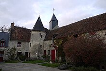
 Place view |
||
Nampteuil-sous-Muret is a French municipality with 103 inhabitants (as of January 1 2017) in the department of Aisne in the region of Hauts-de-France (former Region: Picardie ). The municipality belongs to the arrondissement of Soissons and is part of the canton of Villers-Cotterêts .
geography
In the north of the department of road limited D6 community lies at the confluence of the Ru de Violaine and Ru de Launoy the river Crise that the Aisne flows, 13 km (road distance) southeast of Soissons and 14 km northwest of Fere-en-Tardenois on the D831 department road. Ferme de l'Épitaphe is to the north of the municipality and Le Moulin de Batrand to the south. Neighboring municipalities are Serches in the north, Maast-et-Violaine in the east, Muret-et-Crouttes in the south and Chacrise in the west.
Population development
| year | 1962 | 1968 | 1975 | 1982 | 1990 | 1999 | 2007 | 2017 |
| Residents | 122 | 99 | 83 | 86 | 102 | 56 | 77 | 103 |
| Sources: Cassini and INSEE | ||||||||
Attractions
- Saint-Jacques church from the 12th and 16th centuries, registered as a Monument historique in 1927 ( Base Mérimée PA00115838).


