Ambleny
| Ambleny | ||
|---|---|---|

|
|
|
| region | Hauts-de-France | |
| Department | Aisne | |
| Arrondissement | Soissons | |
| Canton | Vic-sur-Aisne | |
| Community association | Retz en Valois | |
| Coordinates | 49 ° 23 ' N , 3 ° 11' E | |
| height | 38-153 m | |
| surface | 17.32 km 2 | |
| Residents | 1,155 (January 1, 2017) | |
| Population density | 67 inhabitants / km 2 | |
| Post Code | 02290 | |
| INSEE code | 02011 | |
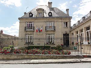
 Ambleny Town Hall (Mairie) |
||
Ambleny is a French commune with 1,155 inhabitants (as of January 1 2017) in the department of Aisne in the region of Hauts-de-France ; it belongs to the arrondissement of Soissons and is part of the canton of Vic-sur-Aisne . The inhabitants are called Amblenois .
geography
Ambleny is eleven kilometers west-southwest of Soissons and about 23 kilometers east of Compiègne . Ambleny is surrounded by the neighboring municipalities of Fontenoy in the north, Pernant in the east, Cutry , Laversine and Saint-Bandry in the south, Montigny-Lengrain in the west and Ressons-le-Long in the west and northwest.
Population development
| year | 1962 | 1968 | 1975 | 1982 | 1990 | 1999 | 2006 | 2013 |
| Residents | 861 | 889 | 844 | 960 | 1,119 | 1,112 | 1,147 | 1,132 |
| Source: Cassini and INSEE | ||||||||
Attractions
- Saint-Martin church from the 12th century, rebuilt in the 16th century, monument historique since 1907
- Donjon from 1140, Monument historique since 1929
- National cemetery in Le Bois-Roger
- Wash house
Personalities
- Pierre Antoine Poiteau (1766-1854), botanist
Web links
Commons : Ambleny - collection of images, videos and audio files


