Vasseny
| Vasseny | ||
|---|---|---|
|
|
||
| region | Hauts-de-France | |
| Department | Aisne | |
| Arrondissement | Soissons | |
| Canton | Fère-en-Tardenois | |
| Community association | Communauté de communes du Val de l'Aisne | |
| Coordinates | 49 ° 21 ′ N , 3 ° 29 ′ E | |
| height | 46–155 m | |
| surface | 3.18 km 2 | |
| Residents | 215 (January 1, 2017) | |
| Population density | 68 inhabitants / km 2 | |
| Post Code | 02220 | |
| INSEE code | 02763 | |
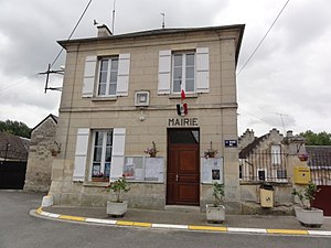
 The Mairie |
||
Vasseny is a commune with 215 inhabitants (as of January 1 2017) in the department of Aisne in the region of Hauts-de-France (former Region: Picardie ). The municipality belongs to the arrondissement of Soissons and is part of the canton of Fère-en-Tardenois .
geography
The municipality with the group of houses La Demi-Lune is off the Soissons with Reims connecting Route nationale 31 ( European route E46 ) and extends to the northeast beyond them to the left bank of the Vesle . The distance from Soissons is around 13 km. Neighboring municipalities are Chassemy and Braine in the northeast and east across the Vesle, Couvrelles in the southeast and south and Ciry-Salsogne in the west.
history
A Gallic settlement of the municipality in the 4th and 5th centuries BC was proven during excavations in 2003. During the First World War there was an alternative hospital in the community, as well as a Bavarian military hospital with a provisional military cemetery. The railway line leading through the municipality has been abandoned.
Population development
| year | 1962 | 1968 | 1975 | 1982 | 1990 | 1999 | 2007 | 2015 |
| Residents | 172 | 182 | 146 | 135 | 131 | 153 | 201 | 207 |
| Source: Cassini and INSEE | ||||||||
Attractions
- The church of Saint-Rupert-et-Saint-Druon from the 12th, 13th and 16th centuries, rebuilt after war damage, classified as Monument historique in 1909 ( Base Mérimée PA00115964).
Individual evidence
- ↑ Une nécropole gauloise mise au jour dans l'Aisne, Le Monde of March 7, 2003

