Chaudun
| Chaudun | ||
|---|---|---|
|
|
||
| region | Hauts-de-France | |
| Department | Aisne | |
| Arrondissement | Soissons | |
| Canton | Villers-Cotterêts | |
| Community association | Communauté de communes du Canton d'Oulchy-le-Château | |
| Coordinates | 49 ° 19 ′ N , 3 ° 16 ′ E | |
| height | 105-157 m | |
| surface | 8.52 km 2 | |
| Residents | 249 (January 1, 2017) | |
| Population density | 29 inhabitants / km 2 | |
| Post Code | 02200 | |
| INSEE code | 02172 | |
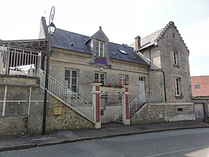
 The Mairie |
||
Chaudun is a commune with 249 inhabitants (as of January 1 2017) in the department of Aisne in the region of Hauts-de-France (former Region: Picardie ). The municipality belongs to the arrondissement of Soissons and is part of the canton of Villers-Cotterêts . The inhabitants are known as Chaudunois (es) .
geography
The municipality is located east of Route nationale 2 , which connects Paris with Soissons , around 9 km southwest of Soissons and 13 km northeast of Villers-Cotterêts . It includes the groups of houses Cravançon on the N2 and Maison Neuve. Neighboring municipalities are Missy-aux-Bois and Ploisy in the north, Berzy-le-Sec in the east, Vierzy in the south, Longpont and Saint-Pierre-Aigle in the southwest and Dommiers in the west.
history
During the First World War , a military airfield was built near Maison Neuve. Heavy fighting took place in Chaudun on May 31, 1918 during the Second Battle of the Marne .
Population development
| year | 1962 | 1968 | 1975 | 1982 | 1990 | 1999 | 2008 | 2015 |
| Residents | 222 | 234 | 294 | 257 | 287 | 282 | 260 | 248 |
| Source: Cassini and INSEE | ||||||||
Attractions
- Notre-Dame church
- Several monuments, u. a. for Charles Mangin and Louis Jaurès
- Claw stand (travail à ferrer)


